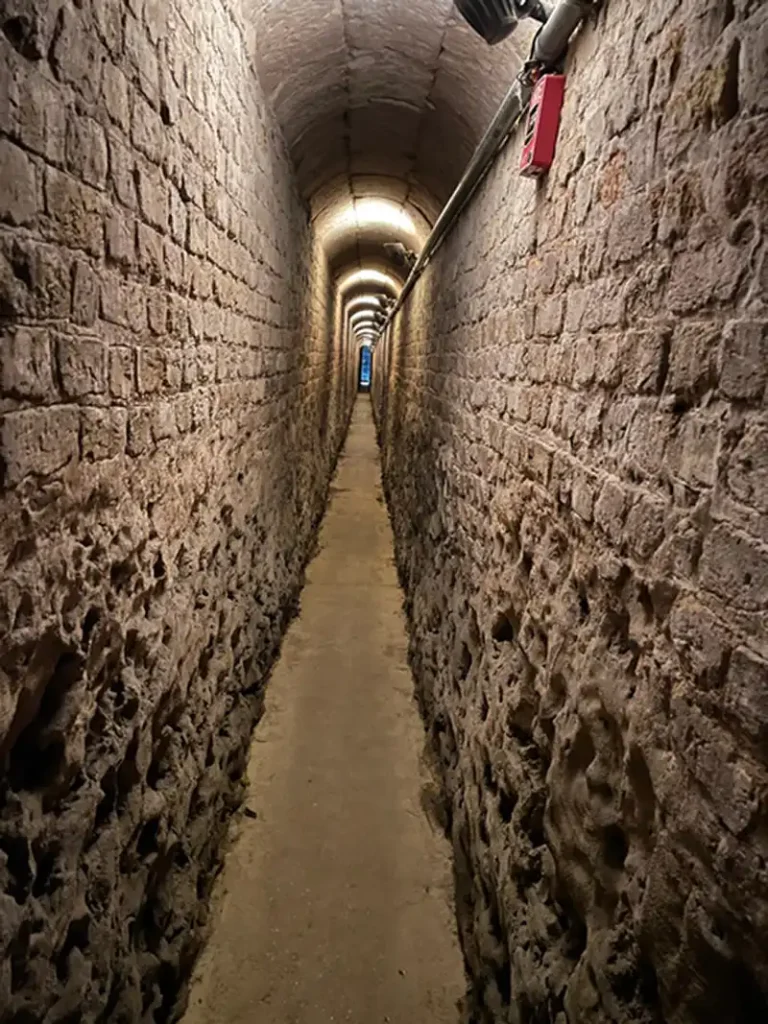
The drainage tunnels at the Barbados Garrison are another interesting piece of the puzzle that makes up the history of Barbados. Rediscovered in 2011, during the renovations at George Washington House, the tunnels were unknown to most Barbadians of that time or had become a faded memory by those who may have been aware of their existence.
Forty plus years prior to their rediscovery, questions about the tunnels, their purpose and history had been discussed in a couple of letters to the Barbados Advocate newspaper.
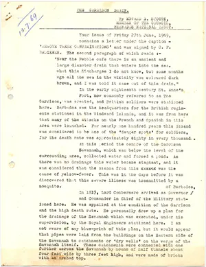
Below is the transcript of a file copy of a letter written by Edward A Stoute – Member of the Council, The Barbados National Trust – published as a letter to the editor, in the Barbados Sunday Advocate Newspaper on Sunday 6th July 1969.
THE GARRISON DRAIN
By EDWARD A. STOUTE, MEMBER OF THE COUNCIL, BARBADOS NATIONAL TRUSTYour issue of Friday 27th June 1969, contains a letter under the caption “REMOVE THESE CONTAMINATIONS” and was signed by C. F. BRUCKNER.
The second paragraph of which reads ; —
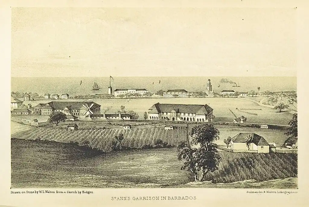
“Near the Pebble café there is an ancient and large diameter drain that enters into the sea, what this discharges I do not know, but some months ago all the sea in the vicinity was coloured dark brown, and I was told it came out of this drain.”In the early eighteenth century St. Anne’s Fort, now commonly referred to as The Garrison, was erected, and British soldiers were stationed here. Barbados was the headquarters for the British regiments stationed in the Windward Islands, and it was from here that many of the attacks on the French and Spanish in this area were launched. For nearly one hundred years this Island was considered to be one of the ‘danger spots’ for soldiers, for the death rate was approximately eighty in every thousand.
At this period the centre of the Garrison Savannah, which was below the level of the surrounding area, collected water and formed a pond. As there was no drainage this water became stagnant, and it was considered that the miasma from this was the cause of yellow—fever. This was in the days before it was discovered that this severe illness was transmitted by a mosquito.
[Editors note: a miasma is an unpleasant or unhealthy smell or vapour. The miasma theory is an abandoned medical theory that held that diseases; such as cholera, chlamydia, yellow fever or plague; were caused by a miasma, a noxious form of “bad air”, also known as “night air”. The theory held that epidemics were caused by miasma, emanating from rotting organic matter.]
In 1817, Lord Combermere arrived as Governor of Barbados, and Commander-in-Chief of the Military stationed here. He was appalled at the condition of the Garrison and the high death rate. He personally drew up a plan for the drainage of the Savannah which was executed, under his supervision, by the Royal Engineers stationed here. I am not aware of any blue—print of this plan, but it would appear that pipes were laid from the buildings on the Eastern side of the Savannah to catchments or ‘dry wells’ on the verge of the Savannah itself. These catchments were connected with one further across the Savannah by means of half tunnels about four feet wide by three feet high, and were made of bricks with an arched top.
From the catchment which is located nearly opposite the Royal Bank Manager’s house, a tunnel about six feet and four feet wide, also built of bricks with an arched top, was laid down Bush Hill and across the road near the Service Station at the bottom of the Garrison Hill, and along the side of the Aquatic Gap.
Until about fifteen years ago the arched top of this tunnel could be seen at the side of thig gap. The manholes in the pavement give access to this tunnel, which terminated in an iron pipe which projects into the sea between the Pebbles café and the Sailing and Cruising Club, and once formed the boundary of The Barbados Aquatic Club.
I am aware of the size of this tunnel, for in the early twenties I was one of a party of boys who lowered ourselves into the well on the Savannah, and using oil lanterns, traversed this tunnel until we came to the end by the sea by what was then The Engineers Pier. We could not get unto the beach for the door at the side of the tunnel was boarded up, so we had to walk back to the spot where we entered and haul ourselves out. It was fortunate that some of our friends had remained on guard at the top of the well so as to lower the ropes to us.
The late Sgt. Major Pescett who was stationed at St. Anne’s Fort towards the close of the last century with his Regiment, told me that on many occasions he was in charge of the detail of soldiers who had the job of cleaning and flushing this tunnel, and confirmed what I have quoted above.
The Last epidemic of yellow-fever here was during the last few months of 1852 and early in 1853. Towards the end of August 1852, there began to appear in the papers death notices which read “‘after a few days illness of fever” , or “after a few hours illness”. The first mention of yellow-fever appears to be the notice announcing the death at St. Anne’s Garrison, of Lt. J. T. Orme, who died on the 10th September. This was not the only case at this Military Station.
On the 14th September 1852, Dr. Sinckler, a Homeopath, advised the Board of Health, that “there would be no question of the advisability of taking immediate steps for improving the sanitary condition of the Market Place. They had conclusive evidence that the very first recent case of fever that occurred in town was in a house near the Market Place. In the yard of that house several hogs were found, and immediately in front of the door was a pool of stagnant water… it was the inhaling of the impure miasma generated by the filth of the hogs and the stagnant water that had aggravated the original symptoms and produced the more malignant type… and it was a fact that there had been much febrile sickness in that direction whilst other parts of the town were partially exempt – as though a dense cloud, surcharged pestilential vapour overhanged the entire neighbourhood”.
Transcript of letter to Editor of the Barbados Advocate Newspaper from Edward Stoute published on Sunday 6th July 1969 . File provided by the Shilstone Library at the Barbados Museum.
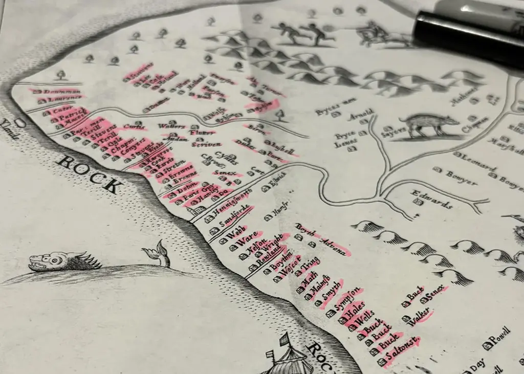
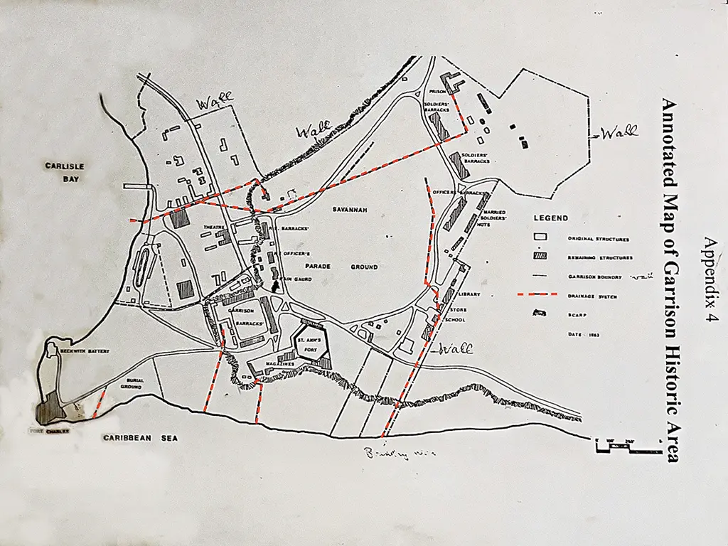
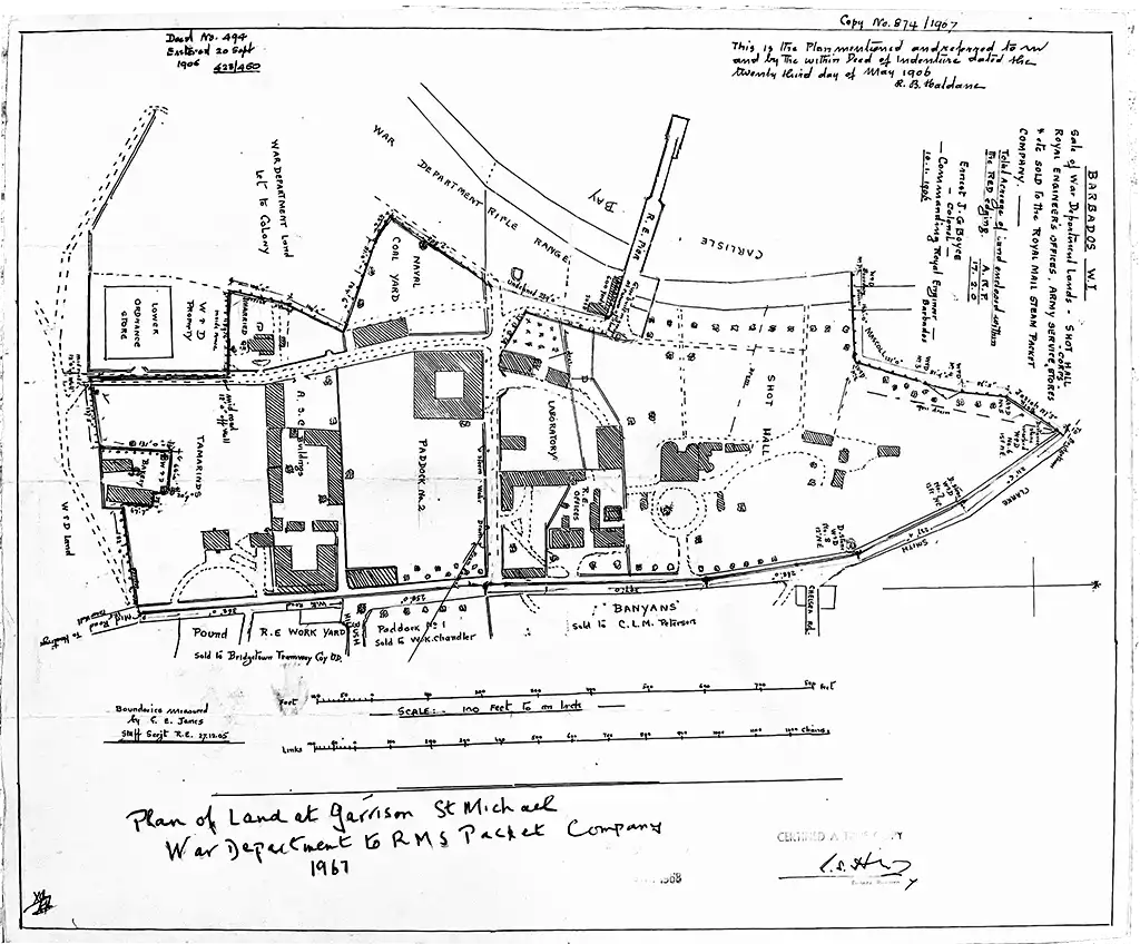
The Barbados Garrison Houses one of the largest collections of old cannons anywhere in the world. Housed near St. Anne’s Fort, the display also has reproductions of many historical maps of the garrison including the one below showing the location of the Garrison Drainage Tunnel system. Originals of many of these maps are stored at the National Archives, Kew, UK.
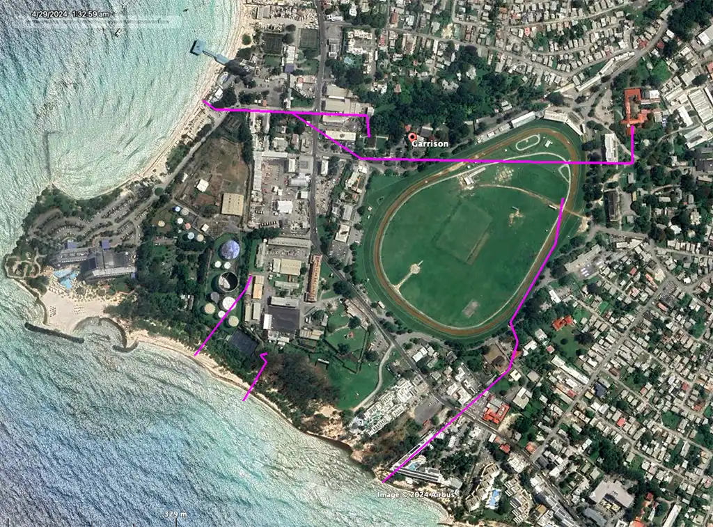
To better understand the location of the Garrison Draining Tunnels, their location has been overlain onto Google Maps.
Here is a sketch of the Barbados Barracks showing the positions of the several Guard Houses in the St. Anne’s Garrison and the vicinity: with the Canteens and Private Shops for the sale of Spirits and Groceries. This sketch accompany Lt. Colonel Moody’s letter No. 462 dated 21st July 1845.
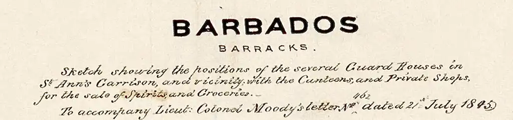
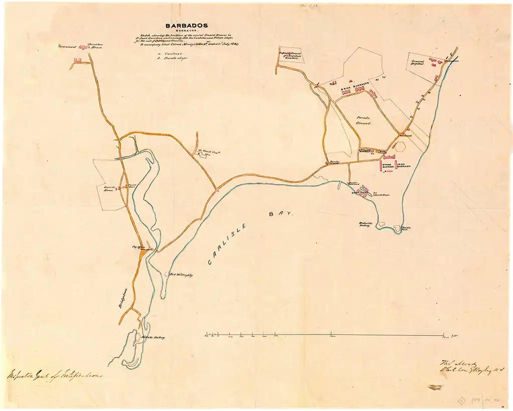
National Archives, Kew, UK, Catalogue reference: MFQ 1/720/11
Click here to see a high resolution image
In 1906 the British War Department sold off the Barbados Garrison land between the main road and the sea to The Royal Mail Steam Packet Company and others. Today this would be the site of the Barbados Yacht Club, the Island Inn, the Radisson Hotel, a shopping mall, gas station, Christian Science Library and Barbados Light and Power, to name a few. The main drainage tunnel would have entered the sea near present day Pebbles Beach.
For additional historical maps of Barbados see:
- The Printed Maps of Barbados – Part 3: 1800 – 1900
- The Printed Maps of Barbados – Part 4: 1900 – 1980s.
In conclusion, the drainage system, often referred to as the Garrison Tunnels, remain an important historical and architectural feature, contributing to the overall preservation of the Garrison area, which is now part of a UNESCO World Heritage Site.
Some background on Edward A Stoute:
Edward Stoute, like Warren Alleyne a dedicated Council member of the National Trust, was another passionate layman with a penchant for collecting historical facts and stories of Barbados, which were published in the Sunday Advocate for some years. He was a chatty raconteur. The National Trust published a collection of his articles in a book “Glimpses of Old Barbados”.
All three of these gentlemen could perhaps be called story tellers rather than formal historians, and the humour and anecdotes in Louis Lynch’s book were memorable. [the third taken from the same article was: “John Poyer, whose The History of Barbados (1808) was an ambitious but somewhat political and not altogether accurate history by a well-informed Barbadian”.]
These writers did not have the formal training or environment of our much published university historians, Sir Woodville Marshall, Dr. Karl Watson, Sir Hilary Beckles, Professor Pedro Welch and others, but their contribution to the public awareness has been invaluable.
Profile of Edward Stoute by Sir Henry Fraser in the Barbados Advocate – 9th October 2017: Things That Matter.
Some background on Lord Combermere:
Lord Combermere is often credited with overseeing the construction of the drainage tunnels, yet locating original plans or correspondence related to their construction, as noted by Edward Stoute, has proven to be elusive. Perhaps with further research and as more historical documents become digitized, collaborative evidence will be found.
Special thanks:
Our thanks to Harriet Pierce of the Barbados Museum for sourcing the file copy of Edward Stoute’s letter to the Sunday Advocate: THE GARRISON DRAIN.