
Kilimanjaro is the highest free-standing mountain in the world, at 5,895 Meters the 4th highest of the 7 summits, the easiest of the 7 summits to climb and the one best known to armchair adventurers.
“Free-standing” means it stands alone and is not part of a mountain range. Kilimanjaro also beats Mount Everest (8,849m) in height from base to summit. Mount Everest from base to summit is 3,840m whereas Mount Kilimanjaro rises 4,000m from the surrounding savannah to its peak.
The Seven Summits refers to the highest peak on each of the seven continents of the world:
- Asia — Mount Everest 8,849m (Tibet & India)
- South America — Aconcagua 6,962m (Argentina, near the border with Chile)
- North America — Denali (Mount McKinley) 6,193m (Alaska)
- Africa — Mount Kilimanjaro 5,895m (Tanzania, near the border with Kenya)
- Europe — Mount Elbrus, 5642m (SW Russia)
- Antarctica — Vinson Massif 5,895m
- Oceania — Puncak Jaya (Carstensz Pyramid) 4,884m (New Guinea)
To Lucy Kilimanjaro was the home to evil spirits that made you feel dizzy and ill if you ventured too far up its slopes. If you survived the climb there was water hard as rock and fire and smoke coming from the ground.
To the Chaga, who have lived on the slopes of Kilimanjaro for the past 300 to 400 years, it was the source of water and fertile soil that makes their crops flourish.
To the European explorers of the 1800’s Kilimanjaro was a place to explore and be the first to “discover” it.
The first European to get close to Kilimanjaro in modern times was the German missionary Johannes Rebmann in 1848. From the foothills he saw snow on the summit. When he returned to Europe and published his findings no one believed that snow could exist so close to the equator. The Celebrated Armchair Geographer William Cooley wrote in the Athenaeum in May 1849 “I deny altogether the existence of snow on Mount Kilimanjaro”.
For the modern tourist it is an easy mountain to climb. You can fly from London, climb the mountain and be back home in 7 days.
In 2002 Dr. Haresh Gopwani, a regular hiker with the Barbados National Trust, was organising a group to climb Mount Kilimanjaro. By the end of the year we had started training for the adventure which was scheduled for July 2003.
We continued our training into 2003 gradually increasing the weight in the packs. By the time we left I was able to carry +15Kg for more than 4 hours and climb 800 meters in 30° C. This training certainly paid off on the last day when I needed to draw on every bit of reserve I had.
We left Barbados on 7th July for London. I spent the next day with family and did shopping for gaiters (which I still use) and other gear.
The group met at the departure gate at Heathrow for our flight to Nairobi which went smoothly. We cleared customs and met the advance party who arrived the day before. It felt good to be back together with friends that we had trained with for the past 8 months.
Our gear was loaded on a bus, most of which had to go on the roof and we drove to Mosi in Tanzania. We stayed at the New Castle Hotel, which I would be generous and give it a half of a star.
When we checked in I was given a pair of slippers to wear in the shower. When I saw the shower I decided to wear my hiking boots instead!
However some of us left a duffel bag until we returned from the Kilimanjaro and not one item was missing. This is more that I can say for some of the better hotels I have stayed at.
After dinner we retired early and had a good night sleep. We expected that we would leave early but by the time the bus arrived and we loaded it we did not leave to 11am. We were on Africa time.
At this point we split into 2 parties and used different routes to get to the summit. The plan was that we would meet at the top.

It was 20Km from the hotel to Umbwe where we started the trek. After we checked in with the rangers and met our guides and porters we left at 1.30pm.
DAY 1 Mosi (2,000M) to Forest Camp (3,000M).
The first day we hiked through dense rain forest. Massive trees, ferns and vines surrounded the path. The trail was very wet and muddy with many roots and rocks that made walking difficult. Part followed a saddle back with deep valleys on both sides. I saw a few birds but for the most part there was no sign of wildlife.
We reached camp by 6.30pm. The campsite was on a muddy, wet and slippery slope under trees with almost constant rain. After a good dinner it was into the tents to get some sleep.
Today was a learning process for us in camp craft. If our preparation lacked in any way it was that we did not camp and get accustomed to sleeping in tents.
Day2 Forest Camp to Baranco (3,900M)
We were up early, as I do not think any of us slept well. Our first breakfast was good and nutritious, as were all of the meals that the cook prepared for the entire trip.
The first part of the walk was the same as yesterday, constant climb through wet rain forest. Suddenly we walked out of the forest. I am always amazed at how quickly forest gives way to grass land when hiking up a mountain. It was the same in Ushuaia when I hiked there.
The vegetation changed, Instead of tall trees, plants more suited to a drier climate were predominant.
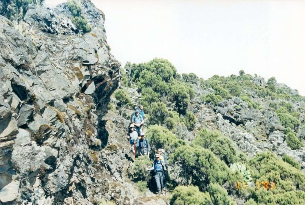
We had lunch on a rock outcrop and relaxed for a while. There was never any pressure from the guides to hurry up. The advice they gave was “pole pole” which means slowly. When hiking above 3000 meters there is no better advice that you can give.
For anyone attempting any high level hikes you should be first to leave camp and the last to arrive in the evening. When you reach camp, relax for a while and if possible take a short walk to ascend another 200 meters and sit and watch the sun set. When you sleep at the lower level you will feel better. This helps you to acclimatize. Drink as much water as you can.
We arrived at Barranco about 3pm where we camped for two nights. The Barranco camp is in a shallow valley with lots of room for tents. After resting for a while we climbed part of the Barranco Wall and had good views of the surrounding area.
We could see the route we were planning to take and it looked a formidable task.
I was beginning to feel some effects of the altitude, mainly shortness of breath. We had another good dinner with plenty of food and drink and retired early to the tent.
Barranco to Lava Towers (4,300Meters) and back
After breakfast we walked to Lava Towers, a rock formation about 75 meters high. We had a slow walk for 3 hours, rested in the shade and ate our lunch. It is the junction of many paths and there were 2 other groups in the area.
In the distance we could see Arrow Glacier and the Western Breach appeared closer, but still looked a formidable climb. The walk back to Barranco took a slightly different route and we arrived there while the sun was still high.
As I walked into camp one of the cooks gave me a plate of spaghetti and mackerel, something I do not normally relish. However this is the best tasting meal I have ever had. Nothing before or after has come close. Dinner was later and I ate another good helping.
Later in the evening the other group arrived having crossed the Shira Plateau. They camped near to us and we visited each other during the evening and exchanged stories. So far all was going according to plan.
Barranco to Arrow Glacier (4,700M)
We left Barranco about 9.30 and arrived at camp around 1.30pm. As with the previous days I walked slowly to let my body adjust and tried to keep my heart rate as low as possible.
The views on the mountain, the snow and ice were brilliant and made walking slowly all the easier. We walked through a dry desert, very little rain falls here and consequently there is little vegetation.
The campsite was at the head of a valley and surrounded by almost vertical cliffs. We were above the clouds and saw the top of Mount Meru sticking through the clouds. For the first time I had the feeling of how high we were.
I felt the effects of the altitude: shortness of breath, tiredness, and no taste. All of us felt the same way. Thankfully we operated as a team and made sure that everyone ate something. We turned in early but I do not think any of us slept. I did go outside during the night and the view was magnificent. It was full moon and the reflection on the ice and on the tops of the clouds is something I will never forget. Too bad it was so cold I could not stay out and enjoy it. The water in my water bottle froze while in my tent.
Arrow Glacier to Uhuru Peak (5,895M)
At 1am we had a hot drink, a snack and started the long slow climb up what seemed an almost vertical rock face. However the guides knew what they were doing and we slowly inched our way up. At times we had to walk over snow and patches of ice. We did not have crampons so had to careful. There was one place where we had to climb up onto a ledge.
Looking back to the camp in the moonlight and later with the sun rising over the plains of the Serengeti is a sight I will never forget. To bad no one had the energy to take a picture. We were all concentrating on the job at hand and that was to get to the to the top in one piece.
We got to the crater of the volcano at 8am. Everyone rested and tried to catch their breath. It was cold. But we still had more climbing to come.
To get the highest peak we had to cross a snowfield and climb a scree slope about 150 meters high. Nothing at sea level, but at almost 6,000 meters it seemed impossible. I do not know how I made it. I continued, as I knew it would be impossible to return the way we came up. By now the sun would be melting the snow and ice and be very dangerous to walk on.
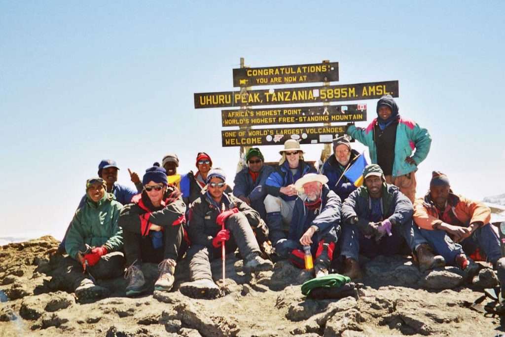
Around midday, we finally arrived at the highest point of Africa. The irony is that from the summit there is no view of the surrounding country as it is a flat topped mountain. The views are on the way up and down. We took the traditional pictures of the group and rested for a while.
Then it was time to descend via Stella Point and to the Mweke Route. Whichever route you take up everyone descends by the same route. This is to avoid a bottleneck in any of the paths. I was reluctant to leave so quickly and Haresh and I were the last off the mountain.
The initial decent was a steep scree slope that seemed to go on forever. But with each step breathing became easier and I felt strong. We reached Barafu camp (4,600M) around 4.30pm and stopped a while. We had a cup of tea and biscuit compliments of another group, which was very welcome.
We saw our camp at Mweka (3,100M) from a long way away but no matter how far we walked it seemed to keep receding. Must have been some African witchcraft. But we made it around sunset and were the last in.
I started today at 1am and got into camp around 5.30pm. A long day. I remember having a beer and dinner and not much else.
Next morning we slowly packed and walked for a few hours to the Mweka gate through the rain forest. It was similar to the first day but going down was a lot easier. Our lungs were accustomed too much higher altitudes we all felt fit.
I quote from my log: “The past 5 days have been the hardest of my life but it was worth every dollar, bit of pain and energy expended over the past 8 months”.
My feelings then and today, 12 years later, are the same.
You can click on the thumbnail image to see a larger image with captions.