
The old US Navy Facility – Barbados at Harrison’s Point, St. Lucy on the North West coast of Barbados is back in the news. In the 1950 and 1960s this US Naval Facility in Barbados was a very important shore based soviet submarine listening station. It had many names: US Navy Facility – Barbados, NAVFAC Barbados and Barbados Oceanographic Research Facility, the latter being the cover story.

In April 2020 the derelict US Naval Facility at Harrison’s Point was re-purposed by the Government of Barbados as its Covid-19 isolation centre. Since being vacated by the US Navy in 1979 the site has had many uses: it has been used by the Barbados Defence Force, the Barbados Youth Service as a youth rehabilitation centre and then in 2005 as temporary prison after HMP Glendairy was burnt down.
In the mid-1950’s, during the Cold War, NAVFAC Barbados was a top secret US Navy underwater surveillance facility used to track Soviet submarines as part of a chain of listening posts that ran from Nova Scotia to Barbados. Additional sites were then added on the Pacific coast and other places around the world. The SOund SUrveillance System (SOSUS) was a multibillion-dollar network of hydrophone arrays mounted deep on the seafloor throughout the Atlantic and Pacific oceans – passively listening for Soviet submarines.

source: wikiwand.com
The SOSUS system takes advantage of the sound channel that exists in the ocean, which allows low-frequency sound to travel great distances. This sound channel is called the SOund Fixing And Ranging (SOFAR) channel. Low-frequency sound generated by submarines can be detected at long ranges by hydrophone arrays located on continental slopes and connected by undersea cables to onshore facilities. These hydrophone arrays listened to the ocean, recorded the sounds and transmitted the data back to shore stations for analysis. The beauty of SOSUS was it was passive listening – which made it very hard to detect.

NAVFAC Barbados was commissioned on 1st October 1957 and decommissioned 22 years later on 31st March 1979. During its operational life it had a complement of about 12 officers and 88 enlisted personnel. Given what was being undertaken at NAVFAC Barbados the base was pretty much a self contained unit and had a low key profile.
The top secret cold war classification of NAVFAC Barbados has meant it has been very difficult to find anyone who was based there from 1957 to 1979 who would agree to talk about the work undertaken – even though a lot of the operational details were long ago obtained and acted upon by the Soviet Union.
The response from those associated with the project that we have approached has been consistent: they could not confirm nor deny any information regarding NAVFAC Barbados for fear of committing US National Security classified information violations.
This post has been “pieced” together using publicly available material.
NAVFAC Barbados
NAVFAC Barbados opened about one-month after the US Navy Facility established on the island of Eleuthera in The Bahamas and was one of the many secret underwater listening stations that were part of the SOSUS used by the Americans to track Soviet submarines.

NAVFAC Barbados on 6th July 1962 had the distinction of making the first system detection of a Soviet nuclear submarine coming into the Atlantic through the Greenland-Iceland-United Kingdom (GIUK) gap by an array. This detection gives an indication of the range at which Soviet submarines could be detected using SOSUS technology exploiting the SOFAR channel. It puts into perspective the strategic value of the SOSUS technology to the national security of the USA during the late 1950s to late 1970s and why it was such a closely guarded secret, why the NAVFAC Barbados base was self-contained and why forty plus years after closure that those who worked at the facility are still tight lipped.
The 1950’s and 1960’s witnessed the birth, development and growth of undersea surveillance in the form of SOSUS. With the 70’s came technology upgrades both in, shore based and underwater systems resulting in the disbandment of many facilities such as Barbados in 1979. The disbandment of Barbados in 1979 coincided with the Barbados Government under Prime Minister Tom Adams refusing to extend the NAVFAC lease unless the rent was substantially increased.
To put the NAVFAC Barbados lease negotiations of the mid 1970s in perspective: there was some US:Barbados tension. Operation Carlotta happened in late November 1975 while Errol Barrow was still Prime Minister. The retaliatory bombing by US agents of Cubana flight 455 en route from Barbados to Jamaica happened in September 1976 soon after Prime Minister Tom Adams took office.
It is very likely the Barbados negotiation team would have been unaware about the technological advances, putting them at a negotiation disadvantage. By the late 1970s the technology had moved on. NAVFAC Barbados was no longer critical to the National Security of the USA. That was the US stance – rather than increase the annual rent the US Navy opted to walk away and close NAVFAC Barbados in March 1979.
Pat Callender was part of the negotiation team for the renewal of the agreement for the U.S Naval Facility at Harrison’s Point, St. Lucy. The Barbados negotiation team was led by Algernon Symmonds who was a qualified lawyer, past High Commissioner to Britain, Head of the Civil Service and Permanent Secretary in the Ministry of Foreign Affairs. He says:
These negotiations took place in July 1978 . The Americans displayed an arrogant attitude which left us in no doubt they were not serious about negotiating the lease renewal for NAVFAC Barbados given that satellite technology and more sophisticated anti-submarine aircraft had been developed. NAVFAC Barbados was now of lesser importance to the National Security of the USA and the Americans decided to abandon the base on 31st March 1979.
Further detail can be found in Pat Callender’s book: Flight Paths & Missing Connections @ Barbados.
It is quite possible there were other things the Barbados Government negotiation team might not have known about. For instance was there a second listening facility on Barbados? In some of the documentation Barbados was mentioned as early as 1952. The location of Barbados made it an ideal spot for a listening station, however, construction of NAVFAC Barbados did not commence until November 1956? Was that back-up facility operational post NAVFAC Barbados closure on 31st March 1979? The answer is – quite possibly.

Destroyers for bases deal
To understand how this cold war US Naval Facility came to be located in Barbados we need to go back in time.
The presence of US defence installations within British Colonies was provided for initially by the “destroyers for bases” deal of 1941 between US President Roosevelt and British War-time Prime Mister Winston Churchill, under which the UK granted the US 99-year leases on a series of base sites in the Western Hemisphere. This was supplemented in Barbados by the 1956 Oceanographic Research Station Agreement.
Within the West Indies and borders of Central and South America the US had a number of facilities that included:
- Antigua
Naval facility, Guided missile tracking station - Bahama Islands
Grand Bahama – Guided missile tracking station
Eleuthera – Naval experimental facility, Naval facility, Guided missile tracking station
Mayaguana – Guided missile tracking station - Barbados – Naval facility
- Brazil
Island of Fernando de Noronha – Guided missile tracking station - Cuba
Guantanamo Bay – Naval air station, Naval base - Dominican Republic
Sabana de la Mar- Guided missile tracking station - El Salvador
San Salvador – Naval facility, LORAN station, Guided missile tracking station - Panama
Canal Zone – Caribbean Command (Army, Navy, Air)—Quarry Heights, Headquarters, US Army, Caribbean—Fort Amador, Headquarters, 15th Naval District—Fort Amador, Naval degaussing station—Fort Amador, Naval stations—Coco Solo and Rodman, Naval radio stations—Farfan, Galeta Island, and Summit, Naval communications station—Balboa, Albrook, France, and Howard Air Force Bases, Headquarters, Caribbean Air Command—Albrook Air Force Base
Taboga Island – Air navigation and communications site
Rio Hato – Army training area - Puerto Rico
Ceiba – Roosevelt Roads (Rodas Roosevelt) Naval station
San Juan- Headquarters, US Army Forces, Antilles, Headquarters, Commander, Caribbean Sea Frontier, Headquarters, 10th Naval District, Naval communications station, Naval station, Naval radio station
Sabana Seca – Naval radio station
Aguadilla – Ramey Air Force Base (near Aguadilla)
Mayagüez – Guided missile tracking station - St. Kitts
St. Christopher – LORAN station - St. Lucia – Guided missile tracking station
- Tobago – LORAN station
- Trinidad
Chaguaramas – Naval station, Naval air station, Experimental early warning radar facility - Turks and Caicos Islands
South Caicos – LORAN station
Grand Turk- Naval facility, LORAN station, Guided missile tracking station
Sound Surveillance System (SOSUS)

The SOSUS system was a highly complex passive acoustic surveillance system that evolved with advances in technology. In the 1950s, 1960s and 1970s it played a major intelligence gathering role during the cold war providing accurate knowledge of the location of Soviet submarines.
The end of World War II saw the beginning of the cold war between the Soviet Union and the United States and its allies. By early 1950, the US Navy realised that Soviet submarines, which were based on the best of German World War II technology, posed a grave threat to America’s security.
Frederick Hunt, who was the head of Harvard University’s Underwater Sound Laboratory during WWII, argued that the US Navy could use the SOFAR channel to detect submarines at distances of hundreds of miles by listening for the sound signatures that they generated.
The SOFAR phenomenon is an important factor in ocean surveillance. The deep sound channel was discovered and described independently by Maurice Ewing and J. Lamar Worzel at Columbia University situated in New York City and Leonid Brekhovskikh at the Lebedev Physics Institute of the Russian Academy of Sciences, situated in Moscow in the 1940s. In testing the concept in 1944 Ewing and Worzel hung a hydrophone from a sailing vessel assigned to the Underwater Sound Laboratory with a second ship setting off explosive charges up to 900 miles away.
In the early 1950‘s the US Navy launched Project Jezebel that would later become known as the SOund SUrveillance System (SOSUS). Arrays of hydrophones were placed on the ocean bottom and connected by underwater cables to processing centres located on shore. The system was passive. It did not ping, it only listened.
Under a cloak of great secrecy, late in 1950, the Office of Naval Research (ONR) funded the American Telephone and Telegraph Company (AT&T) and its manufacturing arm, Western Electric, to develop an undersea surveillance system designed to detect and track Soviet submarines using the SOFAR channel. The initial effort was code-named Project Jezebel. The system that resulted was given the then highly classified name Sound Surveillance System (SOSUS). Eventually it was given an unclassified designation, Project Caesar.
In an extraordinary engineering effort, arrays of hydrophones were placed on the ocean bottom. The hydrophones were connected by underwater cables to processing centres located on shore called “Naval Facilities (NAVFACs).” The first prototype of a full-size SOSUS installation — a 1,000-foot-long horizontal line array of 40 hydrophones laid on the seafloor at a depth of 1440 feet — was deployed off the island of Eleuthera in the Bahamas during January 1952. After tests in which the array proved able to detect a US submarine, the Navy decided to install similar arrays along the entire US East Coast.
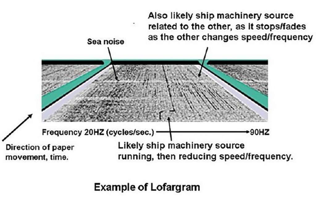
In order to analyse the signals, AT&T adapted a device called a sound spectrogram, which had recently been invented to analyse speech sounds. The Low Frequency Analysis and Recording (LOFAR) instruments installed at the NAVFACs were designed to analyse low-frequency underwater sounds to show which frequencies were present. The distinctive sound signatures generated by submarines could then be seen in what were called LOFARgrams.


The SOSUS system was very successful in detecting and tracking the noisy diesel and then nuclear Soviet submarines of the cold war. The sailors operating the early SOSUS arrays also detected some sounds whose sources were at first unknown. One particular unknown sound was attributed to the “Jezebel Monster.” The sound was later found to be low-frequency blue and fin whale vocalizations.
The early SOSUS line arrays were located at the edge of the continental shelf looking out into the deep ocean. At the time, cable lengths were limited to less than 150 miles (241 kilometres), and the NAVFACs therefore had to be located at coastal sites where the shelf break came closest to land. In the 1980s, improved cable technology, closely related to the technology used in trans-oceanic telephone cables, also allowed the arrays to be located farther from the NAVFACs. All of the coastal Atlantic and Caribbean sites were replaced by Naval Ocean Processing Facility (NOPF) Dam Neck.
NAVFAC Barbados was the southernmost of the original Atlantic Sound Surveillance System (SOSUS) shore terminals. Here the output of the hydrophone array at sea was processed and displayed by means of the Low Frequency Analyzer and Recorder (LOFAR) grams in what was known as the NAVFAC Terminal Building.
Naval personnel became adept at interpreting the sounds they picked up, they could distinguish between whales, other ships and various Russian submarines.
The system is said to have been so sensitive that it could even detect Russian bombers flying thousands of feet in the air, as the tips of their propellers reached supersonic speeds and produced small sonic booms.
The SOSUS Cover Story
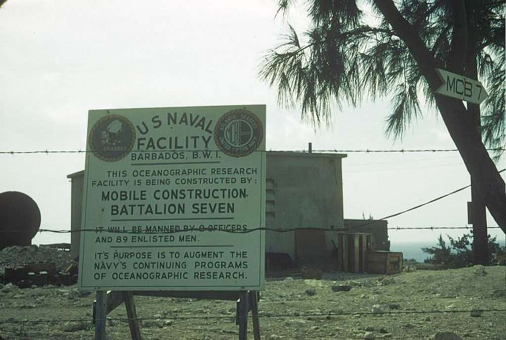
Sometime shortly after the establishment of Project Caesar in 1952 and the installation of Naval Facilities in 1954, the following unclassified cover story was developed and used to describe the mission of the NAVFACs and those who supported them. The slogan “We Serve In Silence” was widely adopted and displayed at many of the Naval Facilities. The cover story was used until 1991.
“During World War II, the U. S. Navy’s efforts against the submarine threat were frequently frustrated because of limitations in its knowledge of the ocean environment and lack of information concerning oceanographic and acoustic conditions off the continental coasts. It became apparent at the end of the war that the German Navy had better information than the U. S. on ocean areas of the Atlantic and Pacific. Consequently, since the war, the U. S. Navy has maintained a continuing program of oceanographic surveys designed to provide more detailed information on currents, temperature, salinity and other factors which comprise the oceanic environment and affect the transmission of sound in sea water The U. S. Navy is determined to never again lag behind others in its knowledge of this vital area.”
“This program of oceanographic and acoustic surveys requires ships to work throughout the year in the various ocean areas of the world. Because of other commitments, it is not always possible to allocate ships which can be exclusively dedicated to this duty on a continuous basis. Moreover, the collection of data by ships is very often a slow procedure. Rapid advances in the field of electronics have made it possible to obtain at least part of the information more expeditiously and more economically by means of shore stations. These are the U. S. Naval Facilities.”
“The headquarters or evaluation centres of the Naval Facilities act as a central repository for the data received from the Naval Facilities by means of high speed communications. This permits a variety of users to quickly retrieve the data required. Certain of the data are provided to the Fleet ASW Data Analysis Program for post operational reconstruction of the overall picture of an ASW exercise by integrating environmental and tactical information derived during that exercise. This oceanographic information is also disseminated on a real-time basis to Fleet Commanders, since knowledge of the environment is a vital factor in successful ASW operations. Because of this, the Oceanographic System Commanders report directly to their respective Fleet Commanders.”
How the SOSUS secret got out the bag!
Although the SOSUS facilities were top secret, eventually Soviet intelligence learned of the existence of SOSUS and its remarkable success in tracking Soviet submarines at long ranges, with the help of information supplied by the Walker-Whitworth spy ring. John Walker was a US Navy warrant officer and submarine communications expert who sold countless naval messages to the Soviets from 1968 to his arrest in 1985. Jerry Whitworth was another Navy communications specialist recruited by Walker to assist with his espionage activities. The Russian Navy responded by working diligently to make their submarines quieter and reduce their low-frequency sound profile. By the end of the Cold War in the late 1980’s, the ability of SOSUS to detect and track Soviet nuclear submarines at long ranges had decreased significantly. Modern diesel-electric submarines are now even quieter and very difficult to detect by passive listening.
The making of NAVFAC Barbados
Below is an extract from The Cable – The Official Newsletter of the IUSS CAESAR Alumni Association – November 2018: A Seabee’s Perspective By Bob Cochrane, Ex-Construction man, USN
Perhaps the best way to construct a SOSUS facility with an aura of secrecy about it is to ship out a battalion of clueless guys to build it. Such was the case with Mobile Construction Battalion Seven (MCB 7), as we had only the most superficial knowledge of the purpose of our mission which was to erect a self-contained facility tasked with tapping into a network of like commands and tracking Soviet sub movements. Much of this, however, became more evident after our arrival at the site and work commenced.
For me, it started in November 1956, at Construction Battalion Center (CBC), Davisville, RI when I volunteered for the Barbados deployment. I had been assigned to the Seabees out of boot camp, presumably because of my prior land survey experience and education as an aspiring professional forester in the Pacific Northwest and my continued interest in surveying.
On my prior deployment to Bermuda, I had been assigned to compartment cleaning and had ridden that mule about as far as it would take me, so I was looking forward to finally getting behind a surveyor’s transit. The fact that it didn’t work out that way is a story for another day.
At this point it might bear mentioning that I had never heard the term SOSUS until I joined Facebook in 2010 and connected with those of you who staffed those facilities; a connection that I have come to enjoy immensely.
On this deployment, MCB 7 was approximately 300 strong and once we dispensed with the preliminaries, we set about the task. Security wise, we were told not to talk to anyone off site about what we were doing, nor to mention it in letters. The Cold War was serious business and I believe most accepted that fact. There was a sign erected near the main gate that mentioned “Oceanographic Research.” It may have been a smoke screen, but it gave us a buzzword to come back with.
The configuration of the facility was basic cookie cutter with poured concrete structures -simple in design and functional. While the facilities may have replicated other commands, the site plan had to be adjusted to fit the particular locale. The plans were issued by the Bureau of Yards & Docks in D.C. and were in some cases a little fuzzy, as the desired building locations would not have fit on the given parcel of land. Adjustments were easily made since there were no set-back requirements and certainly no code enforcement. The specs had also written in the requirement to allow for a frost line for any buried cables or utilities. This was ignored for obvious reasons.
Something about the immediacy of a large cable on the beach turned our attention to quickly forming up the Terminal Building, tying in the rebar and commencing with the concrete pour. Once the forms were stripped, we were told to never go in the building unless so ordered. Since I was neither an electrician nor a plumber, I stayed out.
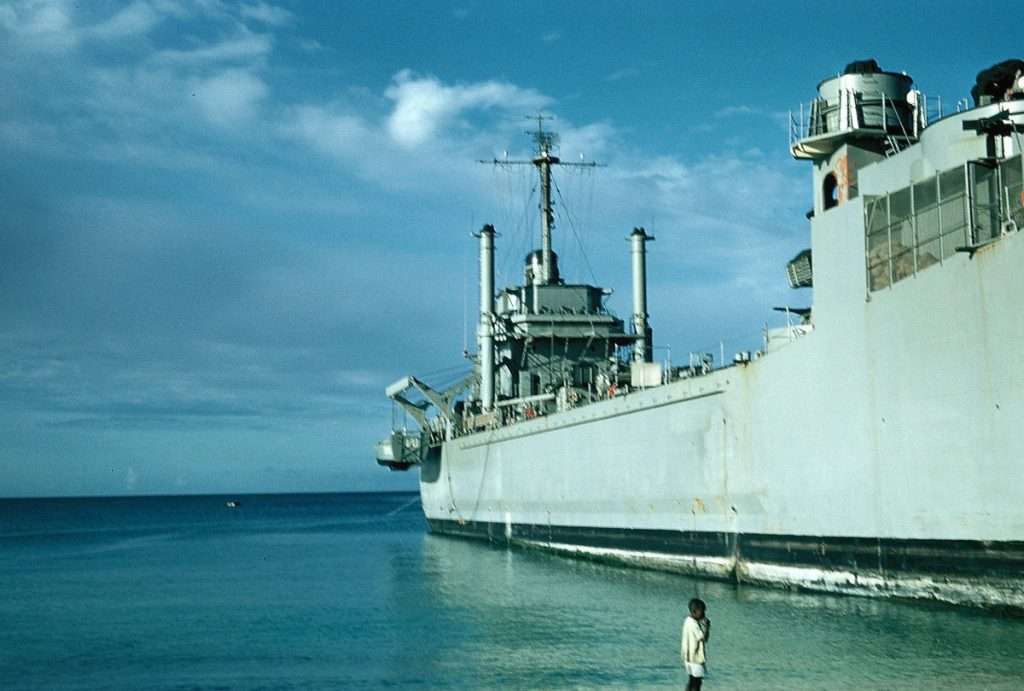
A replenishment Navy Landing Ship, Tank (LST) eventually delivered the “guts” (I can’t even name the equipment) for the Terminal Building and a crew from Western Electric arrived to install it.
Deeper into the project, the ship’s company began to arrive and they could always be spotted by their pale skin colour, crisp dungarees and, in some cases, a look of bewilderment. Upon completion of various companion structures and after nearly a year, we sailed home. Again, security wise, we were told to forget about what we had done and not to discuss it.
Further to this, there was a lighthouse adjacent to NAVFAC 505 and I’ve often wondered how many times “Ivan” climbed the stairs to check us out.
source: A Seabee’s Perspective By Bob Cochrane, Ex-Construction man, USN


How Al Gilkes – story in the Weekly Nation on 18th January 1976 about NAVFAC Barbados alarmed the US Government

This photograph must have been taken post 1966. Notice the sign says Barbados TWI. Pre independence the sign said Barbados BWI.
The following extract is taken from a US Embassy Bridgetown telegram dated 19th January 1976 which quotes an extract from the Weekly Nation of 18th January 1976 (on the street on 16th January 1976) titled “Uncle Sam’s slice of Barbados” which says that the purpose of NAVFAC Barbados was stated with some accuracy as “a land-based electronic eye-spy.” The Nation article was written by Al Gilkes, whose early childhood was spent in the area. His father was the Harrison’s Point lighthouse keeper. What a scoop Al Gilkes!
With hindsight and with the passage of time we now know NAVFAC Barbados was a significant part of the multibillion-dollar SOSUS network of shore based facilities tracking Soviet submarines which was seen as vital to the national security of the USA in the 1950s, 1960s and 1970s.
Below is an exerts from the Nation newspaper article detailed in the US Embassy telegram:
Barbadians in general have hardly shown much interest in matters of a national interest far less those of an international nature. Had it not been for the exposure of Cuban troop movements through Seawell Airport, the reality of what’s going on in Angola would still be as distant as the stars from the minds of the general public.
Not since the days of world war two when a cable was sent off with the now famous words “go ahead Britain, Barbados is behind you,” has anything seemed to alert the attention of thinking Barbadians to the fact that this rock is no longer an island all by itself, but a very real part of the world…
Now Barbadians look at the Angola dispute and ask what action would the United States have taken against Barbados had the Barbados government exhibited sympathy towards the MPLA by turning its back on American demands and continuing to allow Cuba to maintain its shuttle service through Seawell airport?
Similarly what action would an opposing power take against the “friends of all and satellites of none “in the event of a major war with Barbados being sympathetic to the United States by allowing that world power to maintain a naval facility on its shores?
The general public, in its innocent ignorance, is totally unaware of the true significance, in international terms, of the presence in our midst of a segment of the United States’ military might perched on a 100-ft bluff known as the Lion’s head at Harrison point in St. Lucy, the United States naval facility makes Barbados a strategic point of the highest priority in any conflict for world domination between East and West.
It is unfortunate that none in authority have ever deemed it necessary to question the real purpose behind this facility or try to find out what really goes on in this small piece of American, barbed-wire embraced, no-trespassing, plot of St. Lucy land. If the truth was known, the facts could be meat for the most absorbing James Bond thriller of all times.
For, unlike what most people suppose, this is no summer resort for American naval personnel. Rather it’s the United States’ most prized land-based electronic eye-spy in this part of the world.
This is no ordinary Naval base, no outpost in the Caribbean. It’s too small. Its compliment is less than 200 men. No ships dock there, no planes land there. There are no facilities for such activities. The real reason behind the existence of the facility in Barbados is not found in the Administrative building, where daily business routine is conducted: not in the frequent community projects aimed at cementing good relations between personnel and the Barbadian public; not in the employment offered to some jobless Bajans; not in the additional revenue gleaned by the country… It is found in a rather large, maximum security building located at the northern end of the facility, separate from the cluster of other buildings.
Despite its size, access to this two-storied building, commonly referred to as the terminal or “T” building is made possible only through two doors and permitted only to tag-bearing, authorized and specialized personnel, who have been sworn to secrecy. No window decorates the walls. An impassable barbed-wire crowned fence, believed to be electrified and with an electrically operated gate, completely surrounds this awesome structure with its monastic type appearance believed to be equipped with some of the most ultra-modern and sensitive pieces of equipment in electronic development. Vital information collected is fed in and out through a maze of towering antennae which encircle the whole area like a spider’s web, along with a massive underwater cable which is reported to link the base with Miami via Antigua and Puerto Rico.
Here then is the heart of the whole set-up through which communication of every description is detected, collected, monitored, deciphered, decoded, translated and transmitted, if worthwhile, to a higher source.
The facility itself is like a country within a country. Except for the lack of an air or sea port, it is as self-contained as can be, with its own recreational and social facilities including a cinema and a club, its own fuel supply, its own transportation, its own power plant, its own electrical, mechanical and allied services, its own security, its own church, its own economy, its own law and even its own prison.
The fact remains that, as has been previously aired in the Press and otherwise, the existence of such a facility in Barbados must be seen by any power, unfriendly to the United States as a threat, an irritation, a stumbling block and one, in the event of international military conflict, that must be a primary target for immediate obliteration.
The Cuban troop movement through Barbados gave rise to questions about the efficiency of internal security in the context of safeguarding the country from possible invasion. However, no one seems to consider the possibility of invasion from within, generating from the naval facility in the case of some social or political development unfavourable to the United States Government. Obviously the 99-year-lease of life granted to Uncle Sam by Barbados would have been immediately threatened and it is obvious that Uncle Sam would not be willing to sacrifice the advantages of such a strategically-located base as the Naval facility.”
Source: wikileaks: Barbados press on US Navy Base – 19 January 1976 contained in a telegram from US Embassy in Barbados
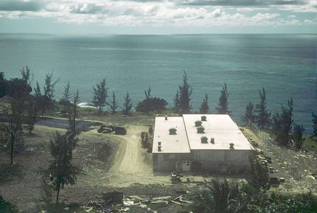
The Terminal Building – where all the secret work was done
The building with no windows, at the north end of the site closest to the sea and closest to the lighthouse was the top secret Terminal Building that housed the listening equipment. It is often referred to as the T building and sometimes the TE (Terminal Equipment) building.
The location of NAVFAC Barbados – Terminal Building (decommissioned: 31st March 1979) is shown below. It is located between Harrison’s Point Light House and what is now Harrison’s Point Medical Isolation Facility, previously the NAVFAC Barbados US base which was operational from 1st October 1957 until 31st March 1979.


We do not have much detail about the specifics of NAVFAC Barbados. However, these facilities were all similar and there is a very good description of the Terminal building in a paper about the Navy Sound Surveillance System (SOSUS) Naval Facility (NAVFAC) – Lewes which we can assume was replicated at NAVFAC Barbados.
What we know from the Seabees that built the Terminal Building in 1956 was when they arrived the large cable was already on the beach. Once the Terminal Building was completed a Navy Landing Ship, delivered the “guts” for the Terminal Building and a crew from Western Electric arrived to install it.
That cable was likely to a “21 quad” cable about three and a half inches in diameter, protected by a split pipe.

In the photograph below of the NAVFAC “Pavilion” located at the foot of the bluff a white pipe believed to contain the array cable can be seen in the background to the right of the building.

The cable would have been connected to hydrophones placed at a depth of 5,000 feet to 6,000 feet close to the “deep sound channel” where the low frequency sound from submarine engines and other machinery could be trapped and relayed back to the specialist deciphering equipment. It is likely out at seas the cable would have been connected to 40 hydrophones which would have been equally spaced in the final 1800 feet “stub” end of the cable.
We have no idea of where the NAVFAC Barbados hydrophone array was located, only it landed near the Terminal building. Based on details from other stations such as NAVFAC Lewes and the cable technology of the the time, our guess is that the NAVFAC Barbados hydrophone array was probably located 100 miles to 150 miles NE of Barbados where the Atlantic shelf changes from 3,000 ft to 5,000 ft.

This is our guess at the location…

As the signals moved along the cable back to the Terminal building, to maintain the “bandwidth” (i.e., the low frequencies of interest) which would be distorted by the capacitance created by the copper wire conductors of the cable, an impedance matching device, known as a “load coil” were spliced into each pair of conductors in the cable. These load coils were inserted about every three miles in order to compensate for the distortion. While each load coil by itself was rather small, due to the large number of conductors (i.e., two wires for each hydrophone; 80 wires or 40 pairs for the 40 hydrophones) the “loading coil packages” which contained the individual loading coils were large. Each package was of the order of 152 feet long and about 2,000 pounds in weight. At NAVFAC Lewes there were 37 of these huge “packages” between the hydrophones and the Terminal building.
What we do not know is how the cable got to Harrison Point? It is possible a Cable & Wireless cable laying ship might have helped. This would have been less obvious to Soviet observers. Cable & Wireless helped lay the cable for NAVFAC Eleuthera in the Bahamas which came on line a month prior of NVAFAC Barbados – so this seems quite feasible.
When the cable entered the Terminal building it went into the Equipment Room where the weak signals it carried were amplified, summed and “formed” into 40 “beams”. Each beam represented the ocean sounds as if they had been detected by a “virtual” hydrophone oriented toward a different small two to five degree sector of the ocean. Thus, the 40 beams represented the sounds from a wide arc of the ocean. These beams were further processed to eliminate signals that represented random noise and to reinforce steady signals. They then went to a “spectrum analyser” to eliminate signals except those in the narrow low frequency bandwidth of interest for submarine detection.
The output of each beam was sent to a separate low frequency analyser-recorder (LOFAR) or “gram writer”. This was a stand with a sloping face on top, over which a roll of specially electrically sensitized paper was pulled beneath an “actuator” into which the electrical signals flowed. As the paper was continually moving forward in time, a stylus in the actuator moved across it on a frequency scale, marking the paper with a black dot to represent each signal, lighter or darker depending on the signal strength. Thus, a constant time versus frequency versus strength graph or “LOFARgram” was continually being created.
Those LOFARgrams would then be interpreted by well-trained Navy Ocean Technicians to detect non-environmental signals that might represent submarine noises. If a possible non-environmental detection appeared on one LOFARgram it was compared to grams from other sectors, analysed for validity based on frequency, persistence, strength and other characteristics. If it were accessed as a possible submarine, it was plotted and the position and characteristics were forwarded to the central processing facility for comparison with information from other NAVFACs.


Some local Perspectives
Here are some tidbits that have been shared with BajanThings:
William Burton worked at C&W in Barbados from 1970 to 1980
During the 1970’s as a junior C&W technician I was stationed at Mount Misery and the US Naval Base fell under our care. I can only add what a technician learned when he was sent there several times to service the UHF (450-500 MHz) radio link back to Mount Misery. I never got anywhere close to the Terminal Building as the radio room with the equipment was close to the main gate. This radio room also had several HF high power Transmitters and a few HF antennas outside including the UHF Yagi antennae on a 30 meter mast.
The system had 2 transmitters and 2 receivers with one pair on line and the other as a hot standby. There were a set of duplexers on each Tx/Rx (Transmit / Receive) pair. This was carried on a 9600 Baud data circuit. After C&W moved from Carrington to Wildey this circuit was routed to Wildey and from there on the Caribbean Tropospheric Scatter network and most likely it terminated at a base in Florida.
In the area of the Terminal Building there were many other antennae systems. All these were moved when the base was closed. The departing US Navy did not even leave the scrap!
There was a small beach with a “beach club” where the off duty personnel could relax with their families. I seem to remember that there was a large pipe going out to the sea from that area. There was a breakwater (parts were still there the last time I visited ) that made a pool for sea bathing.
After the base was decommissioned I visited the area several times, both when walking and for work. I have been into the Terminal Building several times. All that was left was a few empty racks and bits of the suspended floor that cables etc would have passed under. I once found a Red telephone with just a call button. Some people have got bits of Navy stuff like helmets etc. Nothing that will give a clue to what was there!
The building with the radio room was used for several years as part of a radio network. The mast is still there and I spent many hours erecting antennae and installing equipment.
After the land was returned to the Barbados Government the area was used as a Youth Service Camp run by the Barbados Defence Force. It was also used as a temporary prison when the inmates burnt down the old one. It is now a COVID-19 Hospital which is doing very good work.
It is ironic that a lot of the Doctors and Nurses at the Barbados Government COVID-19 Hospital are from Cuba – the same country that was one of the reasons the base was built in the first place.
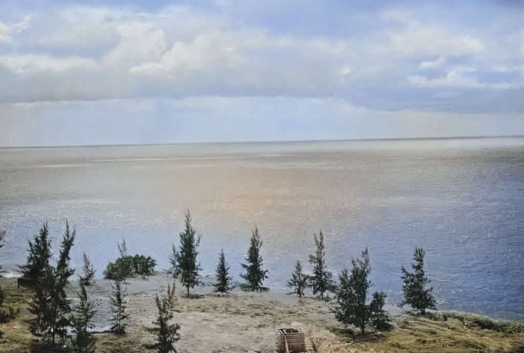
Below are a selection of photos from my archive from 2018


Building Security
It is said that the T Building was armed with phosphorous to cause a meltdown in case it was ever attacked. The naval technicians working within the building would have had about 30 seconds to get out. Those that have explored the building suggest that this might have been the case as there were really wide stairs at one end, much wider than normal, leading from the 2nd floor to the ground.
Someone that actually served in the T Building has confirmed that: “we had thermite bombs in the building for the destruction of classified material. No explosions, just tremendous heat. There were two different sizes and we never tested them. Upon pulling the pins, they were supposed to burn VERY hot. Hot enough to melt the shelves inside the safe in the Crypto vault. Smaller ones were to be used for lower classifications and reacted the same way. We were told that water would only make them burn hotter. Fortunately, we never had the need to use them operationally and we never tested them. We also had a dozen M1’s and a machine gun inside the building for defence/delaying action.”
The story about the Terminal Building being phosphorus armed – might have been embellished along the way in its telling or it might have been a deliberate addition of some misinformation – what’s certain is there had to be a method to protect sensitive material and hardware within the facility.
Undersea cables
Some who have been diving offshore of NAVFAC Barbados area have confirmed that “we do come across cables occasionally. There used to be a big bundle visible near the cliff below the building, but I do not think we can get to that area now. There is also a more modern fibre optic cable that runs through that area.”
Convert Submarine Tracking facility
In addition to NAVFAC Barbados at Harrison’s Point from 1957 to 1979 it now appears there was another hush hush “covert” USA Navy submarine listening / tracking facility located in Barbados between 1953/54 to 1985/87. It appears that this hush hush facility was totally unknown to the Barbados authorities.
For those that knew about this covert NAVFAC facility the cover story which fits with the NAVFAC one, was that this equipment was part of an oceanographic research programme to place Barbados to a fraction of an inch on the map of the world for the new “atomic submarines”.
We have spoken to a number of the older fishermen and shopkeepers at Bathsheba. The cable and the equipment was known about and it was an open secret that it was to do with submarine tracking! Further information on the covert submarine tracking station can be found in the post: Andromeda – the location of a covert US Navy cold-war Russian submarine tracking station in Barbados from 1954 to 1985/87.
Secret US Submarine Dockyard
During the height of the cold war in the 1960s there were some wild rumours that circulated about NAVFAC Barbados. A lot of this was fuelled by mis-information. One of those wild rumours was that submarines came into the base through a hole in the cliff. A bit like something out of Thunderbirds – the classic Supermarionation British science-fiction TV series following the missions of the International Rescue team, a life-saving organisation who had advanced technology to aid them in their rescues. The team’s secret base was on Tracy Island where they kept their fleet of “Thunderbird” machines which would emerge as if my magic.
A secret US submarine dockyard under NAVFAC Barbados was complete fiction and mis-information. We mention it as it’s something that we have seen mentioned on discussion boards about NAVFAV Barbados! Check out the video below – maybe Above Barbados should have used the Thunderbirds Are Go theme music in the background.
Some footage of Harrison’s Point Lighthouse which includes some shots of the NAVFAC Terminal Building. This was filmed on 7th May 2014 by Above Barbados.
https://player.vimeo.com/video/107623203
A visit to the Harrison Point Lighthouse and the old US Naval Base Terminal Building
Jim Webster sent us this:
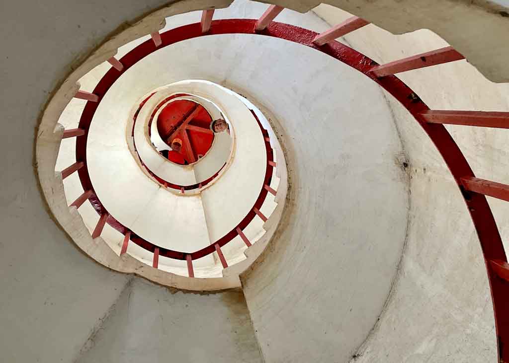
Harrison Point Lighthouse opened in 1925 and ceased operations in 2007. The US Naval Base in Barbados was opened in 1957 and ceased operations in 1979.
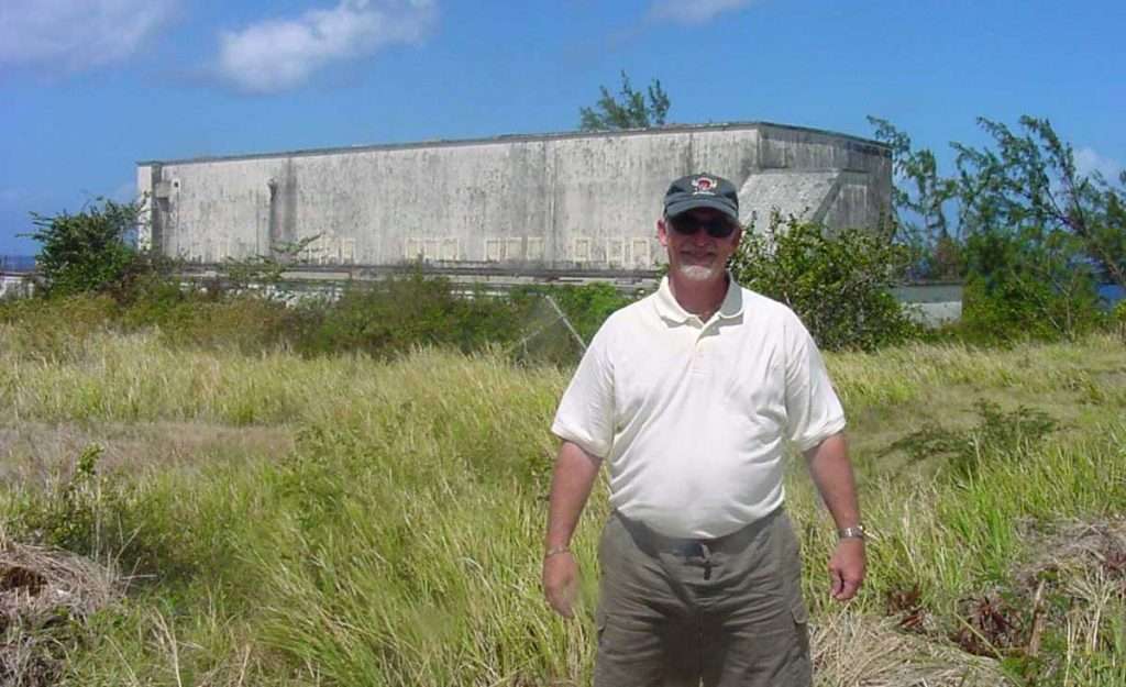
On Saturday 22nd January 2022 three of us headed north to explore some sights including Harrison Point Lighthouse and the old US Naval Base.
Much of the living quarters of the the old US Naval base is off-limits as in 2020 it was re-purposed by the Government of Barbados as its state-of-the-art Covid-19 quarantine and isolation facility.
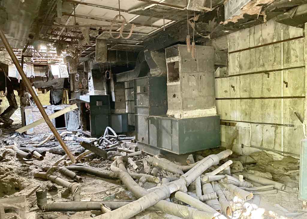
One building, located about 500 metres from the others and now surrounded by bush was what we were interested in seeing – the windowless concrete NAVFAC Terminal Building which was the epicentre of NAVFAC Barbados. The building was surrounded by bush but we were able to access it from two points, both on the lower level. In addition there was a set of exterior stairs that took us to the roof. Entering the building much of the interior ceiling had collapsed with old piping laying about. At the other entrance there was a set of stairs that led to the second floor. This was in total darkness so we were reluctant to explore much further than what we could see from the top of the stairs, remembering the collapsed roof we’d seen on the lower level.
Jim Webster – 24th January 2022


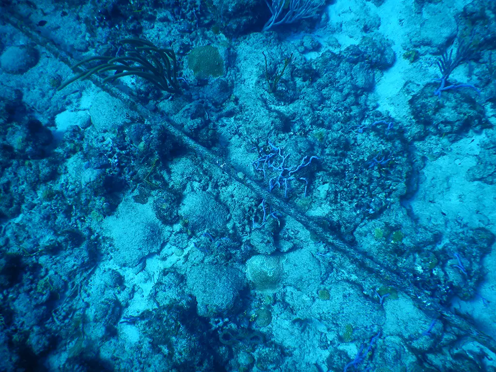
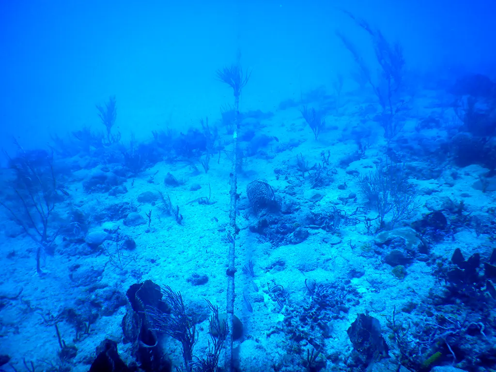
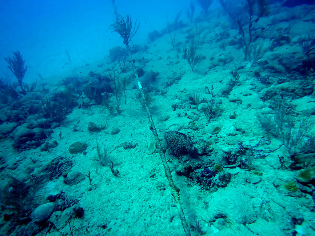
Here are some photographs of remnants of the SOSUS cable at a depth of about 10m on the reef and at about 30m off the reef. These underwater pictures were taken using a Nikon Coolpix W300 underwater camera by James S Webster while diving off the reef north of Harrison’s Point Lighthouse, St. Lucy on 10th August 2024 .
Reference material
For those wanting to learn more about the NAVFAC stations and the science behind SOSUS here are some links:
This YouTube video: SOSUS: The Secret Weapon That Bankrupted the Soviet Union provides the background on how SOSUS provided the USA with information dominance during the Cold War.
It appears there was a second SOSUS station in Barbados. See: Andromeda Gardens – the location of a covert US Navy cold-war submarine tracking station in Barbados from 1954 to 1985/87.
Detailed below few summary docs with good explanations of SOSUS
- https://olli.gmu.edu/docstore/800docs/1003-802-SOSUS%20History.pdf
- https://dosits.org/people-and-sound/history-of-underwater-acoustics/the-cold-war-history-of-the-sound-surveillance-system-sosus/
- https://dosits.org/galleries/technology-gallery/locating-objects-by-listening-to-their-sounds/sound-surveillance-system-sosus/
- https://dosits.org/science/movement/sofar-channel/
- https://www.csp.navy.mil/cus/About-IUSS/Origins-of-SOSUS/
- https://apps.dtic.mil/dtic/tr/fulltext/u2/a468078.pdf
- https://www.usni.org/magazines/naval-history-magazine/2021/february/66-years-undersea-surveillance
- https://hookeaudio.com/blog/news/usas-secret-underwater-surveillance-system-microphones-under-the-sea/
NAVFAC Lewes, Cape Henlopen
- http://www.navyatcapehenlopen.info/sosusnavalfacility.html
- http://www.navyatcapehenlopen.info/navfacterminalbuilding.html
Background on other stations
Wikipedia
- https://en.wikipedia.org/wiki/United_States_Naval_Facility,_Barbados
- https://en.wikipedia.org/wiki/SOSUS
- https://en.wikipedia.org/wiki/Low_Frequency_Analyzer_and_Recorder_(LOFAR)
- https://en.wikipedia.org/wiki/SOFAR_channel
General Background on NAVFAC Barbados site
IUSS/CAESAR Alumni Association
- http://www.iusscaa.org/datafiles/cablenovember2018.pdf
- http://www.iusscaa.org/history.htm
- http://www.iusscaa.org/photos.htm
- http://www.iusscaa.org/coverstory.htm
Wikileaks
- https://barbadosunderground.net/2016/04/18/wikileaks-bridgetown-how-uncle-sam-used-and-abused-little-england-the-ignorant/
- https://wikileaks.org/plusd/cables/1976BRIDGE00103_b.html
Negotiation of bases
- https://history.state.gov/historicaldocuments/frus1958-60v05/d111
- Pat SR Callender book: “Flight Paths & Missing Connections @ Barbados. A Memoir”
Background on missile defence
Bob Cocrane Photos
David I. Kasse Photos
Closure of NAVFAC Barbados – technologically obsolescent