
The LORD is my rock, and my fortress, and my deliverer; my God, my strength, in whom I will trust; my buckler, and the horn of my salvation, and my high tower.
Psalm 18:2, King James Version
Are “these fields and hills” really “beyond recall” as our National Anthem so authoritatively claims? The fields as we know them were formed by man in the 17th century, there must be a record somewhere, maybe not for each one but at least some. Some will say that the hills and the lands on which the fields were formed were formed by God. We can’t pretend to know how He did it, but geologists and palaeontologists can use rocks and fossils and can and do make educated guesses[1] at the truth from the evidence[2] He left in His creation. Others will claim it wasn’t God but the Big Bang Theory, but we would still be in the same boat, we can’t pretend to know how the hills were formed.
Many of the hills are named and some of those names have significance but how would we investigate the origins of the fields that were formed by man? Hills have names like Bissex Hill, Mellowes Hill and Mount Hellaby[3] (corrupted now to Hillaby) and those names originate from early Quakers who owned land in the areas. The hills were there long before them and like us they could not know how they were made, just Who made them.
Like hills in Barbados, every field in Barbados has a name and those names as we have seen in the “Gardens of St. Thomas” do have significance. Source documents such as sworn surveys done of plantations, not easy to come by, will give the associated names of fields. These names were handed down from generation to generation and routinely used just as the name Garden was handed down and used. After time, familiarity with the names bred contempt and the significance of those names was lost on most Barbadians.
- A Survey of Dukes Plantation by C.H. Inniss, 30th November 1934
- Aerial photography of Barbados – 1951
- Colin Hudson et al in the 1960’s and 1970’s
- Some results of georeferencing old and new maps to a coordinate system
- Some place names in the environs of Dukes
- When is a piglet not a piglet?
- Conclusions
- Footnote References
- Other References
- Language Clarification
A Survey of Dukes Plantation by C.H. Inniss, 30th November 1934

Figure 1 – Field list showing names and acreages of fields on Dukes Plantation
This survey is the source document for field names on Dukes Plantation, funnily enough finalized on “Independence Day”, 1934 before there was an Independence Day. Here is the list of field names taken from the survey, (Figure 1). There is a Garden Field marked “P” on the field map on the survey (Figure 2), Negro Yard is marked “V”. Both are adjacent to the plantation yard which is common in many plantations in Barbados. Garden Field is most likely the Burying Ground for the plantation and Negro Yard where slabs lived. Spring Ground is marked “A” on the field map on the survey and borders on the actual spring at Porey Spring”.

Figure 2 – Survey of Dukes’ Plantation, 30th November 1934
There is an “Old Mill” field marked “F” on the field map on the survey as well as a “North Mill marked “D”. Kitchen Field is marked “K” on the field map on the survey. Perhaps there were two mills on the plantation, or two plantations joined each with a mill.
There are surnames which appear in the list. Upper and Lower Brandon, Brandon 1 and Brandon 2, marked “L”, “O”, “G” and “H”, Whites, marked “N” and East and West Pilgrim, marked “Y” and “X”. Pilgrim is not necessarily a surname, it could denote “a person who travels to a holy place as a religious act”. Pilgrim’s Progress was written in1678 by John Bunyan, a Puritan at the height of the Quaker period.
There also is a Prices marked “U” on the field map on the survey and a “Dukes Line” marked “J”. Dukes Line suggests two plantations with this field determining the boundary line. This field can only have been named after 1746 when it was purchased by William Duke. Smith’s Shop marked “Z” could be a surname or it could have been a field next to where the blacksmith on the plantation plied his trade.
Names like Yam Piece and Quarry, respectively “B” and “M” on the field map on the survey denote land use. Spring Ground, Hill, Bridge, Red Hill, Over Gully, Below Wood, Below Hill marked respectively “A”, “I”, “R”, “S”, “T”. “a” and “b” on the field map on the survey denote some physical or geographical feature. Even hills on plantations were named. Perhaps Red Hill got its name because the soil was red as is the case in parts of Barbados.
There is a whole plantation called “Redland”. Cabbage Tree and South Cabbage Tree marked “Q”, and “W” respectively on the field map on the survey denote fields close to cabbage palms.
This system of field names unambiguously identified individual fields as do the various parcel numbers used today at the Land Tax Department. Crop rotation, application of fertilizer, weeding, harvesting etc could all be effectively managed field by field, breaking the larger challenge of managing a plantation of 265 acres and 7 perches into smaller more manageable units. The system[4] was in use in England, but its application across all plantations strongly suggests an overall directing intelligence directed at maximizing agricultural output for the benefit of the country and its people. Quakers were well known for their effective management of businesses as can be seen by googling Quaker Businesses[5].
Aerial photography of Barbados – 1951
At the end of 1950 and in early 1951, the first Aerial photography of Barbados was done, a 1:10,000 paper map was produced in 18 sections (Figure 3) and a coordinate system assigned.


Figure 3 – Snips of Sheet 7 of 18 sheets of the 1:10,000 map sheets with contour lines and a coordinate system
Flight paths from east west and vice versa with a slight northward tilt on the east coast were made. Photographs were taken at intervals to allow for overlap of the images and the extraction of elevation detail using stereoscopic viewing. That technology had been “perfected” in WWII as each side used aerial photo reconnaissance[6] to spy on the other. Today, satellites do the job, photographs are in digital form, and computer software crunches the numbers. An example of the flight path over St. Thomas with its individual photos and overlap is shown in Figure 4.

Figure 4 – One coast to coast flight path over St. Thomas and Dukes
Every individual field in Barbados appeared in the photographs as it was on the day it was photographed in 1950/51. This was before any major development took place in Barbados and so the photographs memorialize not only the state of the land in 1950/51 but also what had existed for centuries. The aerial photo taken over Dukes is shown in Figure 5.

Figure 5 – Aerial Photo of Dukes and other neighbouring plantations
Colin Hudson et al in the 1960’s and 1970’s
Colin was involved in the compilation of a soil map (Figure 6) of Barbados and from that exercise obtained a set of the 1951 aerial photos.


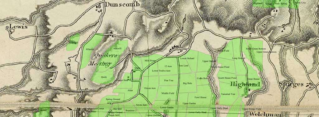
Figure 6 – Sheet 1 of 3 of the 1966 Soil map and environs of Dukes
Colin also undertook a project in the 1970’s with some UWI students to catalog every field in Barbados. They traced the fields of each plantation on to a sheet of paper placed over the corresponding aerial photo, interviewed each plantation’s manager or owner and wrote in the field names, soil type, slope and acreage. They ended up with a field list (Figure 7) for each plantation with selected attributes from the soil map and a corresponding field map (Figure 8) to give the geographic location of the field. Dukes is used as an example.

Figure 7 – Colin Hudson Field List for Dukes Plantation

Figure 8 – Fields from 1951 Aerial Photo of Dukes traced on to plain paper
How did land use/field names change between 1934 and the mid 1970’s when Colin did his field survey? Some fields were amalgamated, and some renamed. The field count fell from 28 to 24 as North Mill, Bridge Ground and Old Mill became a single field, Old Mill. Yam Piece and Handkerchief Corner became a single field, Handkerchief Corner. Dukes Line was joined with Hill Field and became Upper and Lower Hill Field. Negro Yard was renamed Tank Field and Over Gully renamed Old Wall. The two fields, Brandon 1 and Brandon 2 became a single field, North and South Brandon. A comparison between the 1934 survey and Colin Hudson’s work in the mid 1970’s is laid out below in Table 1. Mechanisation explains the creation of larger fields as after the war sugar output rapidly increased to meet increased demand and make up for the destruction[7] of much of the world’s productive capacity in the Pacific, Europe and Russia.

Table 1 – Comparing field names and acreages in 1934 with mid 1970’s.
Some results of georeferencing old and new maps to a coordinate system
The 1951 aerial photo of the Dukes area can be georeferenced to the coordinate system of the paper map and superimposes over the corresponding area or vice versa. The transparency of the top image can be adjusted to allow an inspection of the success of the georeferencing (Figure 9a and Figure 9b). As can be seen the gullies match very well. Roads and cart roads also match well on closer inspection.

Figure 9a – Agreement between roads and cart roads.
The agreement between roads and cart roads on the aerial photos and the 1:10,000 paper map while not perfect is reasonably good and gullies and ridges match well.

Figure 9b – Overlay of 1951 map (1:10,000) on source Aerial photo
Likewise, the 1934 survey of Dukes can be georeferenced to the corresponding aerial photo and superimposed on it and its transparency adjusted. (Figure 10). The fields can be individually drawn and the plantation boundaries inserted (Figure 11).

Figure 10 – Inniss Survey of Dukes of 1934 overlain on 1951 Aerial Photo

Figure 11 – Fields and Field Names inserted to create the database matched to spatial locations to create a Geographic Information System, GIS.
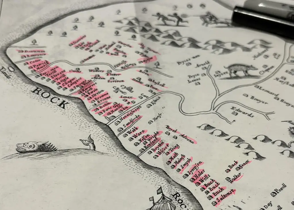
The Mayo from 1722 or Ford 1675/80 can be similarly used (Figure 12 and Figure 13) and then it becomes apparent that some of the field names of the plantation reflect early land ownership. When the plantation boundaries of Dukes are overlain on these two maps some of the field names correspond to families who appeared in the 17th and 18th century maps and that “these fields and hills” are actually not “beyond recall”. Lawrence appears on both the 17th and 18th century maps but not in the field list whereas Brandon from the 18th century, 1722, does.
Old Mill Field possibly reflects the location of Brandon’s plantation yard and North Mill that of Lawrence’s plantation yard. The current plantation yard reflects where Downes’ plantation yard was located. Kitchen Field possibly reflects the existence of Lawrence’s house nearby.

Figure 12 – Dukes boundaries overlain on 1675/80 Ford Map (one plantation, Lawrence, possibly two, Rootsey and Wake)

Figure 13 – Dukes Boundaries overlain on 1722 Mayo (Three Plantations, Brandon, Lawrence and Downes)
Some place names in the environs of Dukes
This article begun with a quote from the Bible for a reason, early Barbadians were Puritans and Quakers fleeing persecution because of their interpretation of the Bible. It seems logical to try to connect place names to religious belief[8] given the close connection of Puritans and Quakers with the Bible and the presence of the Spring Meeting across the gully from Dukes.
Fortress Hill
The Queree Papers gives the ownership of Dukes at the time of the survey in 1934 as follows:
1921 Mrs. J. Rose 181 ac 1929–37 Jean Rose (with FORTRESS) 268 ac The ownership of Fortress at the same time was given as follows:
1921 Mrs. J. Rose 87 ac 1929 See DUKES
The 1934 survey thus includes two plantations and accurately specified the acreage as 265 Acres, 0 roods and 7 perches, an acre or two short of the Queree. Dukes Plantation is an amalgamation of two smaller plantations, one of 181 acres, Dukes, and the other of 87 acres, Fortress.
In 1791, the Queree Papers gave the ownership of Dukes as follows:
1801 9/19 William Duke of St. Thomas, son of Rev. William Duke dec’d, and his father’s executor sells “Dukes” pltn in St. Thomas to Gibbes Walker Jordan of St. Michael for £11,500, 248 ac. Bounders: Gabriel Forde (Spring Farm), Henry Thornhill (Lion Castle), Thomas Cole, Benjamin Williams, Margaret Burrowes, John Drayton, Francis Dorne, William White, Dr. Samuel Forte, Fortress?, Thomas White, Edward Rawlins, The Quakers land, Francis Martin dec’d, James Straker dec’d (Vaucluse), Walter Bennett dec’d (Mangrove Pond)
Fortress Hill as we know it today got its name from Fortress Plantation. Queree puts the earliest acreage at 144 acres in 1831 however, the Barbados Almanac of 1859 in the Shilstone Papers puts the acreage at 86. At the time of the 1934 survey Queree has the acreage at 87 acres.
1791 Dr. Samuel Forte, bounders on Dukes 1815 Nathaniel Forte, bounders on Dukes 1831 26/27 Nathaniel Weeks Forte sells to Charles Frederick Sage, “Fortress” pltn in St. Thomas, 144 ac, £4,551. Sage then sells to Charles St. John
There is some confusion in the acreages in Queree which merits further investigation.
We can see where the field name Whites which appears on the field map of Dukes plantation may have originated but did Fortress Hill really get its name from Dr. Samuel Forte at the end of the 18th century or does the name Fortress correspond with the proximity of the Fortress plantation to the Quaker Spring Meeting across the gully (Figure 13) which existed 100 years earlier?
Psalm 18:2, King James Version: 2 The Lord is my rock, and my fortress, and my deliverer; my God, my strength, in whom I will trust; my buckler, and the horn of my salvation, and my high tower.
The field names, East and West Pilgrim would also fit not as a surname but as a place to which a pilgrimage is undertaken. Other names in the area suggest this is a correct interpretation.
Rock Hall Plantation
Similar logic can be applied to the naming of Rock Hall Plantation in St. Thomas. No field names exist to give us a clue as to the origins of the name, but the psalm can explain those origins, given its close proximity to the Quaker Meeting at the Spring.
“The Lord is my rock, and my fortress, and my deliverer; my God, my strength, in whom I will trust; my buckler, and the horn of my salvation, and my high tower”.
Queree does not have much on Rock Hall in St. Thomas. This is all it has:
St. Thomas – Ord. E. of St. Thomas Church
1783 May 17 BMHS xvi 68 – For Sale, sdg: Benjamin Hole Harper, Thomas Nicell Thorne Mon. Inscript. – belonged to Thomas Harper, now tenantry 1840 (Advocate 84-06-06) – One of 1st black freehold villages
Using georeferenced maps from earlier than 1783 it is possible to say something of its former ownership.
Fire Hill
The hill leading up to Rock Hall and Porey Spring from St. Thomas Church is known as Fire Hill. There are numerous references to hills/mountains and fire in the Bible and Fire Hill lies along one approach to the Quaker Meeting at the Spring.
A quick search by Google of the internet for fire and hills in the Bible reveals this quote: “Primarily fire represents the presence of God, as when Moses encountered God at the burning bush, and later when God appeared in a pillar of fire to lead his people in the wilderness (Exodus 3:2; 13:21). In Acts, the tongues of fire represent the presence of God the Holy Spirit.“.
The Quaker Meeting at the Spring was at the top of Fire Hill and along the way, Rock Hall would be passed. A Biblical interpretation fits the names in the area very well. The naming of the Pilgrim Fields at Dukes also fits into this interpretation.
Content
There was another way up the hill to the Spring Meeting from Holetown via St. Thomas Parish Church, via Content Plantation. This name also fits with the interpretation that it derives from the Bible. Timothy 6:6 But godliness with contentment is great gain.
When is a piglet not a piglet?
Last Sunday William Burton and I went for a walk in the area of St. Thomas where the Quaker Meeting and Burying Ground was located on early maps. It was 25 acres according to a letter from Andrew Dury to a Quaker Meeting in England in the 1760’s.
We talked at length with one resident who had lived for years in the district, and did not know there was a Quaker meeting there.
I called the names of the three fields, Maxwil, Dowrich and Quick and his eyes lit up, he remembered each one.
He told us Quick was where Colin Hudson’s sketches had Maxwil and vice versa so I have switched these fields below.
We wanted to get across the 25 acre plateau and come down in the Porey Spring District so we asked some residents who pointed us to a track called “Piglet”.
No one could tell us the origin of the name. We could not get down and a couple farming on the land pointed out the way, but it was too overgrown, so we went around and found the way up. We came out exactly where we were shown.
We may have passed close to the Meeting without knowing it!!
We came through the Gully from Canefield on the main road and at the top on the west side of the Gully we looked for a way to cross the plateau.
We looked for the spur shown in the 1951 aerial photo which is also shown in Barrallier but there were houses all along the road blocking easy access so we asked. The answer was “You want piglet” as though it was a track to be followed.
No sign of the Meeting Place but it probably would have been at the end of the spur (or along it) on Barrallier so its location can only be determined approximately.
The field, Quick, was under cultivation in 1951 and there would have been a well defined cartroad to follow.
Incidentally, the main road across the gully we followed was “recent” after Barrallier.
The small plantation (circled blue) through which access to the gully and the Meeting was possible was called Darby, sometimes Dalby, and seems to have become part of Canefield in the late 1800’s. Canefield is the unnamed plantation marked above St. Thomas.
The current main road is marked red. Our route up from the Porey Spring side is marked black.

It matches the road/track on the Barrallier, c. 1823.

Pightle – St. Thomas overlayed on Barrallier Map, c. 1823.
Today, I checked the Shorter Oxford English Dictionary for early uses of the word “piglet” and was surprised to find the word “pightle”.
“Odd-shaped fields now caused problems which had not been encountered in the days before mechanization. Thus, over several years, fields were reorganized to be acceptably rectangular. This was cleverly and thoughtfully arranged but, inevitably, there were remnants, leftovers, off-cuts or tailings. In most cases, these were small pieces of land, which were essentially triangular in shape. The locals probably referred to these pieces as “pigtails”. In Norfolk dialect, this would quickly become pronounced as “pightle”. In the 1920’s through the 1940’s,the word pightle was in fairly common usage but has fallen into disuse in recent years.”
Shorter Oxford English Dictionary
Clearly, we found a lot more than we expected.
Without anyone realizing it on Sunday we were shown the location of the Spring Quaker Meeting built sometime c. 1679 and destroyed in the 1780 hurricane, about a century later. The plateau resembles the shape of a pig with the “pigtail” where the field named Quick was located.
Barrallier 50 years later suggests burials resumed after 1780.
Conclusions
These fields and hills are not beyond recall, their names are indelibly written in the land. It doesn’t mean the physical field can’t cease to exist but like us when our time comes their names will have been written on history’s page, even if they have been changed or they cease to exist.
The fields on Dukes Plantation and place names in its environs serve as examples to demonstrate the Biblical thinking behind a field or place name and their place in history. Field names also memorialize early families and speak to land use practices from the past.
Somewhere there will be early surveys of other plantations with their field names but like the work of Colin Hudson and his students they will tell us what we need to know of “these fields and hills”.
The naming convention in the other ten parishes also follows the same Biblical thread as in St. Thomas. Quakers often met in one another’s homes, and it was not uncommon for a Quaker to will his house for the meeting of Friends at his death. Perhaps that is why there are Rock Halls in most parishes.
The Lord has indeed been the people’s guide for the past three hundred years. The Quaker biblical signposts are all there for anyone who takes the time to look and see.
Footnote References
- Job 12:8: “Or speak to the earth, and it shall teach thee: and the fishes of the sea shall declare unto thee.”
- Is Genesis History? – Watch the Full Film – YouTube
- History | Hellaby Hall Hotel
- The Interpretation of the Field Names on English Farms for Archaeological Investigation (archiuk.com)
- List of Quaker businesses, organizations and charities – Wikipedia
- Opération crossbow documentaire bec – video Dailymotion
- What’s Happened To Sugar?, circa 1939-1946 – YouTube
- “A Very Curious Religious Game”: Spiritual Maps and Material Culture in Early America – Commonplace – The Journal of early American Life
Other References
- The Gardens of St. Thomas – Friends’ equality even in death
- The Printed Maps of Barbados 1500 – 1900
- Ronnie Hughes: Barbadian Sugar Plantations Index 1640 – 1846
- Barbados Almanacs: Plantations & Sugar-Works 1848 – 1871
- Handbook of Barbados: Plantations & Sugar-Works 1912 – 1924
- Word of the day – Pightle – Geoff Jones
Language Clarification
This post contains terms that depict ethnic and racial prejudices that were commonplace in society at the time which were used on source documents such as field maps, sworn plantation surveys, wills and other documents of 17th century Barbados. These depictions were wrong then and are wrong today. These terms are presented “as originally written” as to do otherwise would be the same as claiming these prejudices never existed.