
The 1679 Barbados Census – a searchable database
The 1679 Barbados Census offers one of the earliest and most complete snapshots of colonial society in the English-speaking world. It captures land ownership, plantation structure, and demographic patterns at a time when Barbados was the wealthiest colony in the British Empire. For genealogists and historians, it provides essential insights into early family names, migration,…
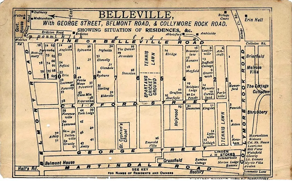
Belleville Village
Belleville was developed in 1885 by Samuel Manning and his brother, Thomas Manning, in partnership with George Whitfield. It was designed as a model residential suburb of Bridgetown, featuring fine homes and nearly 900 Royal Palm trees. By 1890 construction had commenced and by 1898 at least 79 houses had been completed. Some regard Belleville…

The Garrison Drains
The drainage tunnels at the Barbados Garrison are another interesting piece of the puzzle that makes up the history of Barbados. Rediscovered in 2011, during the renovations at George Washington House, the tunnels were unknown to most Barbadians of that time or had become a faded memory by those who may have been aware of…
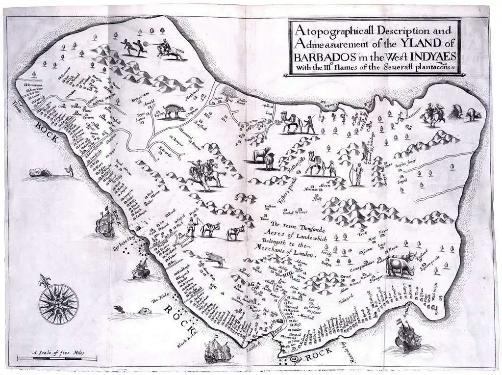
The Printed Maps of Barbados – Part 1: 1500s – 1700
The Printed Maps of Barbados 1500s – 1980s is in 5 sections: 1500s – 1700, 1700 – 1800, 1800 – 1900,1900 – 1980s & Addendums. This is: The Printed Maps of Barbados – Part 1: 1500s – 1700. The follow-on sections are: The Printed Maps of Barbados 1500s – 1980s, brings together the research of…

The Printed Maps of Barbados – Part 2: 1700 – 1800
The Printed Maps of Barbados 1500s – 1980s is in 5 sections: 1500s – 1700, 1700 – 1800, 1800 – 1900, 1900 – 1980s & Addendums. This is: The Printed Maps of Barbados – Part 2: 1700 – 1800. The follow-on sections are: The Printed Maps of Barbados 1500s – 1980s, brings together the research…
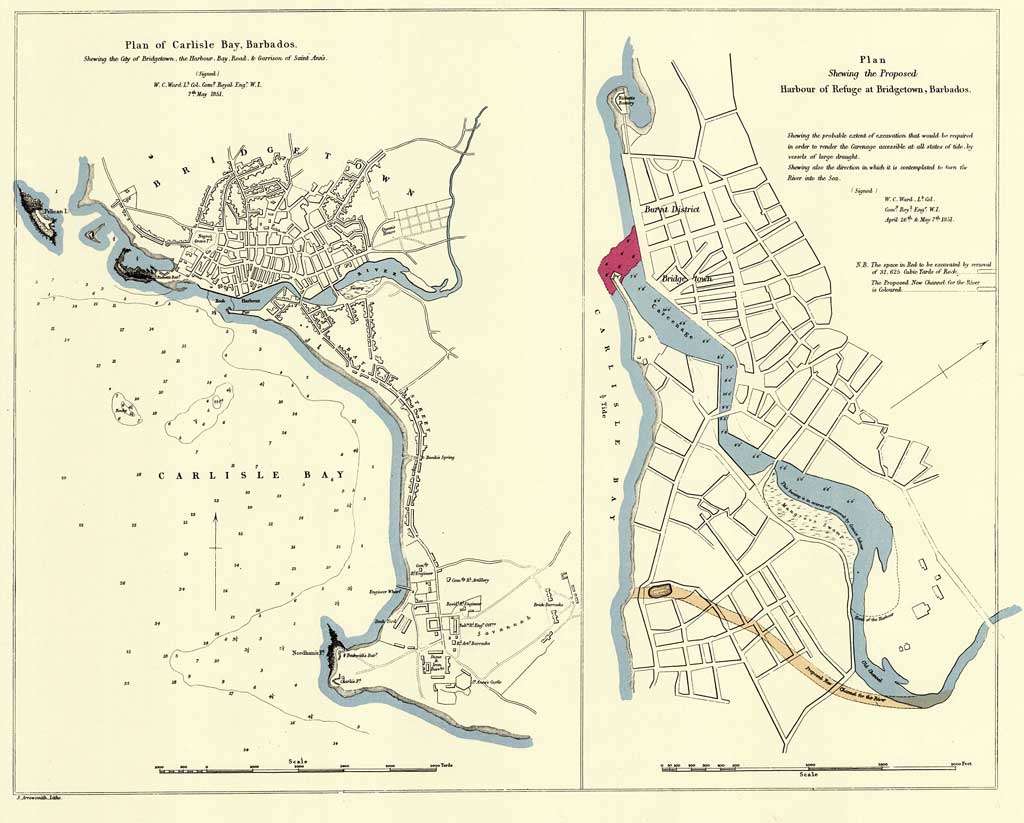
The Printed Maps of Barbados – Part 3: 1800 – 1900
The Printed Maps of Barbados 1500s – 1980s is in 5 sections: 1500 – 1700, 1700 – 1800, 1800 – 1900, 1900 – 1980s & Addendums. This is: The Printed Maps of Barbados – Part 3: 1800 – 1900. The follow-on sections are: The Printed Maps of Barbados 1500s – 1980s, brings together the research…
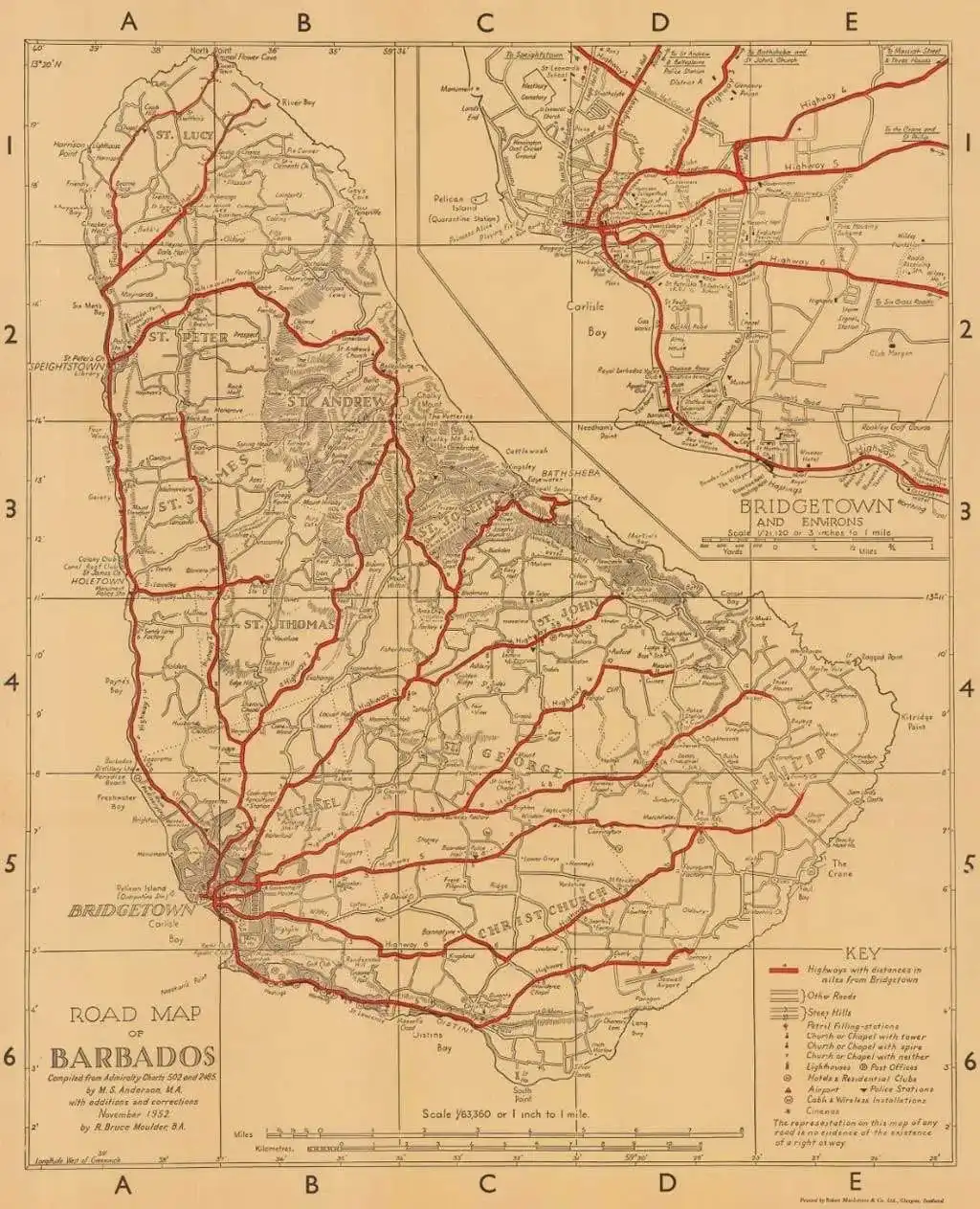
The Printed Maps of Barbados – Part 4: 1900 – 1980s
The Printed Maps of Barbados 1500s – 1980s is in 5 sections: 1500 – 1700, 1700 – 1800, 1800 – 1900, 1900 – 1980s & Addendums. This is: The Printed Maps of Barbados – Part 4: 1900 – 1980s. The follow-on sections are: The Printed Maps of Barbados 1500s – 1980s, brings together the research…

The Printed Maps of Barbados – Part 5: Addendums
The Printed Maps of Barbados 1500s – 1980s is in 5 sections: 1500s – 1700, 1700 – 1800, 1800 – 1900, 1900 – 1980s & Addendums. This is: The Printed Maps of Barbados – Part 5: Addendums. The follow-on sections are: The Printed Maps of Barbados 1500s – 1980s, brings together the research of E.…

Barbados Sugar-Works 1640 – 1924 (Summary)
Jim Webster in collaboration with Francis Ward, has put together three posts for BajanThings all on the theme of Barbados Sugar-Works (Sugar Plantations / Sugar Estates / Sugar Factories). This post brings together the three data tables in one place: In addition Jim Webster has also produced a detailed index of Maps of Barbados going…

Barbados Almanacs: Plantations & Sugar-Works 1848 – 1871
This is the third in our series of stories based upon transcriptions of old plantation sugar-works tables and records. Previously, we published the sugar-works listings from the Barbados Handbooks 1912 – 24 and the Ronnie Hughes Plantation list 1640 – 1846. The latter was previously published on the plantations.bb website which no longer exists. The…
Advertisements

BajanThings
Bajan history. Interesting Bajan people. Hiking in Barbados and Overseas. International Travel…