
Torres Del Paine is a 1800 Sq KM (700 Sq Miles) National Park in Southern Chile. It is approximately 51Deg South which is the same latitude as Vancouver and Cornwall. Just the other side of the equator.

The winter and summer temperatures are colder than the corresponding latitude in the northern hemisphere. However the difference between the mean winter and summer temperatures is less.
Charles Darwin writes about this, and the natural selection of plants that adapt to different climates. His diary is an interesting read. He commends Dr. Bynoe, a Bajan doctor on the Beagle, for the important observations he made on how icebergs transported large rocks from the glacier.
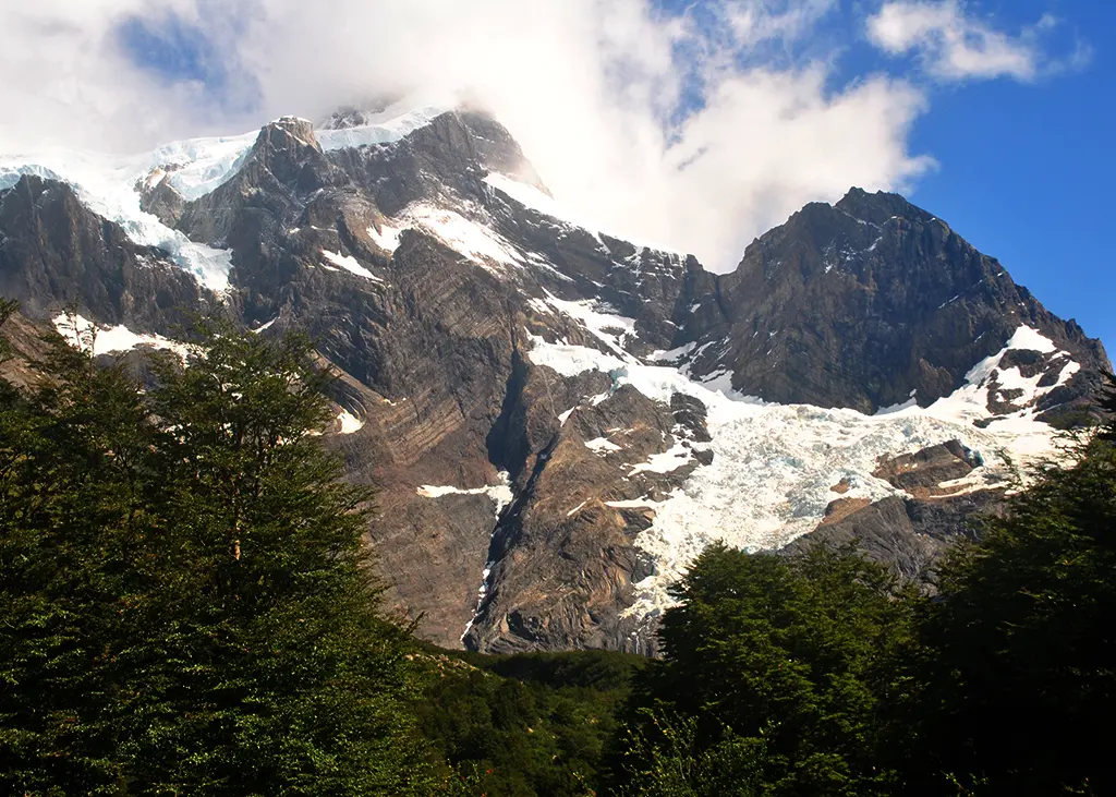
The weather is influenced by the Andean Mountain range, the Hielo Sur ice cap and the cold oceans to the east, south, and west. The mountains rise 2000 meters very abruptly, which makes for a very impressive sight. The ridges are narrow and jagged and the sides very steep.
Before 1959 the lowlands were farmed with cattle and sheep but these destroyed the natural vegetation and wildlife. Since the establishment of the the Torres Del Paine National Park nature is slowly reclaiming the land. The Torres Del Paine Park was declared an international Biosphere Reserve in 1978.
To the north, in Argentina, is the Parque Nacional Los Glaciares and to the south west is The Chilean Parque Nacional Monte Balmaceda. Together these 3 parks provide a refuge for wildlife and plants and a place to enjoy the landscape.
Parque Los Glaciers and Torres Del Paine are on the bucket list of almost every backpacker. I have been fortunate to visit them twice. Both are well cared for, free of litter and waste. They are managed with the emphasis on keeping the land in the natural state and letting nature decide. Wild camping and fires are not allowed. The trail is carefully managed and hikers are forbidden to make their own route.
There are two main trekking routes and a few shorter ones. The W circuit follows the north shore of Lago Nordenskjold, Lago Grey, Valley of Rio Frances and the valley of Rio Ascencio.
The O circuit includes the W circuit but adds in a few more difficult days to Seron, Dickson, Los Perros and Lago Grey via John Gardner pass.
I hiked the W circuit in October 2016 and returned to Chile in January 2025 to hike the Torres Del Paine, O circuit. I opted to do it as a 8 day, 7 night trip through some of the most beautiful and remote country.

After a few days in Calafate, Argentina, I took a bus to Puerto Natales. This was my third visit to Calafate and I received the usual warm welcome at Roble Sur, a family run hotel. It is 10 Minutes walk from the bus station, 15 minutes from the main street and 20 minutes by Taxi from the airport. A very central location but away from the hustle of the town.
Puerto Natales is the hub for hikers, supplies and transport to the Park. The town has many restaurants, accommodation of all levels and outdoor stores, and relies on tourism.
It is a 2 hour, 100 Km, bus ride to Guarderia Laguna Amarga the entrance of Torres Del Paine park to start either the W or O trek. There are also other trails that I hope to explore soon. After registering it is a short shuttle bus to the Welcome Center.
I booked accommodation for the hike and the few nights before and after with Vertice Travel. Vertice also arranged Breakfast, packed lunch and dinner at the campsites. The food was adequate but I usually purchased a few things from the small stores at each campsite.
They also booked the bus tickets to and from the park and the park entrance fees. One less thing for me to do, giving me more time to sample the many beers and wine.
I preferred a tent instead of a hostel type room with several bunks. All were clean and well suited to the constant high winds. They were supplied with a thick and warm sleeping pad and a sleeping bag, but I used my own bag.
I had been studying the Torres Del Paine – Circuit O route for years. The meeting with Vertice the evening before made things a lot clearer and easier. Like bridges that were still in use but in need of major repair, or places that I needed to be extra careful due to the high winds.
Getting first hand information from someone who has “local knowledge” as opposed to someone “on line” thousands of kilometres away made a big difference.
I received the tickets, meal vouchers, maps and my first pack lunch.
Day 1 – Bus to start and walk to Seron 9Km 5 hours
After the early bus to Laguna Amarga and registering with the Guarderia I took the shuttle bus to The Welcome Center. This is actually a souvenir shop. This process was handled very efficiently and quick. They do it hundreds of times each day.
From the welcome center the signs direct you to your destination. The paths are well trodden and marked. There is no need for a map. If there is a junction there will be a sign. Where necessary the route is marked with red or yellow markers.
After the first few Km there were a lot less people on the trail as most hikers do the W circuit or day hikes. I did not see a guide or porter.
The O trail starts over the foothills of Cerro Paine, a gradual climb of about 700 Meters, with good views of Valle Encantado, the mountains to the west and Rio Paine to the East. I saw a lot of them in the next week.
Campamento Seron is situated on a grass plain with a few trees and is close to Rio Paine. The strong tents are raised about 2 meters and give good views of the surrounding country. Seron, and some of the other campsites, are entirely powered by renewable energy.
This camp reminded me of the Serengeti. It is surrounded by flat grassland with a few trees. All that was missing was the sound of the animals.
After a warm shower and a beer while waiting for dinner, it was an early night.
Today was an easy day, a good way to start any multi-day trek. The few river crossings were spanned by foot bridges. The constant wind was just a prelude to the very cold hurricane force winds in the days to come.


Day 2 – Guarderia Dickson 19Km 6 Hours
I had breakfast at 7, collected my pack lunch and was out before 8. The first 30 minutes followed the Rio Paine. After Lago Horseshoe the track made a steady climb through short twisted trees. The wind got stronger and colder as I climbed the switchback trail. It came off Heilo Sur to the North. Largo Paine had white caps usually seen on the ocean.
The exposed narrow single track on the side of a steep slope was difficult. The wind was so strong that I was in danger of being blown over the edge and had to sit and crawl along until I got to an area where there was some shelter from the hurricane force winds. Walking with a backpack was very difficult
I did not have a anemometer but from experiencing 100+ Km/Hr winds in a storm I know it was higher.
Guarderia Coiron, 3 hours after Seron, has picnic tables and toilets. I relaxed here and had lunch. It is a peaceful place.
Sometimes I was the only person on the trail. I never saw anyone for hours. But when I stop a constant flow of hikers pass. Some stay a while, others just sign in and keep going.
After Coiron it was 3.5 hours to Dickson campsite along a winding track through grass land and forest. When crossing the wetlands raised walkways protected the fragile ecosystem. Sometimes the trail was close to Rio Paine. At other times it was higher in the forest.
The ridge that overlooks Dickson camp and Lago Dickson is a moraine that was deposited when the Glacier Dickson retreated. It is another place to take off the pack and enjoy the view.
Dickson is a pleasant camp with a lot of room to relax. A walk to the lake shore is recommended to view the surrounding countryside.


Day 3 – Los Perros 9 Km 5 hours
To Los Perros was through forests, passing waterfalls and deep river gorges of the Rio de Los Perros, named after some dogs that drowned trying to cross. The single track trail winds its way through a bog and a few bridges over smaller streams. The view of Cerro Paine Chico and its glacier gave an idea of what tomorrow will be like. It is very remote country.
A steep scree slope up the moraine created by Glaciar Los Perros gave a view of Lago Los Perros and the Glacier that feeds it. I stayed and enjoyed the view. Just add on another layer of warm clothes! Los Perros campsite is about 20 minutes further on.
Los Perros is a remote camp and getting supplies is difficult. It started to rain and when I arrived and the area around the tents was muddy. It continued and after an early dinner I went to my tent. It rained during the night. Tomorrow will be a long hard day.
The park authorities need to be congratulated on keeping this trail open and the bridges in place. They will constantly need maintenance and some will require that the materials be brought in by helicopter. A very expensive operation.


Day 4 – Refugio Grey via John Gardner Paso 22 Km 12 hours
I left camp before sunrise and for the first few hours followed a very wet trail through a boggy area with short twisted trees. It was over and around some rough terrain following the Rio Paso. This is melt water from the glaciers and snow covered mountains to the north and west. As I got higher the wind got stronger and colder.
After crossing a bridge the forest and low shrubs soon began to thin out and I was soon on black wet rock. To the right was Rio Paso. To the left a smaller stream that originated from the pass that was my destination. The route followed the latter, crossing it several times.
The orange stick markers and paint on rocks marked the route. It was slow going. Everyone picked their own route to the next marker. I tried not to look at the slow moving hikers higher up. They seemed a long way off.
About 3.5 hours after leaving Los Perros camp I made the summit cairn at 1241 Meters. About 800 meters below the peak to the South and about 600 meters above Lago Perros. The rain was almost horizontal due to the wind. Ahead was a very steep and muddy trail with many switch backs and loose rocks down to the Glaciar Grey. But it was hidden in cloud. Today was not a day to stay and enjoy the view.
Glaciar Grey has its origin in the Hielo Sur that covers the southern Andes Mountains. At this point it is approximately 6Km wide and 700 meters below the John Gardner Pass.
After about 2 hours I reached the tree line. This gave some shelter from the wind but the the terrain did not get any easier. The route was steep and wet.
Guarderia Paso has a room to rest before continuing on to Refugio Grey. I rested for a few minutes and had some snacks from my supplies. It was cold so I soon moved on.
Grey Campsite was still 5 hours away. The trail continues about 100 meters above the glacier which was partially obscured by the mist and sometimes light rain. The going got easier apart from a few fallen trees and rivers to cross. I remember getting to one and thinking how will I cross that! But after a few minutes studying it I saw a log and a few rocks and was able to cross safely.
There are 3 suspension bridges to cross deep ravines with fast moving rivers. They are dangerous especially in high wind.
Closer to Grey Campsite the trail improved and foot bridges made the many river crossing easier. These are to facilitate the W hikers going to the lookout point.
I arrived around 5pm. As usual check in was fast and efficient. Dinner and breakfast was buffet style. And you could go back for seconds! A good bar and a warm seating area made it an enjoyable evening. This campsite can easily be supplied from the ferry on Largo Grey and they certainly used it to their advantage.
The 22Km today was not a long hike but it was very slow going. The climb to the pass, although steep and wet, was the easy part. Going down to the glacier was treacherous. It is not a day to be taken lightly. I had a reasonable day weather wise, it could be a lot worse.
When things go wrong
At Los Perros a man was very ill. Luckily for him a doctor was on the circuit and diagnosed his problem. She did not have any medication to administer. A call to the park authorities and it was delivered to Dickson and someone ran it to Los Perros. She stabilized him until the helicopter could come in the next day and take him out. She saved his life.
While this was happening a lady, while crossing the first suspension bridge, was thrown off when it “bucked” in a violent gust of wind. She fell to the ravine and received multiple fractures. Someone going down to help fell and broke his hand and had to walk out.
Park rangers from the Guarderia hut took several hours to get her out and back along the track to Guarderia Paso. There are no medical facilities and all they could do was to keep her warm and wait for the helicopter.
The next day I was in the area and heard a helicopter several times but did not know of the situation and did not see it because of the trees. These attempts failed due to the high winds as a medic could not be lowered. It was not until later in the evening that she was airlifted out to the hospital. Some 24 hours after the accident.
After I crossed the first bridge I met 2 men running with enormous packs. They looked exhausted. They were a doctor and guide and were bringing in medical supplies for her. They came from Paine Grande.
Thankfully, I made it without any issues.
This is not the normal. Every day there are hundreds of hikers on the various trails. Apart from blisters and a few sprained ankles there are very few major incidents.


Day 5 – Paine Grande 11Km 4 hours
The trail was busy with many hikers going both ways. A good track through trees and over a few rivers led to a short, but steep, climb up a rocky path and then a bridge over the Rio Olguin brought me to the first of many vantage points of Lago Grey and the Glaciar Grey. The common feature of the entire circuit is when you reach an exposed location with a good view is strong winds!.
The trail passed Laguna Los Patos in a sheltered valley with good views in every direction.
Paine Grande is a busy camp with a good store, restaurant and accommodation.
The beer from the store is cold and you can sit outside and share the views with fellow hikers.
I was now on the W section and it is a busy area with many hikers doing various routes. The W route has many variations for the start and end and the total distance covered.
The ferry from Paine Grande through Lago Pehoe and then a bus to Puerto Natales is a good option if you have limited time or energy. I think that the vast majority do some variation of the W route.


Day 6 – Refugio Cueros 13Km 6 hours
I went south of Lago Skottsberg, over and around a few hills. Then across a wetland on raised walkways to a bridge across the Rio del Frances and reached Guarderia Italiano after about 3 hours.
I left my pack and walked up Valle de Frances to get a different view of Cerro Paine Grande and its associated glacier.
Then continued on past Refugio Frances and the north shore of Lago Nordenskjold to Refugio Cuernos.
The restaurant and bar were very busy. Some on the first night of their W and others close the end of the O circuit. The restaurant staff were very busy catering to all of the hungry and thirsty hikers who all arrive in in a short time frame. Although they handle it well I am sure that they are glad when we go to our tents.
Cuernos is situated on a steep slope with low trees. A small stream flowed past my tent. The constant sound of the water flowing over the rocks made me sleep very soundly. Or maybe it was the Barbados Rum and Coke with other hikers.


Day 7 – Refugio Central 11Km 5 hours
To Central was a mixture of wooded trails and as I got closer to Central open land with a few bridges over the rivers.
The camp site at Central did not open until after 2 pm so there was no reason to hurry. I enjoyed the contrasting views of the lakes to the south and the mountains to the north and west. It was a dry day with no high winds that I had become accustomed to.

Day 8 – At Central Rio Ascencio
I spent the day walking a short way up the Valley Ascencio and getting my last look at the Torres Del Paine. It is a sight that I will remember for many years.
Central is close to the Welcome Center and a busy restaurant. After a late lunch I got the shuttle bus and then the bus back to Puerto Natales. After 2 nights I returned to Calafate.
It was a very worthwhile 8 days of backpacking through some very rugged and remote country. The weather was good with little rain and the temperature was about 10 DegC at night.
It is possible to do the O in 4 or 5 days by combining some of the days. But why hurry and rush past the views? You will not have time to sit and enjoy the many stunning views or to meet interesting people from many countries.
My daily average was about 2 Km/Hr. This included the many stops to take in the sights. Most of the time I was alone, but very often I joined small groups just relaxing and enjoying the peaceful country. Down hill on the loose steep paths I was slow.
I was very lucky to have good weather for the 8 days with the possible exception of the John Gardner pass. The campsites were well run and the food was suited to the hikers. I did not go there for fine dining.
After 2 nights in Puerto Natales I returned to Robel Sur in Calafate. I went of a Zip line in the hills surrounding the town. It was fast, cold and high. Well worth the experience.


Notes on visiting Chile and Argentina
When entering Chile you will receive from the immigration department a paper document with important information. Keep this very safe in your passport. When you check into a campsite, hotel, national park, bus or any large purchase you will have to produce both. If not you will have to pay some local taxes. When you leave you also have to produce it.
Using US$ in Puerto Natales was difficult. There is an ATM at the bus station and others in town. Credit cards are accepted in every restaurant and on the trail. Argentina and Chile Pesos are not accepted outside their respective countries.
Bus Sur provides a good service between Calafate and Puerto Natales. Book your ticket before you travel and you need to check with the office at the bus station before boarding. They are busy with buses leaving for many destinations and start confirming the booking 30 minutes before departure. You will be given a boarding pass with a seat number. There are other bus companies all traveling the same routes and times. They are comfortable, safe and clean. For the 5 hour ride it will stop at a cafe where you can get a snack. It also stops at both immigration points which are a few Km apart. Do not bring any meat or fruit between the countries.
I found the quality and price of hiking gear in Puerto Natales to be very good. Especially gear suited for a wet climate and cold winds.
If you carry your own tent be sure to get longer pegs than those supplied by the manufacturer. 30+ cm or longer.
Water is available at campsites and the many rivers.
I booked directly with Ventice. They own some of the campsites. If you book with an agent they will pass you over to Vertice, or another local company, after you have paid.
If you need to be connected to the internet purchase a token to use the WiFi at the campsites. This is available at the Welcome Centre. I am not sure about the speed or range from the camp office, but it appeared to work.
It is important that you enter your name, passport number and time of arrival in the log book at every camp and Guarderia station. This may help you, but also the person just in front or behind you if the emergency services are looking for an overdue hiker..
Most of the hikers on the O circuit were in the 25 to 35 age range. There were 2 ladies from the UK over 50. I was the only person over 70!
When you stop doing things purely because you think you are too old it is time to choose your coffin.


Leave a Reply