The Printed Maps of Barbados 1500s – 1980s is in 5 sections: 1500s – 1700, 1700 – 1800, 1800 – 1900, 1900 – 1980s & Addendums. This is: The Printed Maps of Barbados – Part 5: Addendums. The follow-on sections are:
The Printed Maps of Barbados 1500s – 1980s, brings together the research of E. M. Shilstone, Tony Campbell, Alan Moss and Jim Webster.
E. M. Shilstone published “A Descriptive List of Barbados Maps” in 1938 in the fifth issue of the Barbados Museum and Historical Society (BMHS) Journal. Eustace Maxwell Shilstone a Barbadian lawyer co-founded the Barbados Museum & Historical Society (BMHS).
Tony Campbell authored “The Printed Maps of Barbados” in 1965, (Map Collectors’ Circle, No. 21). This was a key resource and inspiration for this project despite being out of print.
Alan Moss contributed “Further Notes on The Printed Maps of Barbados” in BMHS Journal volumes XLI (1993) and XLV (1999).
With digital libraries now widely accessible, Jim Webster has expanded on their work, further enriching the collection of printed Barbados maps.
Sourcing Missing Maps, Additional Maps And Map Images
If you can help source images of any of the maps where there is no image or would like to suggest maps of Barbados that should have been included in “The Printed Maps of Barbados 1500s – 1980s” please contact me by either leaving a comment below or clicking on the BajanThings Contact Burts link and choosing from the Subject drop-down: “Barbados Maps – Forward to: Jim Webster”.
Jim Webster – 15th February 2020 (updated February 2025)
Addendums to old, historical and antique printed maps of Barbados
This rapid development can be seen recorded in the early maps of the Island. Ligon’s map [No. 1, see plate I] made about 1650 is a sketchy affair showing plantations along one side of the island only, because at this time there was still thick forest over the remainder. By the time of Ford’s survey [No. 8, see plate V] made between 1676 and 1680 almost the entire island had been brought under cultivation.
Barbados’ other peculiarity is that it was first settled by the English and has remained a British possession ever since. Barbados is very proud of this fact. In 1813 in Trafalgar Square, Bridgetown, a statue of Nelson was erected, the second to be raised to his memory in the Empire. It also has an established Church and to this day the administrative divisions of the island are the eleven parishes set up in 1645.
Of the early history of Barbados we can learn more from maps than from the printed accounts. The earliest written mention of Barbados appears in the Instructions which Charles V sent, in 1518, to Figueroa in Hispaniola to ameliorate the condition of the mine-working Indians from Trinidad and from “la lsla de los Barbudos.” From manuscript maps, however, we can see that Barbados was known to the Spaniards at least 10 years before this. The world map drawn by Columbus’ pilot Juan de la Cosa in 15003 (though probably added to until 1508) shows that the Spaniards had a fairly clear idea of the general line of the Antilles. The Cantino world map of 1502 testifies to the Portuguese being less advanced in their knowledge of the West Indies as it only shows the Northern Antilles as far as Guadeloupe. This omission of the islands between Tobago and Guadeloupe was common on printed maps until the later sixteenth century.
The first named instance of Barbados appears in the Egerton M.S. map in the British Museum.4 It was based on Portuguese or Spanish information and is thought to have been made in 1508. These manuscripts, maps and charts were zealously protected from the gaze of foreigners who might have used the Information to upset their trade empires in the New World.
It was not until 1544 in a mappe-monde ascribed to Cabot5 and published probably in Belgium or Germany that Barbados first appears on a printed map, as ‘Ya del: Bernaldo.’
Barbados has been variously named; on the earlier maps it appears as, St. Bernardo, Bernados, Barbudoso, Baruados, Barnodos, etc. and to this variety is added the confusing presence, just to the north of Antigua, of another island, Barbuda, whose similar sounding names have often been indistinguishable from those used to denote Barbados. On Coronelli’s map, “Archipelague du Mexique” (c. 1690), Barbados is labelled “Is. Barbados ou Barboude et la Barbade”, while Barbuda is “Barbuda et 1. Barbada ou I. Barboude” (see Plate XXV). In view of this linguistic uncertainty it is not surprising that during the early proprietary struggles the case could be put forward, and legally upheld that the other island had been referred to in the grant of title, and not Barbados at all.
The derivation of the name is obscure; some maintain it is in honour of St. Bernard, others that it is the Portuguese or Spanish word for beard, a reference either to bearded Indians or to an indigenous species of fig-tree whose downward plunging roots seemed like a beard. The Egerton map calls it La Barbata (and the other island simply Barbata) which suggests that the latter theory is more probable, and the St. Bernardo merely a pious alteration later, popularised by Ortelius, Mercator, Blaeu, etc.
During the sixteenth century Barbados must have been often visited by the Portuguese on their way to Brazil and the Spanish ships plying between Hispaniola and Trinidad. The hogs which were found by the first settlers running wild all over the island were supposedly left there by the Portuguese as a surety against starvation should they be wrecked there.
According to Purchas Barbados was first visited by the English in 1605, “Sir Oliph Leagh, a worshipfull Knight of Kent, sending a supply of good numbers of men in a Ship called the Oliph blossome . . . we were faine to touch first at the Isle of Barbudos, and then at Santa Luzia in the West Indies.”6 This occurs in an account by John Nicholl, but since he did not mention Barbados in his original version of this,7 published some years before, we must doubt it.
They did not settle and it was not until 20 years later that one of the Dutch ships licensed to trade with Brazil landed there and took back a favourable account which was passed on to Sir William Courteen, a London merchant. It would perhaps be as well to describe here the nature of the island they found. It was 21 miles long and 14½ broad, or roughly the size of the Isle of Wight. Encircled by coral reefs there was only one natural harbour – Carlisle Bay – but it provided adequate shelter for many ships. Inland was dense forest populated only by hogs running everywhere wild. The native population had been carried off to the Spanish mines. The climate was mild. It must have been an attractive prospect and after one of Courteen’s own ships had landed there about 1624 and confirmed this, in 1627 he mounted an expedition and, sending out between 40 and 80 settlers (accounts differ on this as on most other significant details) landed them at “the Hole” (now Holetown). In the same year Charles I rescinded the original agreement which had promised the Island to Courteen and granted Letters Patent to Lord Carlisle of all the “Caribee Islands.” This was the beginning of the proprietary struggles that were to mar the first 35 years of the Island’s history. Carlisle, a spendthrift, leased 10,000 acres to some London merchants, which Ligon records on his map (see No. 1, Plate 1) “the term Thousande acres of Lande which Belongeth to the Merchants of London.” They sent out as first Governor, Charles Wolferstone, who arrived in 1628 with about 70 settlers and, landing at a place where there was an old Indian bridge over a stream (later to become Bridgetown, the capital) established himself in opposition to the rival faction at Holetown, and the stalemate was only ended when Carlisle sent out another man with sufficient force to command authority.
In 1639, from diplomatic rather than democratic motives, a Parliament was set up, the second oldest in the Empire. During the Civil War, the Island, under its Governor, Lord Willoughby, declared for the King. (The English) Parliament sent out a punitive expedition which forced a surrender though on terms that guaranteed the Island’s rights. At the Restoration the settlers’ fears about the illegality of their land titles were set at rest by the reversion of Barbados to the Crown, but the price of this was a 4½% tax on exports, only revoked in 1838.
Barbados has always been an English possession, but in 1665 it was very nearly lost to the Dutch admiral, de Ruyter. Thereafter, and more particularly after the first English soldiers arrived in 1695 at the Island’s request to mount a garrison and build a chain of forts round the coast, the only threats came from taxation, the disruption of their export trade in times of war, the fires which periodically destroyed Bridgetown and the inevitable hurricanes.
For the rest the Barbadians could meditate on the qualities of sugar: “As rich as a Barbados planter”, was soon a simile for Croesus in England, and one eighteenth century authority even credited it with health-giving powers,
If Sugar can preserve both Peares and Plums, Why can it not preserve as well our Lungs?
This check-list owes a considerable debt to E. M. Shilstone, whose “A Descriptive list of Maps of Barbados“, published in 1938 under the authority of the Barbados Museum and Historical Society, mentions two maps which are not included here as there is insufficient proof that they were ever published:
The first is cited on the evidence that in 1792 the Barbados Legislature licensed the publication of a map by Ely Leach, Surveyor.
The other is a map by William C. Hope of Bridgetown, advertised for sale in the Barbadian Newspaper of October 11th,1834. There is no trace of either of these maps.
Preface footnotes:
1 Ligon (R.) A True & Exact History of the Island of Barbados, 1657.
6 Purchas, Hakluytus Posthumus or Purchas his Pilgrimes. 1625.
7 Nichol] (John) An hour-glasse of Indian Newes, 1607.
BARBADOS and sugar are two concepts inseparable to anybody not born a Barbadian and there is a long tradition behind this. When Richard Ligon arrived on Barbados in 1647, only 20 years after the first settlement he found “that the great work of sugar-making, was but newly practised by the inhabitants there.”1 In fact the ship which had dropped the first settlers carried on to Guiana where various plants considered suitable for the island were collected and with them the Indians to instruct the settlers in their cultivation. Among these was the sugar cane. “At the time of our arrival there,” writes Ligon, “we found many Sugarworks set up, and at work; but yet the Sugars they made, were but bare Muscavadoes, and few of them Merchantable commodities; so moist, and full of mollossos, and so ill-cur’d, as they were hardly worth the bringing home for England.” But by the time he left the Island in 1650 he could report that, “this commodity, Sugar, hath gotten so much the start of all the rest of those, that were held the staple Commodities of the Iland, and so much over-top’t them, as they are for the most part slighted and neglected.”2
byTony Campbell 1965
The authoritative guide to Barbados” printed maps is Tony Campbell’s 1965 publication in the Map Collectors’ Series, The printed maps of Barbados and in its preface Campbell acknowledged his “considerable debt” to E.M. Shilstone’s “A descriptive list of maps of Barbados” which appeared in the Society’s Journal in 1933 (actually 1938). During the course of research on the smaller of the two Bellin maps of Barbados (Campbell, 34 – 35) the results of which were published in the 1993 issue of this journal, I became aware that while Shilstone and Campbell, and especially the latter, provide a very considerable body of information on the subject, not surprisingly there are still additions, refinements and corrections which can be made, to their findings. During the past five or six years. therefore, I have made an effort to examine as many as possible of the maps recorded in Campbell with a view to corroborating or, where the evidence wants it, revising the descriptions given. It should be noted that my approach to this study has been primarily cartobibliographical, i.e. my purpose has been to establish and record the facts of publication surrounding these maps; the information provided in the maps has been of only peripheral interest.
In this article the maps recorded at Campbell, 1- 33 are considered. Since Campbell provides the bedrock for this research, the numbers and headings assigned to the maps in his work have been retained and indeed the intention is that the article be read in conjunction with Campbell’s work.
The assistance and encouragement which Tony Campbell has invariably offered when I have been able to meet with him in the British Library’s Map Library, where he is Map Librarian, is most gratefully acknowledged.
In addition to the British Library’s, collections consulted during the course of this research have included those of the Library of Congress; the Bancroft Library; the Main Library, University of the West Indies, Cave Hill Campus; and the Barbados Museum and Historical Society. Particular mention must be made of the John Carter Brown Library at Brown University, however, where for two weeks in May 1996 I was privileged to secure an attachment as a Library Fellow. The depth of that library’s resources ensured that the time spent there was extraordinarily productive.
Alan Moss – Journal of the Barbados Museum and Historical Society – Vol. XLV
SELECTED: List Of Dates
1508 First named appearance of Barbados, on the Egerton M.S. map
1518 Charles V’s Instructions to Figueroa about the condition of the Indians from “La Isla de los Barbudos”
1544 Cabot mappemonde. First appearance of Barbados on a printed map.
1605 An English ship, the Olive Blossom, forced to land
1624 Visited by a ship belonging to Sir William Courteen
1627 Another of Courteen’s ships lands the first settlers at “the Hole”
1628 Wolferstone comes out as first Governor and establishes a rival settlement at Indian Bridge (later Bridgtown)
1639 Parliament set up
1645 Island divided into 11 Parishes
1647 Richard Ligon lands on Barbados
1650 Royalist Lord Willoughby, Governor. Parliament sends out an expedition
1665 De Ruyter fails to take the Island
1676-80 First survey of Barbados by Richard Ford
1695 First English soldiers come
1717-21 Mayo’s survey
1730 Printing press set up
1780 Worst hurricane in Barbados’ history, 4,000 killed
1869-73 First modern survey, by the Admiralty
INDEX TO: Map-Makers, Printers And Engravers
The numbers relate to the map reference number (No. #).
Admiralty: 50, 54, 59, 62, 63, 64
Lodge: 43
Baldwin: 42
Lopez: 39
Barbados Railways: W[1877-1937]
Lucas: 51
Barbados Society of Technologist in Agriculture: W1986]
Atlas maritimus, or, A sea-atlas : describing the sea-coasts in most of the known parts of the world / by John Seller, hydrographer to the King Yale University Library
REFERENCES: A. Moss
Campbell, Tony. The printed maps of Barbados. London: Map Collectors’Circle, 1965. (Map collectors’ series, 21).
Shilstone, E.M. “A descriptive list of maps of Barbados.” Journal of the Barbados Museum and Historical Society 5 (1932/3): 57- 84.
Moss, Alan. “Notes on two of the early printed maps of Barbados. ” Journal of the Barbados Museum and Historical Society 41 (1993) :
Wing, Donald, comp. Short-title catalogue of books… 1641-1700. 2nd ed. …New York: Modern Language Association of America,
Van Eerde, Katherine S. John Ogilby and the taste of his times. Folkestone: Dawson, 1976.
Black, Jeannette D. The Blathwayt atlas. Volume II: Commentary. Providence, RI: Brown University Press, 1975.
Black. Idem.
Tyacke, Sarah. London map-sellers, 1660-1720 : a collection of advertisements for maps placed in the London gazette, 1668-1719, with biographical notes on the map-sellers. Tring, Hens: Map Collector Publications, 1978.
Tyacke. Idem.
Phillips, Philip Lee, comp. A list of geographical atlases in the Library of Congress. Vol. I : Atlases. Washington, DC: Government Printing Office, 1909.
Sabin, Joseph. Bibliotheca Americana: a dictionary of books relating to America from the discovery to the present time. 1868-1936. New York: Miniprint Corporation, [1966]. 2 vols.
Phillips. Op. cit.
ADDENDUM: A. Moss – Bellin Maps No. 34 & No.35
Detailed below is the Alan Moss description of the Bellin Maps No. 34 & No.35 which was subsequently published by the Journal of the Barbados Museum and Historical Society Vol. XLI 1993.
NOTES ON TWO OF THE EARLY PRINTED MAPS OF BARBADOS Alan Moss (Transcribed by Jim Webster January 2020).
THE SMALLER “CARTE DE I’ISLE DE LA BARBADE”, by J.N. Bellin
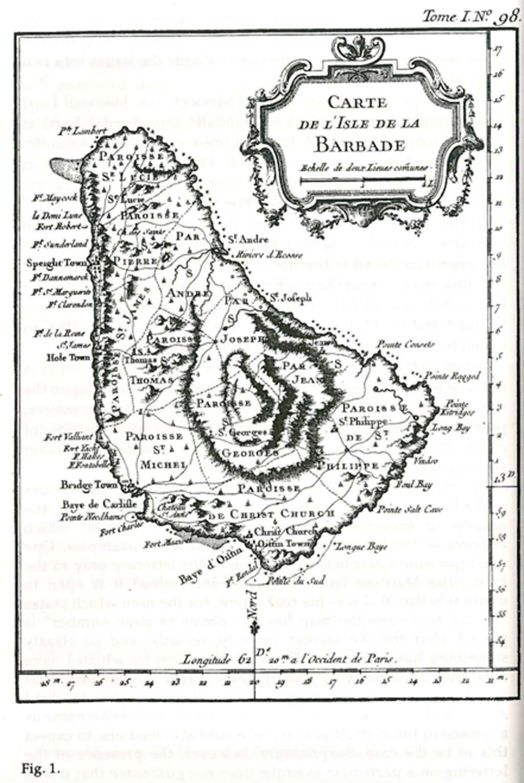
The entry in Tony Campbell’s The printed maps of Barbados for the smaller “Carte de I’Isle de la Barbade” by Bellin, item 34, reads:34 1758 BELLIN (].N.) Carte de I’Isle de la Barbade. 15 x 19½ cms.
In: Description Géographique des Isles Antilles possédées par les anglois. Paris, Didot, 1758.
In: Bellin (].N.) Petit Atlas Francois Receuil de cartes et plans des quatre partie de monde (Vol. 1) 1763-4. (In this first issue the map has no volume or page numbering.)
Another issue: Lettered Tome 1. No. 98. In Bellin: Petit Atlas Maritime (Vol. 1) 1764.
Another issue: “Pour servir a I’Histoire Générale des Voyages”, added beneath the title. Along the bottom Tom. XV in 4° No. 17 and Tome 15 in 8”, page 567. In: La Harpe (J.) Abrégé de I’Histoire générale des voyages, 1780.
And the entry for the closely related item at 35 reads: 35 1758-[81] BELLIN (J.N.) Carta dell’Isola della Barbada. 15 x19½ cms. [Venice, 1781.]
I . In: Teatro della guerra maritima, Venezia, 1781. (The map completely re-engraved, with the place names mostly in Italian.)
The simultaneous acquisition of copies of two of these variants afforded me the opportunity to compare them closely, and the small but significant differences which were observable between them prompted the desire to be able to document more fully the publishing history of the map, which in its several forms is perhaps the most common of the early printed maps of Barbados. A significant part of this research was carried out in the British Library, where Tony Campbell is Map Librarian, and I wish gratefully to acknowledge the encouragement and advice he offered during my visit to London in 1991. I find that three further French issues can be identified, which in an approximation of Campbell’s style of entry can be described as follows:
In: Prévost d’Exiles, Antoine Francois. Histoire générale des voyages… Paris, Didot, 1746-1770. 20 vols., in 4° Lettering at bottom: Tom. XV. N° 17.In Vol. 15, published in 1759.
In: Prévost d’Exiles, Antoine Francois. Histoire générale des voyages… Nouvelle édition. La Haye, P. de Hondt, and Amsterdam, E. van Harreveldt and D. J. Changuion, 1747-1780. 25 vols, in 4°. (Vols. 1-18 published in La Haye, vols. 19-25 in Amsterdam.) Lettering at top right: Tom. XXIII. And at bottom: A.V. Krevelt, Sculps. Amsterd. 1777. In Vol. 23, published in 1777.
In: Prévost d’Exiles, Antoine Francois. Historie générale des voyages… Paris, Didot, 1748-1789. 80 vols., in 16mo. Lettering at bottom: Tom. XV. N° 17. In Vol. 60, published in 1759.
The following German issue was also encountered:
Karte von der Insel Barbade, zur allgemeine Geschichte der Reisen.
In: Schwabe, Johann Joachim. Allgemeine Historic der Reisen zu Wasser und Lande… Leipzig, Bey Arikstee und Merkus, 1747-1774. 21 vols., in 4°.
Lettering at top: N” 17. And at bottom: XVII Band T.17.F.
(The map completely re-engraved, with many place names in German.) In Vol. 17, published in 1759.
The most revealing of the differences to which reference was made above concern the accuracy of the maps with regard to the placing of Maxwell and Kendall Forts and whether or not the St. John / St. Philip parish boundary is shown, for an examination of these two characteristics enables us to divide the issues into two mutually exclusive groups.
In one type, the position of “Fort Maxwel (i.e. Maxwell Fort) is accurately shown and “Fort Rendall” (i.e. Kendal Fort) is similarly correctly located. In all of these cases the St. John / St. Philip parish boundary is omitted. The first three issues in Campbell’s entry 34 are the only ones which fall into this category. (For an example of this type, see Fig. 1.)
In the second type, which extends to all other issues I have been able to examine, Maxwell Fort under the name “Fort Maxuel” has been transposed to the site of Kendal Fort, on the Enterprise coastline overlooking Oistins Bay, with the name of the latter fort being omitted from the map entirely. The parish boundary between St. John and St. Philip is present in all of these issues. (For an example of this type see the La Harpe issue at Fig. 2.)
Given that each is accurate in a respect in which the other is not, it is apparent that neither type can have been based upon the other. Each must therefore have relied upon some other source, presumably Bellin’s original work. One can also deduce, of course, that in both cases the engravers erred, although in different ways, when transcribing that work to the plate.
The only feature which serves to differentiate the three issues in the first group from each other is that noted by Campbell, the absence or presence of the lettering “Tome I. No. 98” which appears in the top right hand margin in some examples. One must question Campbell’s ascription of the lettering only to the Petit Atlas Maritime issue, however, and indeed it is open to doubt whether this was his true intent, for the note which states “In this first issue the map has no volume or page number” is placed after the the second issue he records, and so clearly something has gone awry. Certainly those copies which I have been able to identify as having been issued in the Petit Atlas Francois do bear the lettering, as well as those issued in the Petit Atlas Maritime. Tooley’s description of the Petit Atlas Maritime as a reissue of the Petit Atlas Francois would also lead one to expect this to be the case. Surprisingly, however, the presence of the lettering on a particular example does not guarantee that it was issued in one or other of the two atlases, for the maps in the University of Texas Benson Collection’s copy of Bellin’s Description geographique des Isles Antilles carry the lettering, inappropriate though it is in that publication.
There seems to be nothing to suggest that these variants were not produced from the same plate, and they may indeed therefore be regarded as issues of the same map. The six variants which we have identified as comprising the second group, those which correctly record the St. John / St. Philip boundary but err with regard to the forts, were all published in editions of the Abbe’ Prévost’s Histoire générale des voyages or works derived in part from it, and while the necessity to engrave new plates for the Italian and German issues can be readily understood, the a priori expectation would be that the four French issues in this group would have been issued from the same plate, given the reluctance of publishers to incur the expense of re-engraving a map when an existing plate could be used. Although the two Didot editions do seem to be from the same plate, however, a significantly wider plate mark (approximately 171 mm as against the 158 mm of the Didot issues and the 161 mm of the de Hondt edition) distinguishes La Harpe from the others in the group, and the path taken by what is now Highway 6 through the word “Phillippe”, among other things, demonstrates that the Didot and de Hondt maps came from different plates.
And indeed, a knowledge of the reasons offered for the publication of de Hondt’s edition of the Histoire générale des voyages so soon after the appearance of the original makes it very apparent why in this case new plates needed to be cut. Seeking to throw doubt on the faithfulness of Prévost’s translation of the English sources from which the earlier part of the work is drawn, and indeed on the good faith of Prévost himself, the de Hondt edition went to great lengths not only to reproduce its own translation of matters omitted by Prévost but to mark them in the text, and to indicate what had been added to the original by Prévost. The publication of the two editions over a number of years afforded the opportunity for attack and counter-attack through “avertissements” in the early volumes of the work, with Prévost dismissing the Dutch edition as one in which “j’ai refusé de prendre part, & que je desavoue”. In the circumstances Didot could hardly have been expected to make its plates available to de Hondt.
It is apparent, then, that it was from the Didot plate that the earliest examples of this second type were produced, and that all other plates of this type were copied from it, either directly or via an intermediary. Since the earliest issue of the first type, in Bellin’s Description géographique des Isles Antilles, also emanated from Didot we are forced to address the question of why it should have been found necessary to engrave what we may assume were intended to be two identical plates of the same map within’ a year or so of each other for use by the same prlnter.
The answer may lie in the status of the Description géographique, which was published “Par ordre de M. Le Marquis de Massiac, Lieutenant Général des Armeés Navales”, and is regarded as an official publication of the Depot des Cartes et Plans de la Marine. It seems plausible to suggest that the official nature of the publication may have limited Didot’s right to use the material it contained, necessitating the production of a second plate which could be used commercially.
Other editions of the Histoire générale which might have been expected to include further issues of Bellin’s map are the Madrid edition”, the Dresden edition“ and the Dutch translation which de Hondt published. I have found no evidence that any of them does so, however. Although some authorities ascribe an atlas to the Madrid edition Sabin, for instance, does not, and the apology in’ the Pro’logo to that edition for the absence of maps and illustrations, even though qualified by the hope that they may be published at some future date, tends to support his view. The Dresden edition does not appear to have progressed beyond vol. 16 despite the publisher’s stated intention that it should, and therefore does not include a section on the West Indies; and the Historische Beschryving der Reizen, as Sabin notes, was a translation of the first 17 volumes only of de Hondt’s French-language edition, and again, therefore, does not treat of the West Indies.
If a list of the printed maps of Barbados should accord a separate entry to each plate from which maps have been pulled, then six entries are needed to encompass the variants that have so far been identified of the smaller Bellin: one to cover the first three issues listed at item 34 in Campbell; one for the Italian issue listed in Campbell at 35; one for the two Didot issues of the ‘ Histoire générale des voyages; and one each for the Schwabe, de Hondt and La Harpe issues.
1758 Jacques-Nicolas Bellin Barbados Museum and Historical Society Vol. XLI 19931781 Jacques-Nicolas Bellin Barbados Museum and Historical Society Vol. XLI 1993
ADDENDUM: Dutch publishers – Covens and Mortier
Covens and Mortier (1721 – c. 1862). The Amsterdam publishing firm of Covens and Mortier was the successor to the extensive publishing empire built by Frenchman Pierre Mortier (1661 – 1711).
Upon Mortier’s death in 1711 his firm was taken over by his son, Cornelius Mortier (1699 – 1783). Cornelius married the sister of Johannes Covens (1697 – 1774) in 1821 and, partnering with his brother in law, established the Covens and Mortier firm. Under the Covens and Mortier imprint, Cornelius and Pierre republished the works of the great 17th and early 18th century Dutch and French cartographers De L’Isle, Allard, Jansson, De Wit, and Ottens among others. They quickly became one of the largest and most prolific Dutch publishing concerns of the 18th century.
Advertisements
The firm and its successors published thousands of maps over a 120 year period from 1721 to the mid-1800s. During their long lifespan the Covens and Mortier firm published as:
Covens and Mortier (1721 – 1778)
J. Covens and Son (1778 – 94)
Mortier, Covens and Son (1794 – c. 1862).
This is: The Printed Maps of Barbados – Part 5: Addendums. Click here to go to the previous sections of The Printed Maps of Barbados 1500s – 1980s:
Help Us Share More Bajan Stories – Make a Donation:
BajanThings is a passion project dedicated to preserving and sharing Bajan culture, stories, and history.
Your support helps cover the annual costs of running the BajanThings website and fuels our mission to document and share Bajan stories for future generations.
If you would like to be kept informed when there are updates to BajanThings please subscribe to our e-mail update notification. Whenever there is new content added to BajanThings, you will receive an e-mail telling you of the update:
Lord Nelson’s statue – Bridgetown, Barbados has been updated following its removal on 16th November 2020 with details of the public subscribers and details about the forged Nelson-Taylor letter.
Craig Burleigh is an American born, Bajan bred, San Francisco Bay Area based professional photographer. In Barbados Island Life Craig has pulled together his back-catalogue of photographs of Barbados from the 1970s together with the stories behind those photographs. Check out Barbados Island Life.
To get an e-mail update when a new post is added to BajanThings add your e-mail address below and click on the SUBSCRIBE button. Your e-mail address will automatically be added to the BajanThings subscriber list. Whenever there is new content added to BajanThings you will receive an e-mail telling you of the update.


Leave a Reply