
The Printed Maps of Barbados 1500s – 1980s is in 5 sections: 1500s – 1700, 1700 – 1800, 1800 – 1900, 1900 – 1980s & Addendums. This is: The Printed Maps of Barbados – Part 2: 1700 – 1800. The follow-on sections are:
- The Printed Maps of Barbados – Part 1: 1500s – 1700
- The Printed Maps of Barbados – Part 3: 1800 – 1900
- The Printed Maps of Barbados – Part 4: 1900 – 1980s
- The Printed Maps of Barbados – Part 5: Addendums
The Printed Maps of Barbados 1500s – 1980s, brings together the research of E. M. Shilstone, Tony Campbell, Alan Moss and Jim Webster.

- E. M. Shilstone published “A Descriptive List of Barbados Maps” in 1938 in the fifth issue of the Barbados Museum and Historical Society (BMHS) Journal. Eustace Maxwell Shilstone a Barbadian lawyer co-founded the Barbados Museum & Historical Society (BMHS).
- Tony Campbell authored “The Printed Maps of Barbados” in 1965, (Map Collectors’ Circle, No. 21). This was a key resource and inspiration for this project despite being out of print.
- Alan Moss contributed “Further Notes on The Printed Maps of Barbados” in BMHS Journal volumes XLI (1993) and XLV (1999).
With digital libraries now widely accessible, Jim Webster has expanded on their work, further enriching the collection of printed Barbados maps.
Sourcing Missing Maps, Additional Maps And Map Images
If you can help source images of any of the maps where there is no image or would like to suggest maps of Barbados that should have been included in “The Printed Maps of Barbados 1500s – 1980s” please contact me by either leaving a comment below or clicking on the BajanThings Contact Burts link and choosing from the Subject drop-down: “Barbados Maps – Forward to: Jim Webster”.
Jim Webster – 15th February 2020 (updated February 2025)
Old, historical and antique printed maps of Barbados: 1700 – 1800
The old, historical and antique printed maps of Barbados are listed chronologically. Maps referenced in Tony Campbell’s book start with a number. Maps referenced by Eustace Shilstone start with a “S”. Other interesting maps added by Jim Webster are denoted with a “W”.
- 15 [1700] BROWNE (CHRISTOPHER)
- 16 [1700] LEA (PHILLIP)
- 17 [1700] WELLS (EDWARD)
- S15 [1702] LABAT (JEAN BAPTISTE)
- W [1708] COVENS and MORTIER
- 18 [1708] MOLL (HERMAN)
- 18 [1717] MOLL (HERMAN)
- 19 [1719] CHATELAIN (H. A.)
- W [1719] PLAN DE LISLE DE LA BARBADE
- 20 [1720] VAN KEULEN (GERARD)
- S 20 [1721] REVISED BY SENEX (JOHN) & HARRIS (JOHN) (engraver)
- 21 [1722] MAYO (WILLIAM)
- 22 [1724] LABAT (JEAN BAPTISTE)
- 23 [1728] BERMUDAS AND BARBADOS (with Boston Harbour and Antego)
- 24 [1729] MOLL (HERMAN)
- 25 [1733] POPPLE (HENRY)
- 26 [1737] HOMANN (J. B., heirs)
- 27 [1740] [DELISLE (GUILLAUME)]
- W [1740] BUACHE (PHILLIPPE)
- W [1744] MOLL (HERMAN)
- 28 [1746] TRAIL (JOHN)
- 29 [1747] BOWEN (EMANUEL)
- 30 [1748] LE ROUGE (GEORGES-LOUIS)
- W [1748] ADMIRALTY PLANS (unknown engineer) – WILLOUGHBY FORT and JAMES FORT
- W [1748] ADMIRALTY PLANS (unknown engineer) – CHARLES FORT
- 31 [1750] JEFFERYS (THOMAS) / HUGHES (GRIFFITHS)
- 32 [I756] MAYO (WILLIAM)
- 33 [1758] BELLIN (JACQUES-NICOLAS)
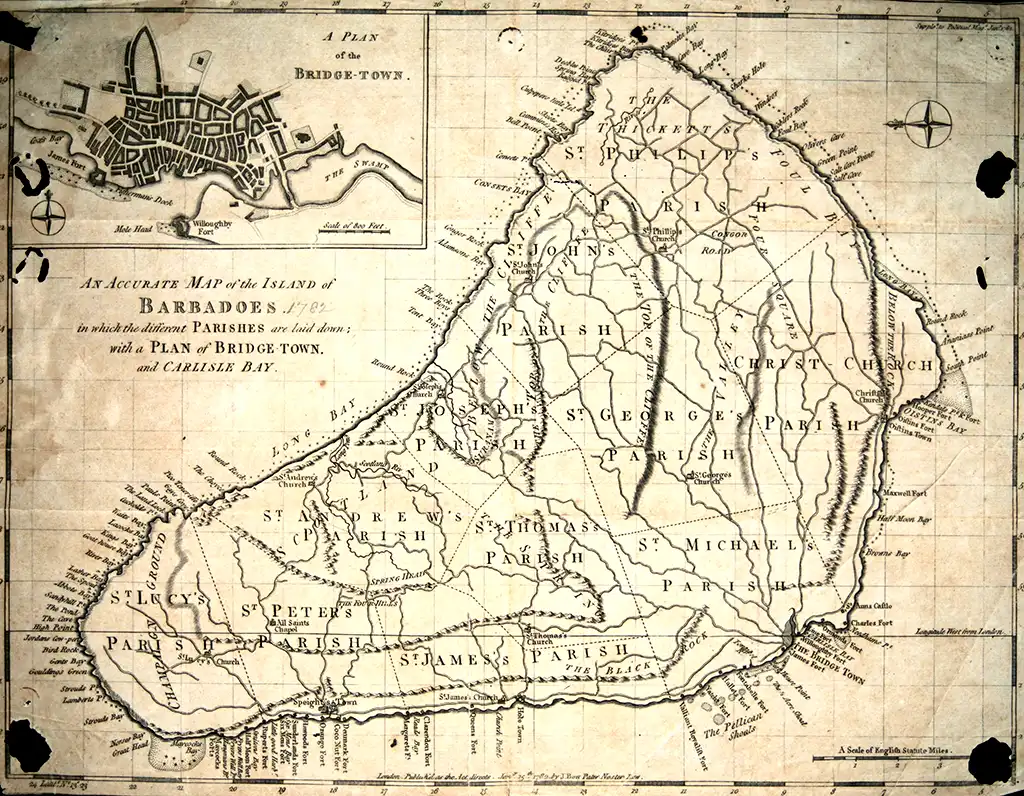
- 34 [1758] BELLIN (JACQUES-NICOLAS)
- 35 [1758 – 81] BELLIN (JACQUES-NICOLAS)
- 36 [1763] ROSSI (M. V.) – engraver
- 37 [1766] GIBSON (J.)
- 38 [1775] JEFFERYS (THOMAS)
- W [1777] MASI (GIOVANNI TOMMASO)
- W [1779] LE ROUGE (GEORGES_LOUIS)
- 39 [1780] LÓPEZ, (D. JUAN)
- 40 [1780] BONNE (RIGOBERT)
- S32 [1782] WALKER (THOMAS)
- 42 [1782] BALDWIN (R.)
- 43 [1782] LODGE (J) – engraver
- W [1782] NICHOLAS – French Maps of Barbados
- W [1786] LUFFMAN (JOHN)
- 41 [1788] BONNE (RIGOBERT)
- W [1793] LEACH (ELY)
- 44 [1794] EDWARDS (BRYAN)
Reference # (Numbers):
Map images from Campbell’s original book have a Plate # and reference No. #. Additional maps, which Campbell described and for which we’ve now added an image have a reference No. # only. The reference # correlates to the map description which are listed chronologically.
Maps referenced by Shilstone, in 1938, but not included in Campbell’s book have been added with a reference # beginning with “S”. eg. S20 would have been the 20th map on Shilstone’s list.
Moss intended that his work: “Further Notes on The Printed Maps of Barbados“, written 30 years after Campbell’s, should be read in conjunction with: “The Printed Maps of Barbados“. Alan Moss’ notes have been included in an indented quote block.
Maps without a plate or reference # have been added and inserted chronologically by Jim Webster in 2020 and denoted with a W.
Coloured Maps:
Prior to the 19th century maps were printed in black and white. In some instances hand colouring was added, after the printing, to enhance readability and appearance. If colouring was done, soon after printing, it was called original or contemporary colour. Colours added later were referred to as modern colour.
Laws of Carto-bibliography:
- Each printed map is an impression made by the transfer of ink from a unique printing platform or group of platforms (usually woodblock, copper plate or lithographic stone).
- The piece of paper we are looking at is no more than a reflection, literally a mirror-image, of a wooden, metal or stone printing platform, which was present in a particular workshop at a particular time.
The carto-bibliographer’s primary task is to recount the life history of a printing platform – the intentional and accidental changes made to it – by attempting to place in order a series of impressions pulled from it.
Tony Campbell “Understanding Engraved Maps“
Our thanks to Tony Campbell for supporting this transcription effort and for giving permission to re-publish “The Printed Maps of Barbados” which forms the basis for this project. You can follow Tony Campbell on Twitter: @portolanchart01.
Tony Campbell is an independent researcher who, for many years has been studying portolan charts. From 1987-2001 he was the Map Librarian at The British Library and is the chair of Imago Mundi Ltd, which has responsibility for Imago Mundi: The International Journal for the History of Cartography and for the coordination of International Conferences on the History of Cartography. We were able to contact Tony in 2018 to learn more about his work and the Barbados map project. He says:
…working up the carto-bibliography of Barbados was my very first foray into map history, done just a few months after I joined the firm of Francis Edwards Ltd, working with R.V. Tooley (author of Maps and Map-makers). The possibilities became immediately apparent when I pulled out the scores of maps of Barbados in the West Indies folder. That enabled me to sort out the different map ‘plates’, and the ‘states’, i.e. altered forms of each, especially of the small Moll maps. If you want to delve into that a bit you might find my article, “Understanding engraved maps“, a useful reference.
Tony Campbell
15 [1700] BROWNE (CHRISTOPHER)
[Barbados] 8 maps and insets on a sheet entitled: A New Map of the English Empire in the Ocean of America or West Indies. Sold by Chr. Browne at the Globe near the West end of St. Pauls Church, London. 60½ x 50½ cms.
Inset: St. Michaels or the Bridge Town.
This is a re-engraved and modified version of the 1696 Lea. Barbados, within an irregular frame with Bermudos, has been reduced and moved to the top left. A map of Tobago has been added and the map of St. Kitts transferred to the right hand side.
Another edition: Revised by J. Senex, 1721.
In: Senex (J.) A New General Atlas, London 1721. For illustration see Map Collectors’ Circle No. 19 (Maps of Bermuda) Plate XII.
The pagination in Senex’s A new, general atlas is irregular, with an initial sequence of 272 pages being followed by a sequence paginated 141- 270. The Barbados map is to be found between pages 244 and 245 in the second sequence.
A. Moss

WorthPoint® Corporation
16 [1700] LEA (PHILLIP)
Barbadoes. 17 x 21 cms. Inset: St. Michael or the Bridg Town.
In: Hydrographia universalis; or The sea coasts of the known parts of the world, sold by Philip Lea at the Atlas & Hercules in. Cheap-side London [1700].
The plate for Lea’s The Principal Islands in America belonging to the British Empire, described at 14 above, was apparently cut up to provide maps of the individual islands, for the Barbados map in Hydrographia Universalis is recognizably from the same plate as 14.
A. Moss

Barry Lawrence Ruderman

Barry Lawrence Ruderman
17 [1700] WELLS (EDWARD)
A New Map of the most considerable Plantations of the English in America. Sutton Nicholls sculp. 48 x 35½ cms.
Insets: Five, including 1 of Barbados, 8 x 8 cms. in bottom left corner.
In: A new sett of Maps both of Antient and Present Geography. Oxford 1700.
Other editions:
Oxford, Printed at the Theater, 1701.
London, Printed for A. and J. Churchill, 1706.
London, for R. Bonwicke, .l. Walthoe (&c) 1722.
London, Printed W. Bowyer for R. and J. Bonwicke, J. Walthoe, R. Wilkin and T. Ward, 1726.
London, J. & S. Bonwicke [1738].

Norman B. Leventhal Map & Education Center – Boston Public Library
S15 [1702] LABAT (JEAN BAPTISTE)
Plan de la Barbade. Illustrissimo viro Domino D…Marchiont de Nesmon Regiarum Classium Legato General Ozdinis St Ludovica Commendator oflerebat..Teruns Loannes, etc. Scale of one inch to a league. 18 x 16 ins.
Showing forts, batteries, etc. Original drawing on vellum very faded. Intelligence for this map had been collected by Labat, a French priest who had visited Barbados around 1700..
In: a Collection of Maps, Prints, Drawings, etc. forming the Geographical and Topographical collection attached to the Library of King George III and presented by King George IV to the British Museum.

British Library
W [1708] COVENS and MORTIER
America Septentrionalis in Suas Praecipuas Partes Divisa, ad usum Serenissumu Burgundiae Ducis 48.2 x 59.6 cms.
An extraordinary map, this is Covens and Mortier’s 1708 reissue of De L’Isle’s landmark 1700 mapping of North America. Covers the continent of North America from the Baffin Bay southwards as far as the Spanish Main, westwards to Cape Mendocino, and eastwards to include the Azores and the Sargasso Sea. Cartographically this map is practically identical to De L’Isle’s map though the title cartouche has been moved to the upper left quadrant and the mile scales to the upper right with a new curtain motif frame. Tooley, in his Mapping of America considers this to be a foundational map and indeed it is one of the most influential maps to emerge from the De L’Isle workshop. Some consider this map to be one of the first to revert California to a peninsular state following the insular suppositions of the late 17th and early 18th centuries. However, this may be a misreading of the map. De L’Isle leaves the northern terminus of the Gulf of California open such that, though the form of California is suggestive of a peninsular state, should exploration prove the opposite, the cartographer was covered.
Just to the east of Barbados, in the Antilles, a curious apocryphal island appears with the label “I. de Fonseca selon Quelquefuns”. This island, which is here surrounded by dangerous rocks and reefs, appears in several maps of the region as early as Hondius’ Americae Novissima Descriptio where it is identified as Y. de S. B. This island was also identified by M. Rochette with the label Galissioniere’s Rock. Other ships, including the Rainbow, claim to have seen the island as late as 1822. De L’Isle was the first to give the map a definite name, Fonseca. Even so, with so few sightings of the island it disappeared from most maps issued in the 18th century. There is some speculation that discolored water occasionally discharged by the nearby Orinoco River led to various false sightings of land. The condition of this map is of special note as it is nothing short of spectacular. The impression is so intense it is reminiscent of Coronelli’s work and the overall state of preservation is remarkable.

Wikimedia
18 [1708] MOLL (HERMAN)

Printed on page 1 of volume 2 of The British Empire in America: Containing the History of the Discovery, Settlement, Progress and Present State of All the British Colonies on the Continent and Islands of America (2 volumes; London: Printed for J. Nicholson et al., 1708), illust. by Herman Moll by John Oldmixon, 1673-1742.
Although Campbell states the first issue of this map to be in Herman Moll’s Atlas geographus (1717), it had been issued previously in the first edition of John Oldmixon’s 2-volume work, The British Empire in America (1707), sometimes opposite the title-page of volume 2 and sometimes opposite its page 1. The significance of the lettering Vol. 2 Page 1 which Campbell records as being present on the Atlas geographus issue thus becomes apparent. From an examination of the lettering on other plates in the work it is possible to deduce that its intended position is opposite page 1, rather than opposite the title-page.
The map is also present in the 2nd edition, 1741, of Oldmixon’s work. In this issue, to the top right-hand corner there has been added: (12)
For a Dutch edition of Oldniixon, Het Britannische Ryk in Amerika (Amsterdam: By Rudolf en Gerard Wetstein, 1721) the map was re-engraved, with the place names rendered in Dutch wherever possible (Scotland = Schotland, Lowe Point = Lowe Punt, etc.). The map appears not to have been altered for a 1727 issue (Amsterdam: By Hendrik Bosch).
“An account of the plates, maps and tables in all five volumes of the Atlas geographus” which is to be found in some copies of the Atlas geographus indicates that in this work the map of Barbados was placed between pages 460 and 461 of volume 5.
The Carrington Bowles issues identified by Campbell are distinguished by their having the lettering 57, ruled off, in the top right-hand corner (cf. Plate VII in Campbell).
Phillips indicates that the map is also called for in Moll’s Forty-two new maps of Asia, Africa and America (London: J. Nicholson,1716). (see: Yale Library)
A. Moss

Internet Archive – University of Pennsylvania

Internet Archive – University of Pennsylvania
18 [1717] MOLL (HERMAN)
A New Map of the Island of Barbadoes, containing all ye Parishes, and Principal Plantations; together with ye Forts, Lines, Batteries, Roads, &c. 25½ x 18 cms.
In: Atlas Geographus: or, A Compleat System of Geography (Ancient and Modern) for America . . . In the Savoy: Printed by Eliz. Nutt for John Nicholson at the King’s Arms in Little Britain [London 1711-17]. (This issue has: Vol. 2, Page 1, in the top left hand corner.)
Another issue: With the page number deleted.
In: Bowle’s Atlas Minor: containing a new and curious set of Sixty-Five Maps, by Herman Moll . . . Printed and sold by the Proprietor Carington Bowles . . . St. Paul’s Church Yard, London [c. 1765].
Another issue: “Printed for Carington Bowles in London” added beneath the title.

Barry Lawrence Ruderman
Yale Library

The Map House
see also:
24 [1729] MOLL (HERMAN)
W [1744] MOLL (HERMAN).
19 [1719] CHATELAIN (H. A.)
Carte qui contient une description des iles & terres que les Anglois possedent dans l’Amerique Septentrionale, 52 X 40½ cms. [Amsterdam, 1719.]
Inset: Ile des Barbades, 7¼ x 5¼ cms.
In: Atlas Historique, 7 vols. Amsterdam, 1705 – 20.
The map on which the inset occurs is lettered Tome VI no. 26 pag. 100, and it is indeed to be found as map no. 26 at page 100 of Volume VI. It does not appear in the 2nd edition, 1720 -1739, of the Atlas historique
A. Moss

Martayan Lan
W [1719] PLAN DE LISLE DE LA BARBADE
Cartes marines: a la svbstitvtion dv Valdec proche Solevre en Svisse, MDCCXXVII
Bound together in 1727 as an atlas comprised of 115 numbered leaves.
French
Sheet 065, Map and nautical chart of Barbados; fortifications and number of cannons. Scale 1:41,400

Edward E. Ayer Digital Collection (Newberry Library)
The 1719 Plan de Lisle de la Barbade was printed in a French Maritime Atlas of 1727. The full altlas is held at the Newberry Library in Chicago. This 1719 French map shows all the Barbados forts with the number of cannons. The spies must have been at work! It looks like it was based on the Father Labat map from 1702 – shown below for ease of comparison.
British Library
20 [1720] VAN KEULEN (GERARD)
Nieuwe Land en Zeekaart Van Het Eyland Barbados Geleegen in West India Onder de Caribesse Eylanden. 59 X 51 cms.
Inset: Plan of S. Michael’s of the Bridg Town, and 4 silhouettes.
In: Van Keulen (G.) De Groote Nieuwe Vermeerderde Zee-Atlas [Amsterdam] 1720.
Other issues: [1740] [1783].

Barry Lawrence Ruderman

The Map House
S 20 [1721] REVISED BY SENEX (JOHN) & HARRIS (JOHN) (engraver)
A New Map of the English Empire in the Ocean of America or West Indies. Barbados. Scale of English Miles, 5 [ = 40mm.] Published in John Senex’s: A New General Atlas; containing a geographical and historical account of all the empires, kingdoms, and other dominions of the World… (London: Daniel Browne, 1721).
A New General Atlas containing a Geographical and Historical Account of the Empires, Kingdoms, and other Dominions of the World: …… The Maps, which are all engraven or revised by Mr. Senex, are laid down according to the Observations communicated to the English Royal Society ….. Printed for Daniel Browne without Temple Bar, Thomas Taylor over against Serieants Inn in Fleet St., John Darby in Bartholomew Close. John Senex in Salisbury Court, William Taylor in Pater Noster Row, Joseph Smith in Exeter Change, Andrew Johnston Engraver in Round Court, Wiliam Bray next the Fountain Tavern in the Strand, Edward Symon in Cornhill.) [London,] 1721. fol,
One sheet 20 x 24 ins., partly coloured, comprising the West India Islands showing Barbados, with plan of St. Michael’s of the Bridge Town inset. Dedicated by the Under-takers to Prince George Augustus of Brunswick-Lunenburgh, Duke of Cornwall.

McMaster University Digital Archive
21 [1722] MAYO (WILLIAM)
A New & Exact Map of the Island of Barbadoes in America According to an Actual & Accurate Survey Made in the Years 1717 to 1721 Approved by the Royal Society & Authorised By His Majesty‘s Royal Licence. Engraved by John Senex 1722. 4 sheets 110½ x 94 cms.
Inset: Plan of the Bridge Town. Also a Prospect of Codrington College, and a vignette of a surveyor in a typical Barbadian setting. Mayo’s was the second systematic, and first large-scale, survey of the Island and it was on this that the legal bounds of the parishes were fixed. Schomburgk writing in 1847 suggested that the outdated boundaries should be revised, but it was not until the Admiralty survey of 1873 that Mayo’s map ceased to be the standard representation of Barbados.
Another issue: [1750] the words, “Made in the Years 1717 to 1721 . . . engraved by John Senex 1722” omitted.
Another issue: [1794] Watermark: JW Whatman 1794
An “Explanation” interprets the symbols used on the map for plantations, churches, fortifications, etc., and gives the “contents” (i.e. acreage) of the various parishes. The inset plan of the Bridge Town is noteworthy in that for the first time the names of streets are given, via another Explanation.
A. Moss

British Library
The Huntington Library
John Carter Brown (JCB) Library
Biblioteca Digital Hispánica

Although undated by an unnamed cartographer, this French map is closely based upon William Mayo’s map of 1722 identifying many of the plantation sand geographical locations of that map. During the 18th century there were a series of conflicts between the English and French which could account for why many Barbados fortifications are highlighted and clearly marked on this map, more so that on the original Mayo map.
Bibliothèque nationale de France (National Library of France)
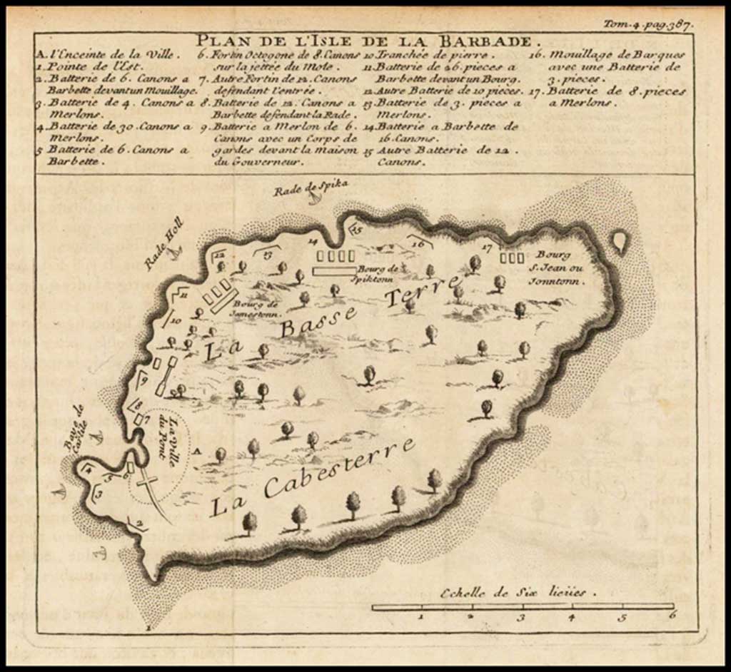
22 [1724] LABAT (JEAN BAPTISTE)
Plan de l’Isle de la Barbade. 13½ X 12½ cms.
In: Labat (J . B.) Nouveau Voyage aux Isles de l’Amerique. 2 vols. La Haye, 1724. (Lettered: Tom 1 pag 129.)
In: Labat (J. B.) Nouveau Voyage aux Isles de l’Amerique. 6 vols. La Haye 1724 (in Vol. 4).
In: Labat (J. B.) Nouveau Voyage aux Isles de l’Amerique. 8 vols. Paris, 1742. (Lettered Tom 6. pag 182.)
This extremely rare map, so inaccurate as to be almost unrecognisable, did not appear in the first edition of Labat 1722. Along the top of the map is a key to the places numbered in the sketch. Only the towns and fortifications are shown.
The map is based on a manuscript map housed at K.l23.116 in the King’s Library collection at the British Library, which is described in the printed catalogue of the collection as Plan desiné de la Barbade, 1702 and on the map itself as Plan de la Barbade, 1702. [See Figure 1.]
An extensive key at bottom left interprets the principal features identified on the map, i.e. the boundary of “La Ville”, lettered A on the map, and 20 locations relating primarily to fortifications and their armaments, numbered 1-20 on the map. The scale is given as “Eschelle de cinq lieues”.
A cartouche at top left bears an inscription in Latin, the bottom half of which is partially illegible because of damage to the map, and it is from this inscription that the British Library is able to state in a catalogue entry that the map is “dedicate-d to Andre’, Marquis de Nesmond, Admiral, by Jean…thor…Platevet de Paar”.
The printed versions (for there are two) differ chiefly in that the key is presented in a compartment above the map, and in that some of the features identified via the key in the manuscript version are now named on the map itself. Bridgetown, for instance, is now identified on the map (as “La Ville du Pont”), as is the Speightstown Roadstead (“Rade de Spika”) with the result that the key now interprets only A and nos. 1 – 17, rather than 1 – 20, while some features not to be found on the manuscript version (eg. La Basset Terre, La Cabesterre, and the names of three further towns) have been added to the body of the map. The scale of the printed versions is given as “Echelle de six lieues”’.
The most obvious distinguishing feature of the two printed versions is that in the earlier [see Figure II] the key is presented in four columns, while in the later it is in three columns, divided by ruled lines. Additionally, the names of features off the west coast of the island are presented at an angle in the earlier version. while in the later they are horizontal.
As is apparent from the following paragraphs, the 4-column version is used in Paris editions of Labat’s Voyage aux Isles de l’Amerique, while Dutch versions employ the 3-column version.
Although Campbell states that the 1st edition of Labatis Voyage aux Iles de L’Amerique (Paris: Chez Francois Giffart, 1722, 6 vols.) does not contain the map, it does appear in at least some copies, in the four-column version, lettered at top right Tom.4 bag 387.
The three-column version first appears in the 2-volume and 6-volume editions of Labat’s work published La Haye: Chez P. Husson (et al.), 1724. As Campbell notes, this issue is lettered Tomi pag. 129. An examination of the text, however, shows that its logical place in the 2-volume edition is at page 129 of volume 2, and in some copies it has been bound in at this point.
The three-column version reappears in an issue not recorded in Campbell, a 4-volume Dutch edition of Labat, Nieuwe Reizen naar de Franse Eilanden van America… (Te Amsterdam : By Balthasar Lakeman, 1725). This issue is lettered, at top right : III Deel. Pag.4. It should be noted, however, that volume 3 consists of two separately paged parts, and it is in the second pagination sequence that the map is to be found.
The 8-volume 1742 Paris edition of the Voyage appears to have been issued under at least four different imprints. That published Chez J .B. Delespine carries the 4—column version, lettered Tom.6.pag.182.
A. Moss
Barry Lawrence Ruderman
Biliotheque National de France
23 [1728] BERMUDAS AND BARBADOS (with Boston Harbour and Antego)
In: [Cutler (Nathaniel)] Atlas Maritimus et Commercialis…. by Senex. A General View of the World so far as relates to Trade and Navigation. 1728. 26½ x 48 cms.
Bermuda and Barbados occupy the right-hand page of a double-page spread produced from a single plate appearing in Nathaniel Cutler’s A general coasting pilot containing directions for sailing into and out of the principal ports and harbours throughout the known world… (London : Printed for James and John Knapton [et al.], 1728), which forms the second part of the Atlas maritimus & commercialis; or, A general view of the world so for as relates to trade and navigation… to which are added sailing directions for all the known coasts and islands on the globe (London : Printed for James and John Knapton [et al.], 1728). The page is divided into two compartments separated by an irregular rule, with Bermuda in the upper and Barbados in the lower. Untitled on the pages themselves, in “A list of the Charts &c. belonging to the General Coasting-Pilot. annex’d to the Atlas Maritimus” the map is listed at no. 48 as “A Draught of the Islands of Antegoa, Barbadoes and Bermudas; together with Boston Harbour.” Although the Atlas and the Coasting pilot each has its own title-page and is separately paginated, the wording for of the “List of Charts” and of the Atlas’s title-page suggest that they were issued as a single entity.
The map is lettered 48, at bottom right.
The John Carter Brown Library ascribes probable authorship of the Atlas maritimes & commercials to John Senex, whose name is included amongst those for whom the work was printed.
A. Moss

Barry Lawrence Ruderman
24 [1729] MOLL (HERMAN)
The Island of Barbadoes. Divided into its Parishes, with the Roads, Paths, &c. According to an Actual and Accurate Survey. By H. Moll, Geographer, 1728. 36½ X 29 cms.
Imprint: Sold by H. Moll, over against Devereux court, between Temple-Bar and St. Clement’s Church in ye Strand; where may be had His Set of thirty-two new Maps of ye Principal Parts of Europe, with roads.
Beneath “Note, This Pocket Companion . . .” (top right of the map) is a note, “Very usefull for all Gentlemen that Travel to any part of Barbadoes”.
In: Atlas Minor; or, a set of Sixty-two New & Correct maps, 1729.
Another issue: Date, imprint and note “Very usefull for all Gentlemen that travel . . .”, erased, though clear traces of them remain. In place of the imprint is a new note about the geography of the Island and another, within a triangular frame, on the history. Outside the frame, top left is, V.3, p. 587, and top right, 59. Within the frame, bottom right is the new imprint: “Printed and Sold by Tho: Bowles next ye Chapter House in St. Paul‘s Churchyard & I. Bowles & Son, at ye Black Horse, Cornhil (sic)”,
In: Atlas Minor. Printed for Thomas Bowles & John Bowles [1732] (the maps are dated to 1732.)
Another issue: top left reads Vol. 3, p. 638. Last line of the imprint now reads: “1. Bowles at the Black Horse in Cornhill.”
Another issue: Volume and page numbers erased.
In: Atlas Minor. London Printed for Thos. Bowles in St. Pauls Church Yard & John Bowles at the Black Horse in Cornhill [1745].
Another Edition: 34½ X 28 cms. [1739].
No imprint. Entirely re-engraved but a direct copy of the first edition with the following differences:— Outside the frame, top right, is the number 64, and bottom right, the letters QQQ. As this was copied from the first issue the note: “Very usefull for all Gentlemen . . .” re-occurs and the note within the triangular frame is omitted, but in place of the original imprint is a note about the position of Bridgetown. There are also traces of the original date, 1728, which can only be accounted for by supposing that the engraver copied the plate so zealously as to include a date which would have made the map 11 years out of date at the moment of publication, and which had therefore to be erased.
In: Modern History: or, the Present State of all Nations, 6 vols. Printed by and for George Grierson . . . at the King’s Arms and Two Bibles in Essex Street [Dublin], 1739.
Another issue: Printed and Sold by Geo: Grierson at the Two Bibles in Essex Street, Dublin. With the additions of the note within the triangular frame, and the geographical note which follows beneath, “The longetude of The Bridge Town . . .”
In: Just Publish’d Atlas Minor: a set of Sixty-Eight New and Correct Maps . . . The Third Edition with the Addition of Six Maps . . . Dublin: Printed by George Grierson. [1745]
The maps are dated up to 1732 but the title page cites the work which contains the first Grierson issue, “Modern History” (1739). The claim to be the Third Edition was presumably to disguise the fact that this was a pirated edition.
N.B.—The dating of the various issues of the Atlas Minor can only be tentative as, in the later issues, neither the title nor maps were dated and the book was often re-issued with the engraved title unchanged.
The 1717 Moll is based on Ford’s map and follows that in being oriented with the west at the top. The 1729 Moll is an entirely new map with the orientation reversed and the parish boundaries shown according to Mayo’s survey. However as Carington Bowles (the publisher of later issues of the 1717 Moll) was born in 1724 and appears to have been active in the period 1764 to 1793 the original Moll must have been re-issued at a much later date, despite the existance of a more modern version.

David Rumsey Map Collection (1732 ed.)

The Map House
See also:
18 [1708] MOLL (HERMAN)
18 [1717] MOLL (HERMAN)
W [1744] MOLL (HERMAN).
25 [1733] POPPLE (HENRY)
The Island of Barbadoes. London 7½ x 9½ cms.
Engrav’d by William Henry Toms 1733.
Insert (with three others): on Sheet 20 and last of Popple’s “A Map of the British Empire in America”
Popple’s A map of the British Empire (London : Stephen Austen, [1733]) now also exists in reprint (Lympne Castle, Kent : Harry Margary, 1972).
Sabin gives an original publication date of [1732], with re-issues in 1733 and 1740.
A. Moss

David Rumsey Map Collection
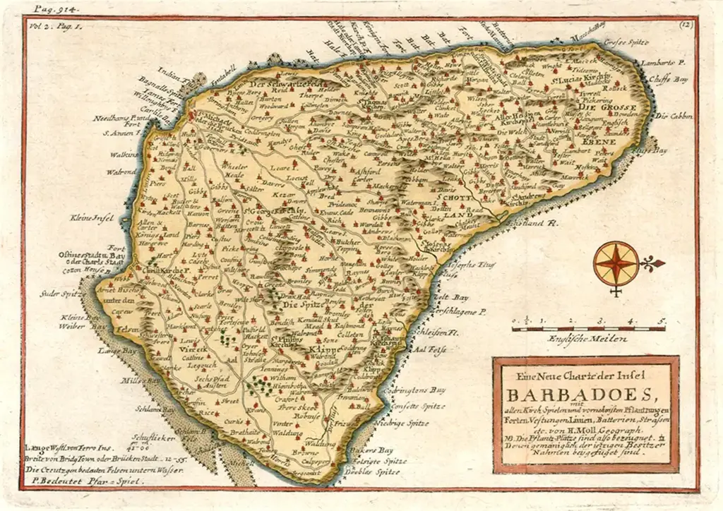
26 [1737] HOMANN (J. B., heirs)
Insula Barbadoes in Suas Parochias distincta, una cum Oris maritimis, Viis &c. Ad fidem Anglicani Authoris delineata. 28 x 22 cms.
One of 5 maps on a sheet titled: Die Englische Colonie-Laender auf den Inseln von America: Dominia Anglorum in Praecipuis Insulis Americae 55½ x 48½ cms.
In: Grosser Atlas . . . Nurnberg . . . Homannischen erben 1737. Also 1747.
In: Schul Atlas, 1743.
In: Atlas Novus sive Tab. Geographicae . . . Tobias Conrado Lotter Augustae Vindelicorum [1752].
The Barbados map is copied from the 1729 Moll with the explanatory text in German and Latin.
Phillips indicates that the map is also called for at map 142 in the Homann heirs’ Atlas geographus maior (Norimbergae : curantibus Hommanianis Heredibus, 1759-[1784].
A. Moss

Library of Congress (zoomable map)


Yale Library

George A. Smathers Libraries, University of Florida (zoomable map)
27 [1740] [DELISLE (GUILLAUME)]
The Island of Barbadoes. 7 X 9 cms.
On sheet: Les Principales Forteresses Ports &c. de l’Amerique Septentrionale. 60 x 48 cms. [Covens & Mortier, Amsterdam]
Delisle gathered together all the insets from Popple’s map and published them on one sheet. This is a crop from the full sheet.

New York Public Library
Another issue: COVENS & MORTIER 1745 circa Hand Coloured 24 x 19.5 inches
Les Principales Forteresses Ports &c. De L’Amerique Septentrionale (Harbors, Towns & Fortreses of North America, including Charleston, New York, Curacao, Bermuda, Boston, Placentia, Fort Royal, Anapolis Royal, Providence, Barbados, Antigua, Cartagene, Kingston, Porto Bello, San Antoino

Barry Lawrence Ruderman
Norman B. Leventhal Map Centre
W [1740] BUACHE (PHILLIPPE)
Port, baye cul de sac Royal dans la Martinique — Isle des Barbades une des Isles Antilles — Cartagene située sur le Côte de la nouvelle Espagne dans l’Amerique septle. — Port de Porto Belo à la Côte Septle. de l’Isthme de Panama.
4 maps on 1 sheet. Hand Coloured. 53 x 35 cm. French (outside lower right border) a Paris, ave Privilege du Roy, (inside lower right border) Desbrustins Sculp.
Notes: Plate 6 of Plans des isles, rades, et ports de plusieurs lieux de l’Amérique tirés de la carte angloise de Mr. Popple publiée en 1733 à Londres en vingt feuilles. Relief shown pictorially. Depths shown by soundings.
Citation: Tooley, R. V. Mapping of America, p. 30-31, plate 19.

Norman B. Leventhal Map & Education Center
W [1744] MOLL (HERMAN)

Internet Archive – John Carter Brown Library
Herman Moll 1744 Island of Barbadoes published in German based on a translation of John Oldmixon’s 1741 edition of: “The British Empire in America, containing the history of the discovery, settlement, progress and present state of all the British colonies on the continent and islands of America” (Das Britische Reich In America: Worinnen Enthalten Die Geschichte Der Entdeckung, Der Aufrichtung, Des Anwachses Und Zustandes Der Englischen Colonien … In Sich Begreifft Eine…)
The British Empire in America
The Second Part
With land charts from the famous Hn. Molls provided and according to the latest edition from 1741, translated from English to German by Theodor Arnold.
Published by Lemgo : Bey Johann Heinrich Meyer, Hochgräfl. Lippis. Hof-Buchdrucker.
The map includes many towns, plantations, roads, rivers,churches, bays, inlets, etc
See also:
18 [1708] MOLL (HERMAN)
18 [1717] MOLL (HERMAN)
24 [1729] MOLL (HERMAN).

Internet Archive – John Carter Brown Library
Barry Lawrence Rowerman
28 [1746] TRAIL (JOHN)
A Map of the fortified part of the Island of Barbadoes drawn by John Trail, Engineer, Feb. 9, 1746, with a list of the forts and batteries in the Island. Bridgetown, 1746. Ms. 2 inches to 1 mile.
Note: many English words were shortened during this period. y was short for the.
This is a manuscript map (hand drawn) with only one known copy. Held in the National Archives at Kew, it has yet to be digitized on-line (2022). Copies may be ordered via the link below the map.
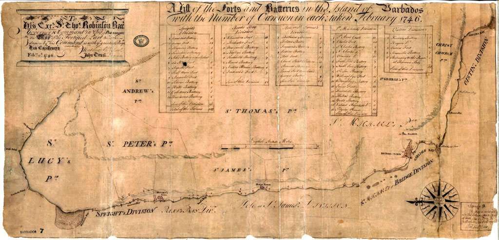
National Archives, Kew, UK
Click here to see a high resolution image


Translation: To his Excellency Sir Thomas Robinson Baronet Governor & Command in Chief of Barbados. This Map of the Fortified Part therefrom drawn by his command is with the greatest respect his Excellency’s February 9th, 1746. Inscribed by Most devoted humble servant John Trail Engineer.
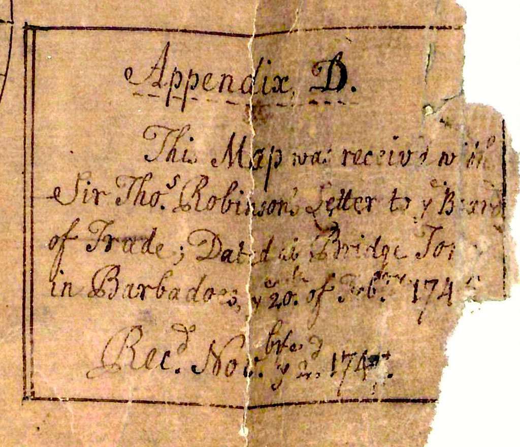
Translation: Appendix D. This Map was received with Sir Thos. Robinson’s Letter to the Board of Trade; Dated in Bridge Town in Barbadoes, on 20th of February 1746.


Detail of the Divisions
29 [1747] BOWEN (EMANUEL)
An Accurate Map of the Island of Barbadoes Drawn from an Actual Survey containing all the Towns, Churches, Fortifications, Roads, Paths, Plantations, &c. 42½ x 35 cms.
In: Bowen (E.) A Complete System of Geography, 2 vols, Herman Moll, 1747.
In: Bowen (E.) A Complete Atlas or District view of the known World, London, 1752.
Two issues have been encountered. One, with 69 at bottom left, outside of the border, has been found in copies of both Bowen’s A complete system of geography (1747) and his A complete atlas. The second, with 72 outside the border at bottom right, has so far been encountered only in the 1747 edition of A complete system of geography.
It has not yet been possible to examine a copy of an earlier edition of Bowen’s A complete system of geography (London : Printed for William Innys [etc.,], 1744) to determine whether it contains the Barbados map, and if so, which issue.
A. Moss

David Rumsey Map Collection

Library of Congress
Yale Library
30 [1748] LE ROUGE (GEORGES-LOUIS)
La Barbade une des antilles aux anglois divisee par Paroisse. A Paris. Par le Sr. le Rouge rue des grands Augustins. 20 x 27 cms.
With Isle St. Christophle (sic) on same sheet.
In: Atlas nouveau portatif… a I’usage des militaires et du voyageur, Le Rouge, Paris [1748] and 1756.
Another issue: A Paris. Chez Crepy 1767. Crepy acquired the c.1748 plates from Le Rouge’ s “Atlas Nouveau Portatif” and re-issued them in Paris, often adding his imprint and the date 1767.
All examples so far seen have the lettering 88 rotated through 90° outside the border at top left, the map having been issued as a double-page spread with north to the right and 88 being the page number or plate number.
A. Moss

The Map House
Barry Lawrence Ruderman

University of Florida – Digital Library of the Caribbean
Library of Congress

Old Print Shop
W [1748] ADMIRALTY PLANS (unknown engineer) – WILLOUGHBY FORT and JAMES FORT
Two plans of Bridgetown defences:
- Willoughby Fort, with the adjoining Fascine Battery in Carlisle Bay
- James Fort in Carlisle Bay
Dimensions: 35.5 cm x 51.5 cm
Held at The National Archives, Kew, Catalogue reference: MPH 1/307/4
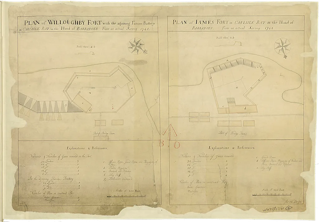
Source: UK National Archives – can be ordered online.
Click here to see a high resolution image
The Board of Trade and Plantations was created, in 1696, out of a committee of the Privy Council as the main British colonial office to oversee colonial affairs. Since its inception there was regular correspondence between the board and the colonies, in particular the colonial governors.
In the period around the late 1740’s there was often updates, from Barbados Governors Robinson and Sir Henry Grenville on the island defences and a possible French settlement being established in Tobago.
The Barbados Assembly had requested that Governor Robinson be replaced due to the money he was spending on defences for his residence at Pilgrim, now the site of Government House.
His replacement Sir Henry Grenville sent an updated report on the island’s forts, batteries, ammunitions and cannons in late 1747.
In 1748 plans were drawn showing the defences along Carlisle Bay at Charles Fort, Fort Willoughby and Fort James. Although little of nothing remains of forts Willoughby and James, which were near the entrance to the careenage, Charles Fort looks relatively the same after 275 years.
W [1748] ADMIRALTY PLANS (unknown engineer) – CHARLES FORT
Plan of Charles Fort and the two adjacent Fascine Batteries at Needham’s Point in Carlisle Bay in the Island of Barbadoes from an actual survey A.D. 1748
Scale: 1 inch to 40 feet, 1:480
Size: 47.8 cm x 60.5 cm
Held at The National Archives, Kew, Catalogue reference: MPH 1/597/2
This map was prepared during the period when Henry Grenville was Governor. There was concern about France trying to settle the nearby island of Tobago. It was a period of colonization and successive wars with France.

Source: UK National Archives – can be ordered online.
Click here to see a high resolution image
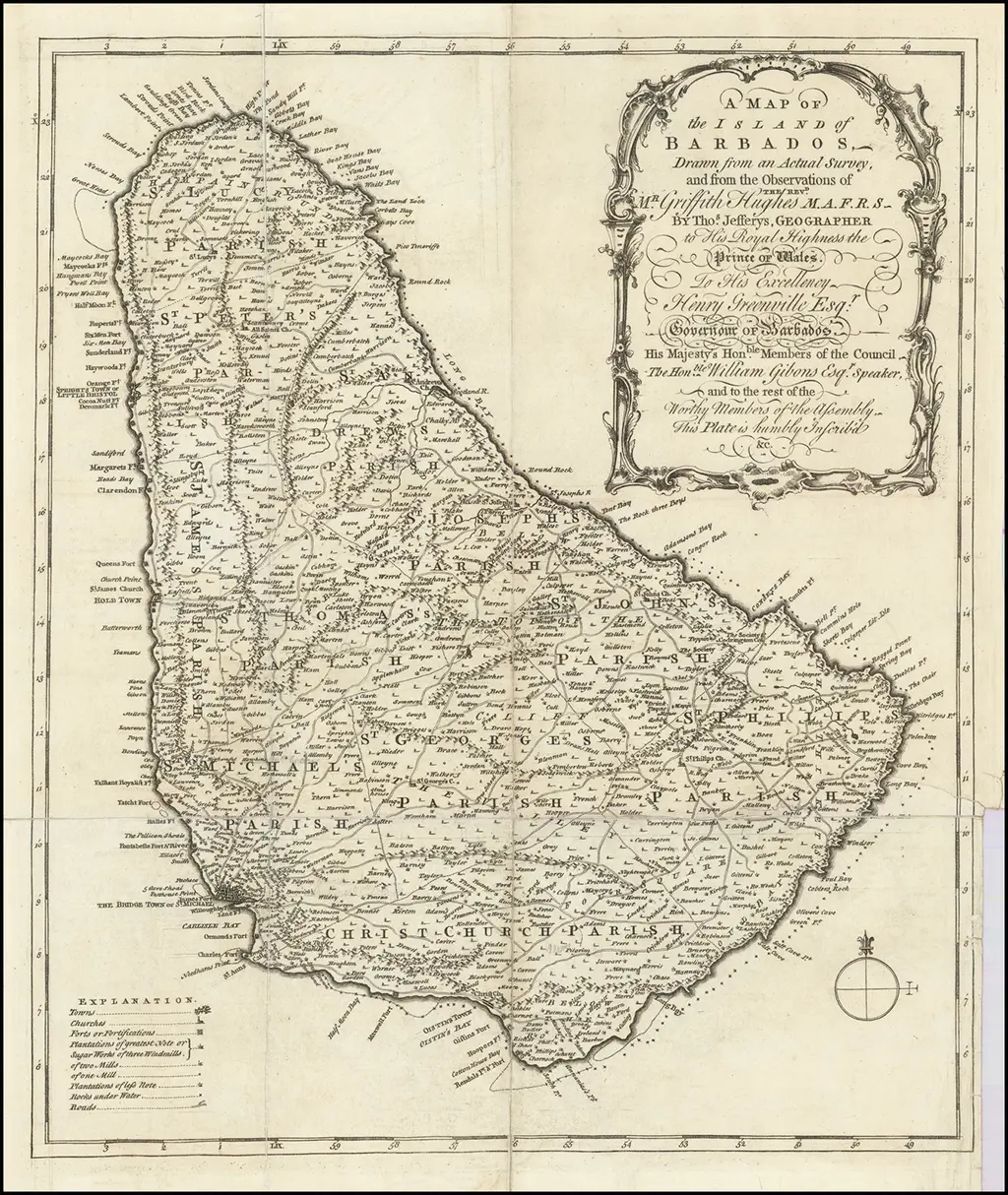
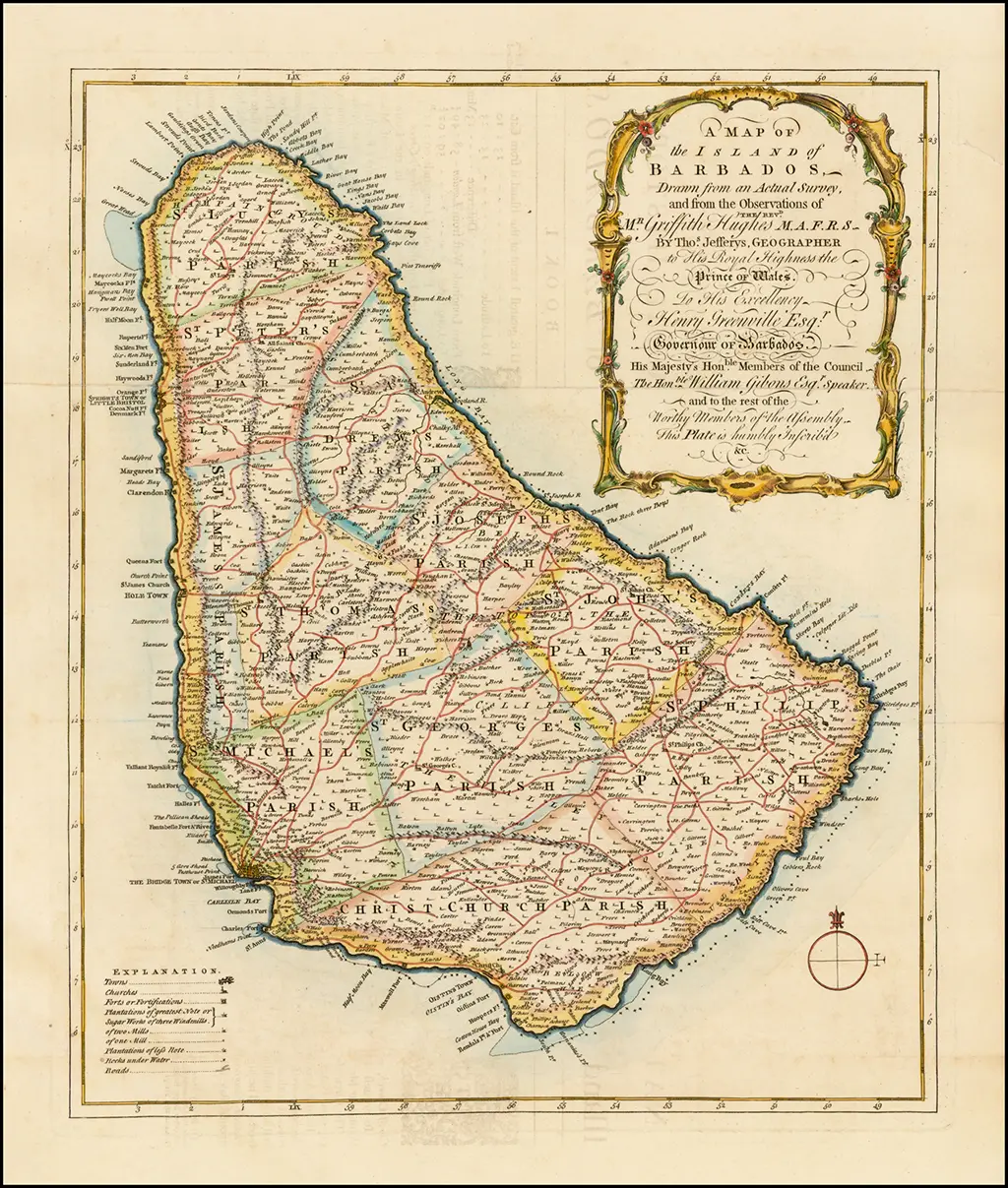
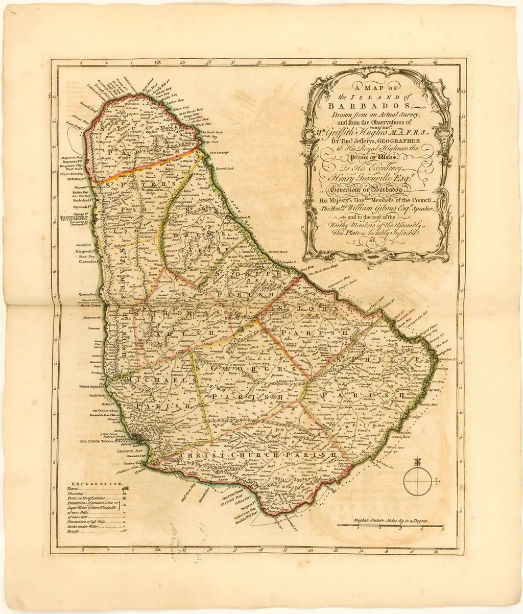
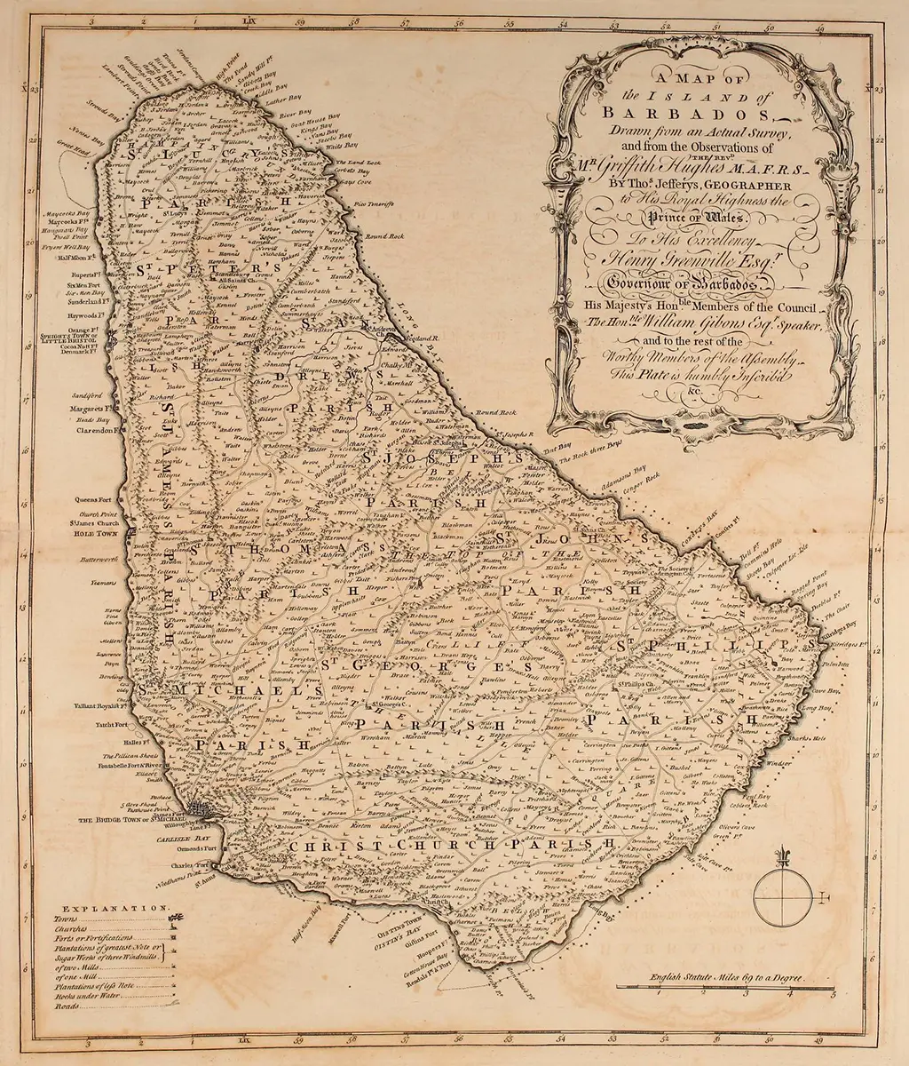
31 [1750] JEFFERYS (THOMAS) / HUGHES (GRIFFITHS)
A Map of the Island of Barbados, drawn from an Actual Survey, and from Observations of the Revd. Mr. Griffith Hughes, M.A.F.R.S. by Tho.s Jeffreys Geographer to His Royal Highness the Prince of Wales.
[London, 1750]. 35 ½ x 42 cms.
In: Hughes (G.) Natural History of Barbados, 1750
The Life and Work of Thomas Jefferys (ca.1710-1771)
As is implied in the “List of the Subscribers” present in all copies of Hughes’s The natural history of Barbados, a number of copies on “large paper” were produced.
Two issues of the map exist, differentiated by the presence or absence of a scale below the compass rose: English statute miles 69 to a Degree.
A. Moss
Barry Lawrence Ruderman Antique Maps Inc.
Barry Lawrence Ruderman Antique Maps Inc.
JCB (John Carter Brown) Library
The Natural History of Barbados : in ten books – Internet Archive

The Natural History of Barbados : in ten books – Internet Archive
32 [I756] MAYO (WILLIAM)
New and Accurate Map of the Island of Barbadoes, with some late improvements. R. Sayer, London, 1756. 47 ½ x 56 cms.
Insert: Plan of Bridge Town
The full title of the map is: A New & Accurate Map of the Island of Barbadoes, Divided into its Parishes, Containing all the Towns, Plantations, Forts, Capes, Bays, &c. Actually Surveyed by William Mayo. With some late Improvements. 1756
And the full imprint, centred outside the bottom border, reads: London: Printed for Robt. Sayer at the Golden Buck opposite Fetter Lane Fleet Street.
The inset “Particular Plan of Bridge Town” contains most but not all of the information given in the inset in the earlier, much larger representation of Mayo’s map (see 21, above), and the bulk of the information is presented on the plan itself rather than via an Explanation.Similarly, a less detailed Explanation is provided for the main map (with only two categories of plantation or sugar works identified, as opposed to four on the 1722 map). There is no table showing the acreage of the parishes, and not all of the names of either coastal or inland features have been transferred.
The map has twice been reprinted in recent years in Barbados.
A. Moss

sent to BajanThings by John Knox
33 [1758] BELLIN (JACQUES-NICOLAS)
Carte de I’Isle de la Barbade dressee au Depost des tee des Vaisseaux du Roy. 40 x 56 cms.
ln: Bellin (Jacques-Nicolas) Hydrographie francoise, 2 vols. and Neptune de l’Amerique Meridionale.
There are two issues of this; one lettered No. 81 on the top right with bottom left: “Pris, Trente sols,” and the other without the lettering.
The map is listed at 81 in the “Table des cartes” of the Hydrographie francoise.
There is another issue in which a small circular seal reading “Depot de la Marine” has been added, off the St James coast, with the price given as “Prix. dix huit Sols” (Price. 18 sols).
In another issue the price reads. Prix. tente sols (Price. 30 sols).
[A livre was was a unit of currency in France equal to one pound of silver. The sol, or sou, was equal to ¹⁄₂₀ of a livre and each sol was made up of 12 deniers. In 1795, the livre was replaced by the franc, and the sol became obsolete as an official currency division. However, the term “sou” continued to be used as slang for ¹⁄₂₀ of a franc.]
A. Moss

Norman B. Leventhal Map Center
David Rumsey Map Collection
34 [1758] BELLIN (JACQUES-NICOLAS)
Carte de l’lsle da la Barbade. 15 x 19½ cms.
In: Description Geoographique des lsles Antilles possédées par les anglois. Paris, Didot, 1758.
In: Bellin (Jacques-Nicolas) Petit Atlas Francois Recueil de cartes et plans des quatre parties du monde (Vol. l) 1763 – 4.
(in this first issue the map has no volume or page numbering)
Another issue: Lettered Tome 1. No. 98. in: Bellin: Petit Atlas Maritime (VOL. 1) 1764.
Another issue: “Pour servir a l’Histoire Générale des Voyages”, added beneath the title. Along the bottom Tom. XV in 40 No. 17 and Tome 15 in 80, page 567.
In: La Harpe (J.) Abrégé de I’Histoire générale des voyages, 1780.

Library of Congress

Library of Congress

Old World Auctions – Richmond, Virginia, USA.
35 [1758 – 81] BELLIN (JACQUES-NICOLAS)
Carta dell’lsola della Barbada. 15 x 19 ½ cms. [Venice, 1781.]
In: Teatro della guerra maritima, Venezia, 1781.
(The map completely re-engraved with the place names mostly in Italian.)
For further details on the Bellin map editions see Addendum by Alan Moss.


36 [1763] ROSSI (M. V.) – engraver
Carta esatta rappresentante l’Isola di Barbados. 18½ x 22½ cms. D. Verem. Rossi M. V.sc.
In: 11 Gazzettiere Americano . . . del Nuovo Mondo, 3 vols, Livorno, 1763.
In: Atlante dell’America, Livorno, 1777.
Based on and very similar in appearance to the small Bellin.

Antiquarius – Rome
37 [1766] GIBSON (J.)
A Plan of Bridge Town, in the Island of Barbadoes. J. Gibson del. et sculp. 19 x 11 cms.
Published in: The Gentleman’s Magazine and historical chronicle, September 1766, vol. 36, p. 425.
A note under the title block states: NB. The part unshaded was Destroyed by Fire May 14th 1766.
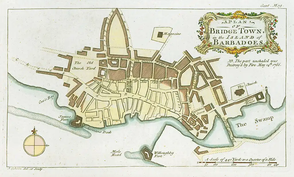
University of Texas Arlington
The University of Florida George A. Smathers Libraries
38 [1775] JEFFERYS (THOMAS)
Barbadoes, Surveyed By William Mayo, Engraved and Improved By Thomas Jefferys. Robert Sayer 20 Feb., 1775. 45½ x 61 cms.
In: The West-India Atlas, or, A Compendious Description of the West-Indies Illustrated With Forty Correct Charts And Maps Taken From Actual Surveys. Together With An Historical Account Of The Several Countries And Islands Which Compose That part Of The World. Their Discovery, Situation, Extent, Boundaries, Product, Trade, Inhabitants, Strength, Government, Religion, &c. By The Late Thomas Jefferys, Geographer to the King.
Published by Robert Sayer and John Bennett, London, 1775. (see: The Library of Congress)
Published by Robert Sayer and John Bennett, London, 1783. (see: David Rumsey Map Collection)
– Robert Sayer and John Bennett, 1780.
– Robert Sayer and John Bennett, 1783-7.
– R. Sayer, 1794.
In: Atlas des Indes Occidentales, Londres R. Sayer & J. Bennett; Paris, Julien, 1777.
– R. Laurie and J. Whittle, 1795.
Another edition: dated 1794.
In: West India Islands, R. Laurie & J. Whittle, 1795.
– Laurie & Whittle, [1797].
In: West India Atlas, Laurie & Whittle [1796].
– R. Laurie & J. Whittle, 1807. Another edition: Improved edition 12 March, 1810, Laurie & Whittle.
In: West India Islands, Robert Laurie & James Whittle, 1810.
In: West India Atlas, J. Whittle & R. H. Laurie, 1818.
Another edition: Improved edition 1st January, 1848, Richard Laurie, London (Published as a single map).

Old World Auctions
The Library of Congress

Barry Lawrence Ruderman
Barbadoes Surveyed By William Mayo, Engraved and Improved By Thomas Jefferys Geographer to the King
Published 12th of May 1794 by Laurie & Whittle Nº 53, Fleet Street, London
Scale 1:58,000, One Sea League of 20 in a Degree, Statue Miles 691/2 in a Degree
66 x 52 cm
This map was published many years after the death of Thomas Jefferys.

Biblioteca Digital Hispánica Biblioteca Nacional De España
W [1777] MASI (GIOVANNI TOMMASO)
Carta esatta rappresentante I’Isola di Barbados
21 x 16 cm, on a sheet 37 x 25 cm
Published in Livorno

Barry Lawrence Ruderman Antique Maps
The maps and text in this atlas were first published during the French and Indian War, in Il Gazzettiere Americano, published by M. Coltenllini in Livorno in 1763.
The text for that work was translated from the 1763 London American Gazeteer.
Giovanni Tommaso Masi republished this section of that work in 1777, as interest in the Americas increased during the American Revolution.
The map of the island of Barbados shows drainage, parish boundaries, forts, ports and major towns.

David Rumsey Map Collection Cartography Associates
Barry Lawrence Ruderman Antique Maps (image 28)
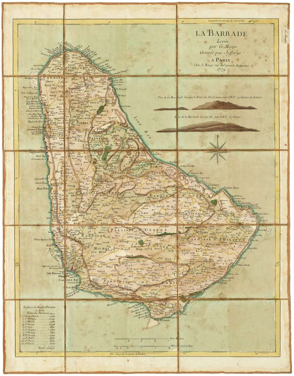
W [1779] LE ROUGE (GEORGES_LOUIS)
La Barbade. Based on the Jeffrey’s map of 1775 with different colouring, French text for Parishes and some other locations. All forts have been hi-lited in red. JW
levée par G. Mayo ; gravée par Jefferys. Contributors Mayo, William (Surveyor) Jefferys, Thomas 1771. Hand coloured. Scale 1:47,000. 46 x 59 cms.
Shows parishes, towns, bays, anchorages, topography and shoals Relief shown by hachures. Prime meridians: London and Ferro. Includes 2 views: Vue de la Barbade lorsque le Point du Nord vous reste O.N.O. a 9 lieues de distance — Vue de la Barbade lorsqu’elle gist O.N.O. a 7 lieues. Includes list of acreage of parishes. Manuscript label on verso: No. 57. Isle de la Barbade.
The French plate is clearly a different one (from the English Jeffrey’s map). Just compare any of the lettering. Even if the letters are the same the way it is written is not. You just need to be able to compare much enlarged sections, looking for the differences, not the inevitable similaritie. After all, one will always have been very closely copied from the other
But what is interesting is the way that instead of either translating it throughout or leaving it entirely as it was, he decided to go half way.
The parish names are translated and some other ones too (somewhat arbitrarily, e.g. Pointe meridionale at the extreme south but High Point left at the north. Grand Cap for Great Head, and so on. Chateau ste Anne. I dare say he, or his engraver, were translating some of the descriptive names, so we get Forts de Maycock, but Cuckholds Point (perhaps he didn’t know what it meant!).
Intriguingly, just above Bridgetown you get Basses d’un demi Acre for The 1/2 Acre shoal. But that is one of the quite small toponyms, which have otherwise been left.
Essentially, what you have is an unusual example of a slightly translated map.
Tony Campbell – February 2020
The Washington Library
39 [1780] LÓPEZ, (D. JUAN)
Carta de la Isla de la Barbada. 1:95,000. 49 x 34 cms.
In: Lopez (D. J.) Atlas, Madrid, 1780.

Library of Congress
Biblioteca Nacional de España
40 [1780] BONNE (RIGOBERT)
Rigobert Bonne (6 October 1727 – 2 September 1794) was a French cartographer, widely considered to be one of the most important cartographers of the late 18th century.
In 1773 Bonne succeeded Jacques-Nicolas Bellin as Royal Cartographer to France in the office of the Hydrographer at the Depôt de la Marine. Working in his official capacity, Bonne compiled some of the most detailed and accurate maps of the period. (Wikipedia)
Supplement pour les Isles Antilles extrait des cartes angloises. 21 X 32 cms.
I. de la Barbade (7 x 7 cms.) one of 9 small insets beneath a map of the Virgin Is.
In: Raynal (G. T.) Histoire Philosophique et Politique. Atlas de toutes les parties connues du globe terrestre, Geneva, 1780.
Also a Dutch edition.

Boston Public Library – Norman B. Leventhal Map & Education Centre
David Rumsey Map Collection
Geographicus Rare Antique Maps
S32 [1782] WALKER (THOMAS)
Plan of Fort George on Mount Charity Barbados. 45 x 57 cms.
This plan is most humbly presented to His Excellency Major General Cunninghame, Governor and Commander in Chief &c., of Barbadoes by His Most Obedient and Most humble Servant Thomas Walker, Lt. Col. Light Infantry. Scale 1:1,380
(Above the dedication is a crest, a broken tree, with wreath and motto – Tandem.) Governor Cunninghame arrived as Governor July 13. 1780. He was recalled, and left Barbados June 18, 1783
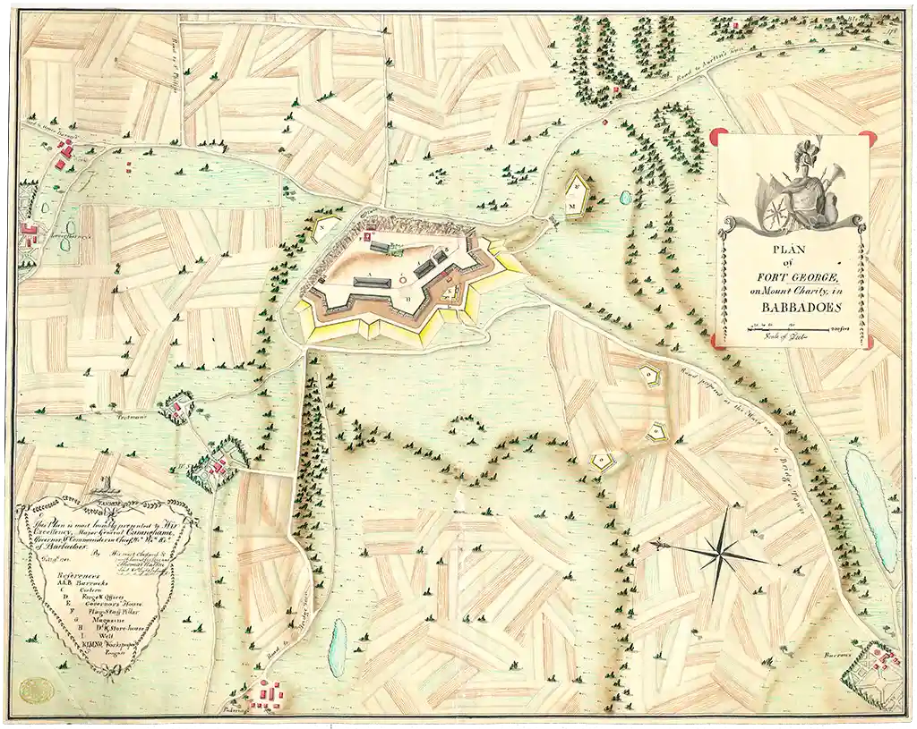
British Library Online Gallery
(unavailable after the British Library was hacked on 28th October 2023 by a ransomware attack)
Click here to see a high resolution image

Boston Public Library – Norman B. Leventhal Map & Education Center
42 [1782] BALDWIN (R.)
Island of Barbados. R. Baldwin. 10 x12½ cms.
In: London Magazine, April, 1782.
The Barbados map is one of four—with St. Lucia, St. Vincent and the Windward Is.—on a sheet, 19 X 24½ cms.

43 [1782] LODGE (J) – engraver
An Accurate Map of the Island of Barbadoes in which the different Parishes are laid down; with a Plan of Bridge-town and Carlisle Bay. J. Bew, London, Jany 15th, 1782. 37 x 28 ½ cms.
Inset: Plan of the Bridge-town. In: Supplement to Political Magazine, January, 1782. SEE
Click here to see a high resolution image

WorthPoint

WorthPoint
W [1782] NICHOLAS – French Maps of Barbados
Plan de la Baye de Carlisle de la Barbade. Echelle de 400 toises 1: 6 800 environ.
Translation: Map of the Carlisle Bay of Barbados. Scale of 400 fathoms 1: 6,800 approximately.

Bibliothèque National de France (BnF)
1782 NICHOLAS Carte de l’Isle de la Barbade suivant des Recherches. Exactes 1:60000.
Translation: Map of the Island of Barbados Following Accurate Searches. Scale 1:60,000.
Plan Detaillée De La Ville De Bridge-Town. Echelle de 50 Perches.
Translation: Bridgetown City Map. Scale 1:50 Perches (1 perch = 1 pole or rod and is equivalent to 5½ yards or 5.03m).

Bibliothèque National de France (BnF)
W [1786] LUFFMAN (JOHN)
A Map of Barbados E’graved by John Luffman
Publish’d Feby. 1st, 1786 by R. Wilkinson, No. 58, Cornhill , London
Hand coloured 48 x 41 cm.
This clearly engraved map shows the fortifications, churches, parish boundaries, main roads and towns plus rocks and reefs off-shore.

Harvard Library, Harvard University Map Collection
41 [1788] BONNE (RIGOBERT)
Cartes de Supplément pour les Isles Antilles. Andre’ sculp. 34½ x 23½ cms.
- de la Barbade (9 X 6½ cms.) one of 8 small insets (without Barboude) under the Virgin Is.
In: Encyclopédie Méthodique, Atlas, Paris, 1788.

W [1793] LEACH (ELY)
An accurate survey of the Estate called Seawells the property of Lady Sarah Holte and Mrs Elizth Newton situated in the Parish of Christ Church in the Island of Barbados’ and dated ‘June 5 1793.
Watercolour 43.1 x 55.8 cm. (17 x 22 in.)
This manuscript map of Seawells Plantation was drawn just after the deaths of the sisters Lady Sarah Holte and Mrs Elizabeth Newton by local Land Surveyor Ely Leach. It shows location and size of the plantations fields and the building along with a sketch of the houses and sugar works. It also shows the location of the bounding properties.

The British Library
With the sister’s deaths a survey would have been required to complete the land transfer. An advertisement in Barbados Mercury on the 26th July 1783 , by Ely Leach indicates that he had acquired a large collection of old plot maps, which he would have been able use as a reference when doing new surveys. The advertisement reads:
ELY LEACH, LAND SURVEYOR. Acquaints his friends and the public, that he has removed from the house he late lived in, to the one next door to the Secretary’s office, and opposite Doctor John Olton’s, where he shall think himself happy in having the commands of those ladies and gentlemen, who may please to confer their favours on him; will attend to any part of the island on the shortest notice, and will make it his chief study to do his business with accuracy and dispatch. The valuable collection of old plots he purchased and has been collecting for ten years past, he hopes will be a further inducement to the public for their patronage, as it will certainly be in his power to settles the bounds of lands from old records with great exactness
“After John Newton’s death in c. 1706 the estates were inherited by his son Samuel (died ?), and subsequently by Samuel’s son John (died 1783). On John Newton’s death the plantations came into the possession of his sisters, Sarah Holte and Elizabeth Newton. After the deaths of the two sisters the land passed, in 1794, to Elizabeth’s cousins, John Lane a barrister of King’s Bromley in Staffordshire and Thomas Lane who was a solicitor in private practice of Leyton Grange in Essex.” From the National Archives catalogue description of the Papers of the Newton Family, which includes a manuscript copy of this map. (Source: National Archives Newton Family Papers)
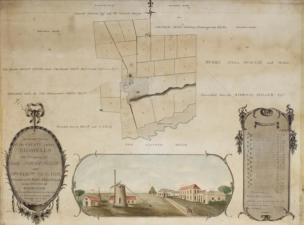
Bonham’s Auctions
44 [1794] EDWARDS (BRYAN)
Map of the Island of Barbadoes; for the History of the West Indies, by Bryan Edwards Esqr., G. Allen Sculp., John Stockdale, Piccadilly, Oct. 6, I794. 18½ x 23 cms. Ed. note: Campbell’sbook says 1794, map 1791
In: Edwards (B) The History, Civil and Commercial of the British Colonies in the West Indies, second edition, London, 1794. Also 1801, 1807.
Another edition: Tanner sc. In: A new atlas of the British West Indies … Engraved to accompany the Philadelphia edition of Edwards’ History of the West Indies, Charleston, 1810.
Another edition: In: Edwards ( B.) History of the British West Indies. 5 vols, 1818. (The imprints on the maps erased).

CaribMap
This is: The Printed Maps of Barbados – Part 2: 1700 – 1800. Click here to go to the previous or next section of The Printed Maps of Barbados 1500s – 1980s:


Leave a Reply