The Printed Maps of Barbados 1500s – 1980s is in 5 sections: 1500 – 1700, 1700 – 1800, 1800 – 1900, 1900 – 1980s & Addendums. This is: The Printed Maps of Barbados – Part 3: 1800 – 1900. The follow-on sections are:
- The Printed Maps of Barbados – Part 1: 1500s – 1700
- The Printed Maps of Barbados – Part 2: 1700 – 1800
- The Printed Maps of Barbados – Part 4: 1900 – 1980s
- The Printed Maps of Barbados – Part 5: Addendums
The Printed Maps of Barbados 1500s – 1980s, brings together the research of E. M. Shilstone, Tony Campbell, Alan Moss and Jim Webster.

- E. M. Shilstone published “A Descriptive List of Barbados Maps” in 1938 in the fifth issue of the Barbados Museum and Historical Society (BMHS) Journal. Eustace Maxwell Shilstone a Barbadian lawyer co-founded the Barbados Museum & Historical Society (BMHS).
- Tony Campbell authored “The Printed Maps of Barbados” in 1965, (Map Collectors’ Circle, No. 21). This was a key resource and inspiration for this project despite being out of print.
- Alan Moss contributed “Further Notes on The Printed Maps of Barbados” in BMHS Journal volumes XLI (1993) and XLV (1999).
With digital libraries now widely accessible, Jim Webster has expanded on their work, further enriching the collection of printed Barbados maps.
Sourcing Missing Maps, Additional Maps And Map Images
If you can help source images of any of the maps where there is no image or would like to suggest maps of Barbados that should have been included in “The Printed Maps of Barbados 1500s – 1980s” please contact me by either leaving a comment below or clicking on the BajanThings Contact Burts link and choosing from the Subject drop-down: “Barbados Maps – Forward to: Jim Webster”.
Jim Webster – 15th February 2020 (updated February 2025)
Old, historical and antique printed maps of Barbados: 1800 – 1900
The old, historical and antique printed maps of Barbados are listed chronologically. Maps referenced in Tony Campbell’s book start with a number. Maps referenced by Eustace Shilstone start with a “S”. Other interesting maps added by Jim Webster are denoted with a “W”.
- 45 [1814] THOMSON (JOHN)
- 46 [1816] LUFFMAN – no image available
- 47 [1818] BARRALIER (F. DE) – no image available
- 48 [1818] BARRALIER (F. DE) – no image available
- 49 [1818] BARRALIER (F. DE)
- 50 [1821] ADMIRALTY CHART
- 51 [1823] LUCAS (F.)
- 52 [1827] BARRALIER (F. DE)
- 53 [1828] NORIE (J. W.)
- 54 [1828 to 1857] ADMIRALTY CHART – no image available
- 55 [1835] SOCIETY FOR THE DIFFUSION 0F USEFUL KNOWLEDGE
- W [1837] HALLIDAY (SIR ANDREW)
- W [1845] MOODY (THOMAS) Lt. Col.
- 56 [1847] WALSH (BLAYNEY Wm.) – no image available
- 57 [1847] SCHOMBURGK (SIR ROBERT H.)
- 58 [1850] MAYOCK (l. D.) – no image available
- W [1851] WARD (W. C. ) Lt. Col.
- W [1853] PETERSON (AUGUSTS)
- 59 [1856] ADMIRALTY CHART 2485 WALKER (J. & C.) – engravers
- 60 [1859] TAYLOR (A.)
- W [1860] REICHEL (LEVIN T.)
- 61 [1870] WELLER (E.) – no image available
- 62 [1871] ADMIRALTY CHART – no image available
- 63 [1873] ADMIRALTY CHART
- 64 [1873] ADMIRALTY CHART
- W [1884] ADMIRALTY CHART – BARBADOS & BRIDGETOWN, HANSCHELL & Co.
- S52 [1887] ANCIAUX (GABRIEL) – no image available
- S53 [1890] HARRISON (J. B.) & JUKES-BROWNE ( A. J.)
- W [1895] LAURIE & Co. Ltd
- S54 [1895] GOAD (CHAS. F.) – Civil Engineer
- W [1877 to 1937] BARBADOS RAILWAY MAPS
Reference # (Numbers):
Map images from Campbell’s original book have a Plate # and reference No. #. Additional maps, which Campbell described and for which we’ve now added an image have a reference No. # only. The reference # correlates to the map description which are listed chronologically.
Maps referenced by Shilstone, in 1938, but not included in Campbell’s book have been added with a reference # beginning with “S”. eg. S20 would have been the 20th map on Shilstone’s list.
Moss intended that his work: “Further Notes on The Printed Maps of Barbados“, written 30 years after Campbell’s, should be read in conjunction with: “The Printed Maps of Barbados“. Alan Moss’ notes have been included in an indented quote block.
Maps without a plate or reference # have been added and inserted chronologically by Jim Webster in 2020 and denoted with a W.
Coloured Maps:
Prior to the 19th century maps were printed in black and white. In some instances hand colouring was added, after the printing, to enhance readability and appearance. If colouring was done, soon after printing, it was called original or contemporary colour. Colours added later were referred to as modern colour.
Laws of Carto-bibliography:
- Each printed map is an impression made by the transfer of ink from a unique printing platform or group of platforms (usually woodblock, copper plate or lithographic stone).
- The piece of paper we are looking at is no more than a reflection, literally a mirror-image, of a wooden, metal or stone printing platform, which was present in a particular workshop at a particular time.
The carto-bibliographer’s primary task is to recount the life history of a printing platform – the intentional and accidental changes made to it – by attempting to place in order a series of impressions pulled from it.
Tony Campbell “Understanding Engraved Maps“
Our thanks to Tony Campbell for supporting this transcription effort and for giving permission to re-publish “The Printed Maps of Barbados” which forms the basis for this project. You can follow Tony Campbell on Twitter: @portolanchart01.
Tony Campbell is an independent researcher who, for many years has been studying portolan charts. From 1987-2001 he was the Map Librarian at The British Library and is the chair of Imago Mundi Ltd, which has responsibility for Imago Mundi: The International Journal for the History of Cartography and for the coordination of International Conferences on the History of Cartography. We were able to contact Tony in 2018 to learn more about his work and the Barbados map project. He says:
…working up the carto-bibliography of Barbados was my very first foray into map history, done just a few months after I joined the firm of Francis Edwards Ltd, working with R.V. Tooley (author of Maps and Map-makers). The possibilities became immediately apparent when I pulled out the scores of maps of Barbados in the West Indies folder. That enabled me to sort out the different map ‘plates’, and the ‘states’, i.e. altered forms of each, especially of the small Moll maps. If you want to delve into that a bit you might find my article, “Understanding engraved maps“, a useful reference.
Tony Campbell
45 [1814] THOMSON (JOHN)
Barbadoes. 30½ X 50 cms.
On sheet: West India Islands (with St. Vincent).
ln: Thomson (1.) A New General Atlas, Edinburgh, London & Dublin, 1814, 1816. [1821], 1833.
The following variants of this map appear:——
- Drawn & Engraved for Thomson’s New General Atlas.
- Engraved by Kirkwood & Son, Edinburgh. Longitude W. from London, Longitude W. from Ferro.
- The same, with a thick shaded border behind the title.
- Longitude W. from London. etc. removed.

The Map House
46 [1816] LUFFMAN – no image available
Barbadoes.
In: Luffman’s Geographical and topographical atlas, London, 1816-15.
[No image sourced – please contact Jim Webster via the BajanThings Contact Burts link to assist]
47 [1818] BARRALIER (F. DE) – no image available
[Bridgetown and Carlisle Bay]. [London, 1818.] 34 X 37½ cms.
[No image sourced – please contact Jim Webster via the BajanThings Contact Burts link to assist]
48 [1818] BARRALIER (F. DE) – no image available
Carlisle Bay, Bridgetown, and suburbs, showing First Project of forming a grand naval establishment at Bridgetown. 34 X 37½ cms.
Printed from stone, Horse Guards [London]. 1818.
[No image sourced – please contact Jim Webster via the BajanThings Contact Burts link to assist]
49 [1818] BARRALIER (F. DE)
Carlisle Bay, Bridgetown, and its suburbs, showing the Second Project. 34 x 37½ cms. Printed from stone, Horse Guards [London]. 1818. Scale 1:12,350.
Second Project This intended project of joining a grand naval Establishment at Bridge Town is proposed with the view of making the island of Barbados the chief point of all naval and military operations in time of War, to afford safe ports to ships in case of distress, pursuit of an enemy; and to contain most of the Merchant Vessels, trading in the West Indian Seas, in the Hurricane months; by which means, the Commerce of Barbados must we presume, increase greatly, and would certainly make Bridge Town, the Mart of the West Indies; it would also be the means of creating a New Source of Trade with Spanish America if proper Encouragement were given to Merchants who would forward the Establishment such a beneficial Trade. by. Capt. F. de Barrallier. H.Q. 101st Regiment
The hurricane of October 1817 had caused considerable damage to the shipping in Bridge Town and Capt. Barralier drew up several plans with suggested ways of making the harbour both safer and able to accommodate more and larger ships.

The Huntington
50 [1821] ADMIRALTY CHART
A Survey of Carlisle Bay in the Island of Barbadoes from a MS. in the Hydrographical Office, by T. Payton, RN. Admiralty, March 26th, 1821. 47½ X 62 cms.
Inset: Silhouette of North and Pelican Island.

Old World Auctions (zoomable map)
51 [1823] LUCAS (F.)
Barbadoes. Drawn and published by F. Lucas jr., Baltimore. 23 x 29 cms.
In: A general atlas containing distinct maps of all the known countries in the world. Baltimore [1823].
In: A new general atlas of the West India Islands, Baltimore [1824].

David Rumsey Historical Map Collection
CaribMap
52 [1827] BARRALIER (F. DE)
[Trigonometrical Survey of Barbados] Engraved by J. & C. Walker, London, 1st June, 1825. Published by Capt. Barralier, June. 1827. 6 sheets, 115 x146 cms.
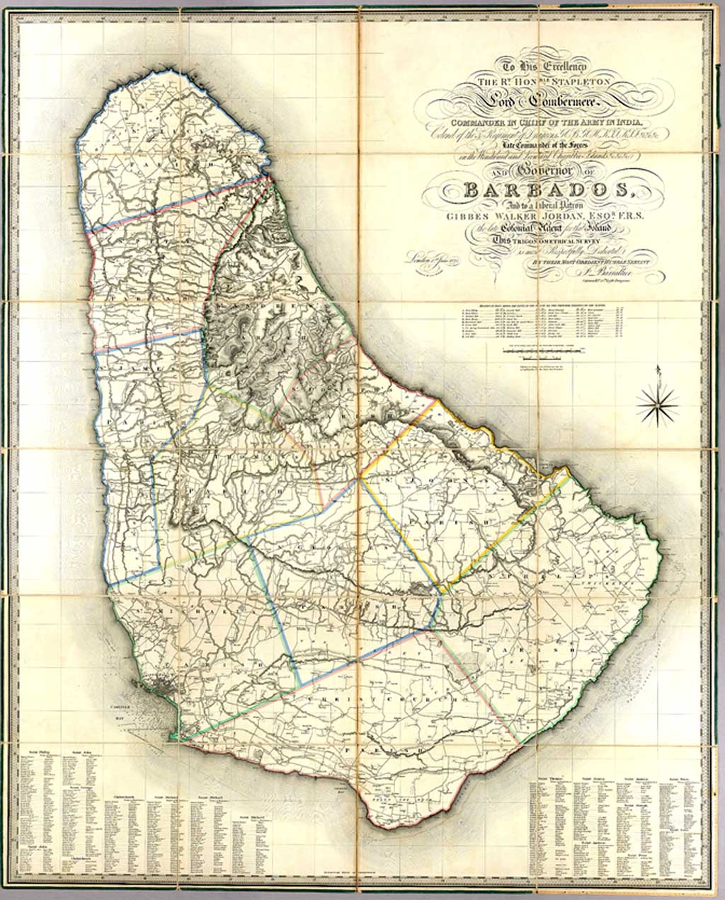
The JCB Library (John Carter Brown)
1825 version with an overlay showing details of 109 of the 416 estates
Listing of estates on Barrallier Map
The National Archives – Kew

UCL – Legacies of British Slave-ownership
The National Archives – Kew

with an overlay showing details of 109 of the 416 estates
UCL – Legacies of British Slave-ownership
The National Archives – Kew
1825 Capt. F de Barrallier- Trigonometrical Survey of Barbados
with an overlay showing details of 109 of the 416 estates
UCL – Legacies of British Slave-ownership
The National Archives – Kew
The above map on the UCL – Legacies of British Slave-ownership website uses a copy of the 1825 Ballailer Trigonometrical Survey of Barbados that has been georeferenced. This is what Rachel Lang of UCL – Legacies of British Slave-ownership project told us:
The 1825 Barrallier Trigonometrical Survey of Barbados has been georeferenced to correct inaccuracies in the original map (you can see that the distances in the north of the islands are consistently shorter than Barrallier’s measurements). The map was then superimposed on a transparent satellite image so that the location of the 109 estates are located in their true postion.
53 [1828] NORIE (J. W.)
The Island of Barbadoes. revised. A New Edition, London, January lst, 1828. 47 X 63 ½ cms.
Inset: Plan Of Carlisle Bay; and appearance of North Point and Pelican Island. Despite the title this appears to be the first edition.

Photograph from: “The Printed Maps of Barbados” – Tony Campbell
54 [1828 to 1857] ADMIRALTY CHART – no image available
Barbados. Charles Wilson, late J. W. Norie & CO., London, March 31, 1857. 44½ x 63½ cms.
A slightly altered re-issue of the 1828 Norie.
[No image sourced – please contact Jim Webster via the BajanThings Contact Burts link to assist]
55 [1835] SOCIETY FOR THE DIFFUSION 0F USEFUL KNOWLEDGE
Barbados settled 1605. 6 X 5 cms.
Inset on a sheet entitled: The British Islands in the West Indies. 39½ x 31½ cms. (containing 15 maps and insets) Published 1st March 1835 by Baldwin & Cradock, London. Engraved by J. & C. Walker.
In: S.D.U.K. A series of maps, modern and ancient under the superintendence of the Society for the Diffusion of Useful Knowledge [1829-35]. Other issues: 1844, 1845, 1848, 1852, 1853, 1860, 1871.

Geographicus Antique Maps
W [1837] HALLIDAY (SIR ANDREW)
Geological Map of Barbados produced by Sir Andrew Halliday KH, MD, FRSE as Deputy Inspector-General of hospitals in the West Indies from 1832 to 1837. Halliday was a Royal physician to William IV and Queen Victoria, military surgeon, author and reformer. He returned to his home in Dumfries in 1837 because of ill health. He died at Huntingdon Lodge in Dumfries on 7th September 1839.
Lithograph: Standing & Co. Litho 77, Cornhill
Legend:
- No 1 The earliest formations and H the Highest Peak
- No 2, 3 & 4 denote the subsequent formations.
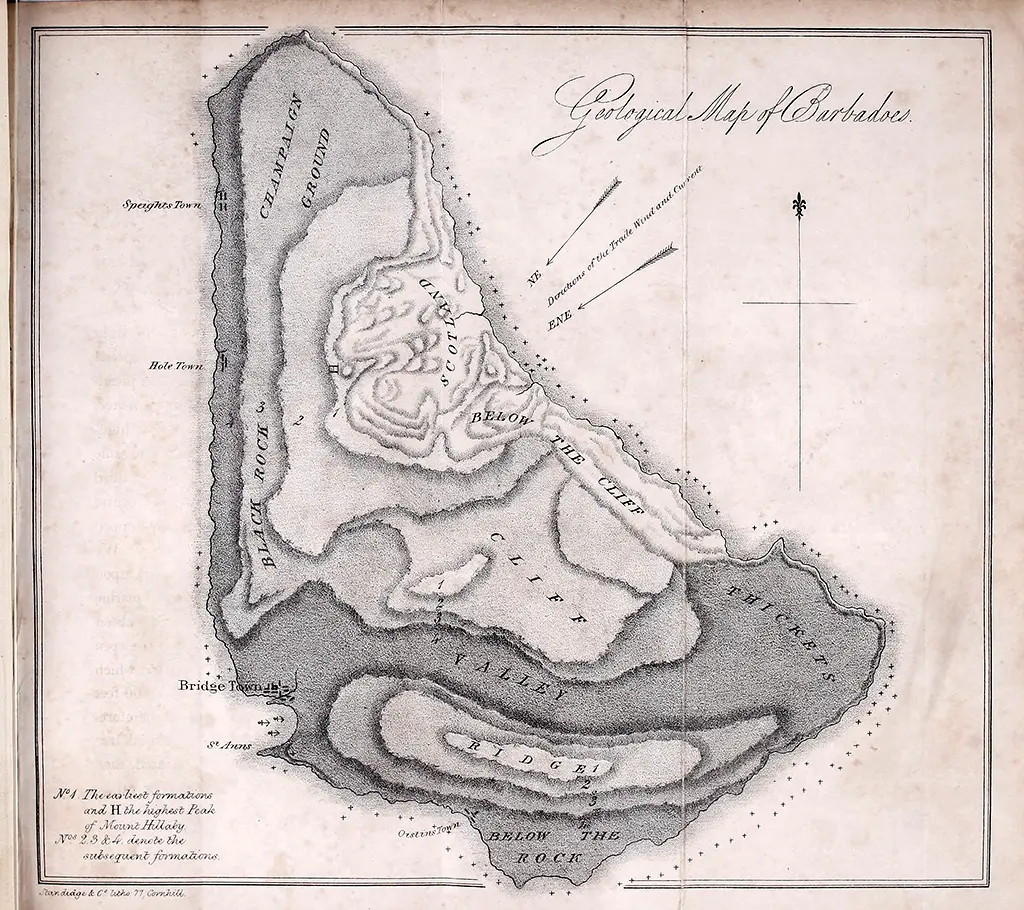
Wellcome Collection
Library of Congress

Wellcome Collection
Library of Congress
Published in: The West Indies – The Natural and Physical History of the Windward and Leeward Islands; with some account of the Moral, Social and Political Condition of Their Inhabitants, Immediately Before and After the Abolition of Negro Slavery by Sir Andrew Halliday, Deputy Inspector General of Army Hospitals (map inserted after page 24).
Published in London by John William Parker, West Strand
Suffering from gout, Halliday was able to get assigned to a position in the West Indies to help with his recovery. He arrived in Barbados Thursday, 5th December 1833 and departed Monday, 17th March 1834. Upon his return to England he wrote a book about his observations both on Barbados and in other British colonies during the period immediately following emancipation. Geology was an area he in which he had a strong interest along with many other areas of life at that time including religion, post emancipation life, and conditions of troops in the British Garrison. In the book he gives a detailed description on the geological formation of Barbados.
Halliday, was very familiar with the work of previous writers on Barbados it is very possibly he might have used the Lucas 1823 map as a reference or template for his Geological Map of Barbados.
W [1845] MOODY (THOMAS) Lt. Col.
Barbados Barracks. Sketch showing the positions of the several Guard Houses in the St. Anne’s Garrison and the vicinity: with the Canteens and Private Shops for the sale of Spirits and Groceries. To accompany Lt. Colonel Moody’s letter No. 462 dated 21st July 1845.
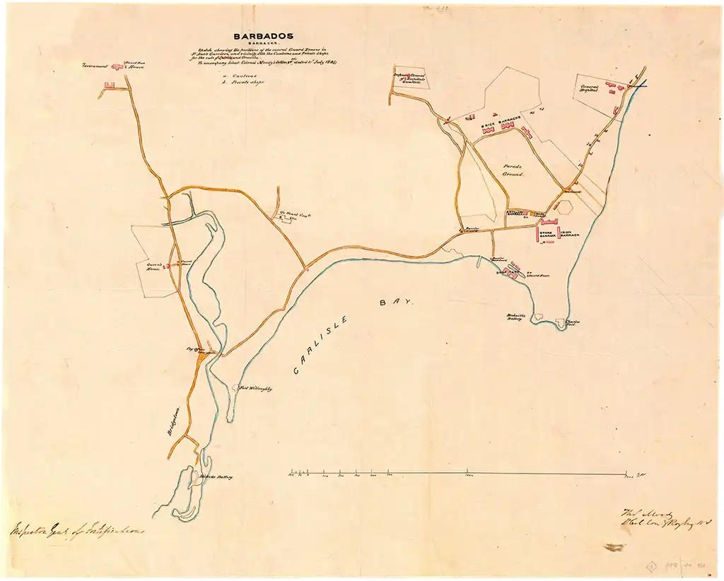
National Archives, Kew, UK, Catalogue reference: MFQ 1/720/11
Click here to see a high resolution image
Here is St. Ann’s Garrison drawn on stone by W. L. Walton of Hullmandel & Walton Lithographers (1843 – 1863) from a sketch by W. S. Hedges. This was one of a series of sketches, by Hedges which were published in Robert Schomburgk’s 1848 History of Barbados. Many of the buildings shown still exist to this day. Today the cane fields have been replaced by buildings.
This sketch was prepared at about the same time as Lt. Colonel Thomas Moody, Inspector General of Fortifications for the West Indies, produced his Barbados Barracks map.

56 [1847] WALSH (BLAYNEY Wm.) – no image available
Plan of the City of Bridgetown, Barbados, engraved Jas. Gardner. London. 93½ x 89 cms.
[No image sourced – please contact Jim Webster via the BajanThings Contact Burts link to assist]
57 [1847] SCHOMBURGK (SIR ROBERT H.)
A Topographical Map of the Island of Barbados Based upon Mayo’s Original Survey in 1721 and corrected to the Year 1846. 127 x 99 cms. Edward Stanford, London, 1847.
Inset: Section across the Island. Sir Robert Schomburgk was the author of the standard history of Barbados published in 1848.

Norman B. Leventhal Map & Education Center
58 [1850] MAYOCK (l. D.) – no image available
Geological Map of Barbados. This is the first geological map of the Island. 20½ x 19 cms.
[No image sourced – please contact Jim Webster via the BajanThings Contact Burts link to assist]
W [1851] WARD (W. C. ) Lt. Col.
Plan of Carlisle Bay Barbados
The existence of the following is not recorded either by Shilstone or by Campbell in their lists of the printed maps of Barbados:
1851. Ward, W. C. Plan of Carlisle Bay, Barbados. Shewing the City of Bridgetown, the Harbour, Bay, Road, 8: Garrison of St. Ann’s. 29 x 40 cm. [On sheet with] Plan shewing the Proposed Harbour of Refuge at Bridgetown, Barbados. 21 x 40 cm. J. Arrowsmith, Litho.
In: Gt. Brit. The Reports made for the year 1850 to the Secretary of State having the department of the Colonies; in continuation of the Reports annually made by the Governors of the British Colonies, with a view to exhibit generally the past and present state of Her Majesty’s colonial possessions. Transmitted with the Blue Books for the year 1850. London: William Clowes for Her Majesty’s Stationery Office, 1851.
Official reference: 1851 [1427] xxiv.
Reprinted by Irish Universities Press in Vol. 6 of its “Colonies.- General” series of British parliamentary papers.
Lt.-Col. W. C. Ward commanded the Royal Engineers, West Indies, and the plans are “signed” by him, the former on 7 May 1851 and the latter on 26 April and 7 May 1851. The plans illustrate a proposal to create a harbour of refuge and a coaling wharf, which would have entailed deepening the mouth of the Careenage by some 15 feet, removing a mangrove swamp from the River Road area and diverting the Constitution River. Convicts sentenced to hard labour were to carry out the work. The Secretary of State, while recognizing the value of the proposed facilities, offered no hope that her Majesty’s Government might finance the scheme.
The copy on which this description is based, an example of the original issue, was partially hand-coloured.
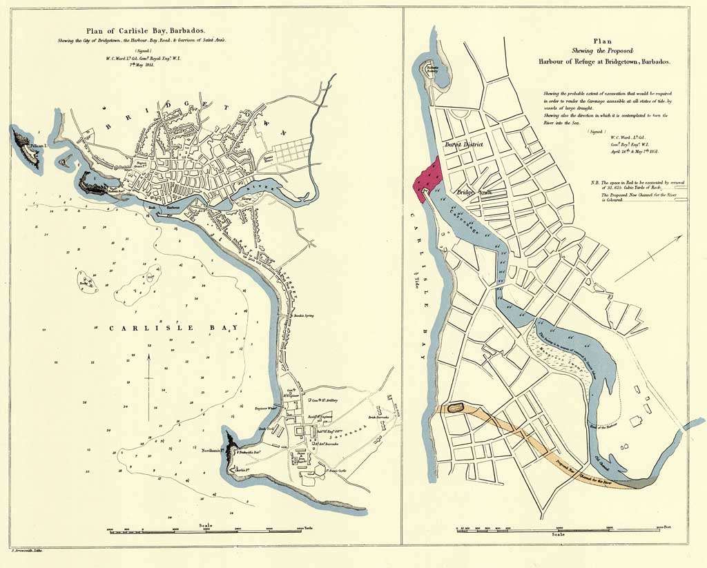
National Library of Australia


W [1853] PETERSON (AUGUSTS)
Tobago. (West Indies.) Barbados. (West Indies.) (Moravia Church establishments).
Lithe. by A. Peterson, 9, Charing Cross. (1853)
20 cm x 17 cm, Scale 1:338,000
From The Moravia Atlas, embracing statistics of the Church of the United Brethren in her home and foreign departments, compiled from the most recent and authentic sources, by the teachers of the Fullback Academy. 1853. Barbados Moravian Churches and their date of founding: Sharon (1794), Mount Tabor (1826), Bridgetown (1836), Clifton Hill (1841).

David Rumsey Map Collection Cartography Associates
59 [1856] ADMIRALTY CHART 2485 WALKER (J. & C.) – engravers
West Indies, Barbados from various authorities, engraved by J. & C. Walker.
Published at the Hydrographical Office July 31st, 1856. 48 x 62 cms.

Wikimedia Commons
60 [1859] TAYLOR (A.)
A Topographical Map of the Island of Barbados based on the survey taken by William Mayo, in 1721, corrected and improved to 1859, engraved by L. Becker. London, January lst, 1859. 69½ x 89 cms.
Inset: Two silhouettes of the island.

British Library
W [1860] REICHEL (LEVIN T.)
Map of Barbados published by Expedition der Missions-Verwaltung (Herrnhut)

The University of Florida Digital Collections (UFDC)
61 [1870] WELLER (E.) – no image available
A Topographical Map of the Island of Barbados. Based on the Survey Taken by William Mayo in 1721. 43 x 28 cms. Lithographed by Edward Weller, Red Lion Square, London. Bowen & Sons, Booksellers, Barbados, 1870.
The only recorded copy of this is in the possession of the Barbados Museum and Historical Society.
[No image sourced – please contact Jim Webster via the BajanThings Contact Burts link to assist]
62 [1871] ADMIRALTY CHART – no image available
West Indies – Barbados.
Carlisle Bay. Surveyed by Staff Commander J. Parsons and Navg. Lieuts. H. R. Harris and G. Stanley, RN. 1869. London, 5 April, 1871. 63½ x98 cms.
[No image sourced – please contact Jim Webster via the BajanThings Contact Burts link to assist]
63 [1873] ADMIRALTY CHART
Preliminary Chart. West Indies.
Barbados surveyed by Staff Commander J. Parsons, R.N. Assisted by Navigating Lieuts. H. R. Harris & G. Stanley, RN, 1869. 64½ x 97½ cms. Published at the Admiralty, 7th April, 1873.
(The inland details are incomplete, notably in the hilly N.E.).

sent to BajanThings by John Knox
64 [1873] ADMIRALTY CHART
Barbados.
Surveyed by Staff Commander J. Parsons, RN. Assisted by Navigating Lieuts. H. R. Harris and G. Stanley. RN, 1869. Admiralty, London, 26th Feb., 1873. 64½ x 98 cms.
Inset: Silhouettes, View from the North West, View from the Southward.
This is the completed version of the above, and as the Preliminary chart post- dates this we may assume that one of the dates is a mis-print. This was a complete survey of the coasts and inland regions of Barbados, the Island agreeing to pay the cost of the land survey, which was the first since Mayo’s of 1721. The hydrographic survey was the first ever of the Island and previously soundings had only been shown for Carlisle and Oistin Bays.

Photograph from: “The Printed Maps of Barbados” – Tony Campbell
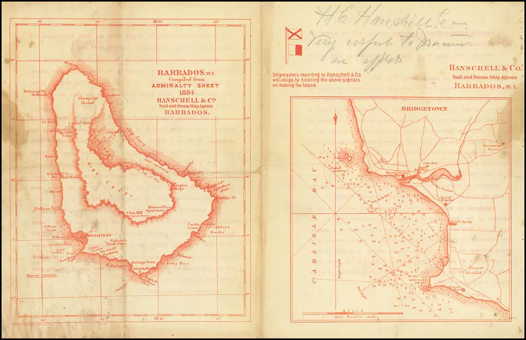
W [1884] ADMIRALTY CHART – BARBADOS & BRIDGETOWN, HANSCHELL & Co.
Sailing directions for Barbados. W.I. Compiled from Admiralty Sheet 1884 by Hanschell & Co. Sail and Steam Agents Barbados.
A pair of maps, with sailing directions on the verso, illustrating the island of Barbados and its capital, Bridgetown – 16 x 9.5 inches (both together).
Valdemar Hanschell, a Danish merchant and sea captain from St. Thomas in the Danish Virgin Islands, established a chandlery business in Barbados in 1884. This business initially supplied ships with essential items such as ropes, sails, and provisions. By the early 20th Century, it was advertising its services as Steamship and Insurance Agents, Charting Brokers and Commission Merchants, with “Ships Stores and Outfits of Every Description Supplied.” As the company grew, it diversified into the local liquor market, launching Cockspur rum, which quickly became the best-selling rum on the island. The company evolved into Hanschell Inniss Ltd., which continues to blend and bottle rum at its operations in Fontabelle, north of Bridgetown. Cockspur rum, produced since 1884 at the famous West India rum factory, is now shipped worldwide. In 1971, Hanschell Inniss Ltd. was formed through the merger of James H. Inniss & Son Ltd. and Hanschell Larsen & Co. Ltd., and was later acquired by J.N. Goddard & Sons Ltd. in 1974.
Barry Lawrence Ruderman Antique Maps Inc.
Barry Lawrence Ruderman Antique Maps Inc.
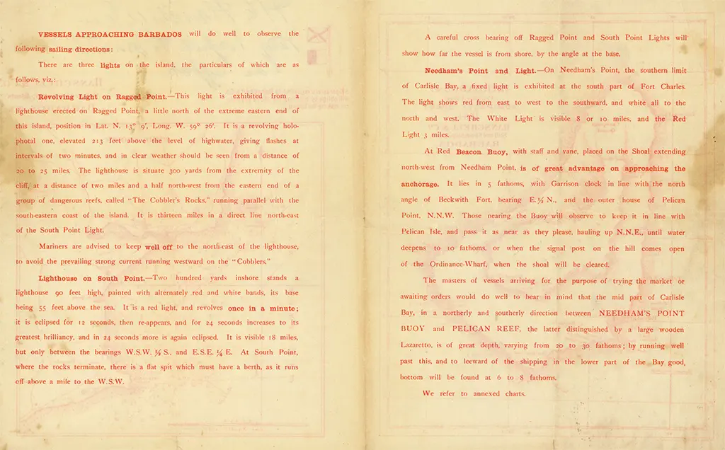
The following is a transcription of the sailing directions on the verso of this 1884 Barbados Admiralty chart of Barbados and Bridgetown:
VESSELS APPROACHING BARBADOS will do well to observe the following sailing directions:
There are three lights on the island, the particulars of which are as follows, viz.
Revolving Light on Ragged Point – This light is exhibited from a lighthouse erected on Ragged Point, a little north of the extreme eastern end of this island, position in Lat. N. 13° 10′ Long. W. 59° 30′. It is a revolving holophotal one, elevated 213 feet above the level of highwater, giving flashes at intervals of two minutes, and in clear weather should be seen from a distance of 20 to 23 miles. The lighthouse is situate one yard from the extremity of the cliff, at a distance of two miles and a half northwest from the extreme end of a group of dangerous rocks, called “The Cobbler’s Rocks,” running parallel with the southeastern coast of the island. It is thirteen miles in a direct line northeastern of the South Point Light.
Mariners are advised to keep well off to the northeast of the lighthouse, to avoid the prevailing strong current running westward on the “Cobblers.”
Light on South Point – The Light—a fixed catadioptric, stands a lighthouse 70 feet high, painted with alternately red and white bands, the base being 54 feet above the sea. It is a red light, and revolves once in 1 minute; it is eclipsed for 15 seconds, reappears, and gives two 8 seconds flashes to its greatest brilliancy, and in 42 seconds more is again eclipsed. It is visible 15 miles, but only between the bearings W.S.W. ¼ S. and E.S.E. ¼ E. At South Point, where the rocks terminate, there is a flat spot which must have a berth an one half off shore a mile to the W.S.W.
A careful cross-bearing of Ragged Point and South Point Lights will show how far the vessel is from shore by the angle at the time.
Needham’s Point and Light – On Needham’s Point, the southern limit of Carlisle Bay, a fixed light is exhibited at the mouth part of Fort Charles. The light shows red from east to west to the southward, and white to the north and west. The White Light is visible 8 or 10 miles and the Red Light 8 miles.
At Red Beacon, Buoy, with staff and vane, placed on the Shoal extending north from Needham Point, is of great advantage on approaching the anchorage. It lies in 5 fathoms, with Garrison clock in line with the north west of Beckwith Fort, bearing E.B.N., and the outer house of Pelican Point N.N.W. Those entering the Buoy will observe to keep it in line with Pelican Isle; and pass it as near as they please hauling up N.N.E., until water deepens to no fathoms, or when the signal post on the hill comes open of the Ordnance Wharf, when the shoal will be cleared.
The masters of vessels arriving for the purpose of trying the market or awaiting orders would do well to bear in mind that the two third part of Carlisle Bay, in a northerly and southerly direction between NEEDHAM’S POINT BUOY and PELICAN REEF, the latter distinguished by a large wooden beacon, is at present (although varying from 9 to 10 fathoms), by running well past this, and to leeward of the shipping in the lower part of the Bay, good bottom will be found at 4 to 5 fathoms.
We refer to amended charts.
[1884] ADMIRALTY CHART – BARBADOS & BRIDGETOWN – compiled by Hanschell & Co. Sail and Steam Agents Barbados W.I.
S52 [1887] ANCIAUX (GABRIEL) – no image available
Island of Barbados.
In The Barbados Business and General Directory for 1887 . . . By Gabriel Anciaux, Editor, Proprietor, Charles Packer Bowen, co-editor, Publisher, Barbados, 1887. 12½ X 16½ ins.
An outline map drawn and printed by the cyclostyle by G. Anciaux, showing the division of the parishes, the railroad, and main public roads, bays and features of the coastline.
[No image sourced – please contact Jim Webster via the BajanThings Contact Burts link to assist]
S53 [1890] HARRISON (J. B.) & JUKES-BROWNE ( A. J.)
F.G.S Geological Map of Barbados. Based on the survey made for the Admiralty by Staff Commander J. Parsons R.N. in 1869. Scale 1 1-3 ins. to a mile or 3960 feet to an inch. 25½ X 38½ inches.
This is the small Parsons map coloured so as to show the geological features of the Island, with an Index of colours indicating alluvium and blown sand, coral lime-stone, oceanic deposits, and the Scotland series. White lines indicating faults, red lines contours. The dip or inclination of strata shown by arrows.

The UK National Archives, Kew.
W [1895] LAURIE & Co. Ltd
Barbados W.I. Corrected and accurately reduced from latest Admiralty Chart 1895. Produced by: Laurie & Co. Ltd ship brokers, coaling and general commission merchants in Barbados.
This Laurie & Co. Ltd Barbados map was based upon the Admiralty Chart of 1895. It shows the main bays, reefs, signal stations, lighthouses and the route of the railway from Bridgetown to Belleplaine.

Click here to see a high resolution image
S54 [1895] GOAD (CHAS. F.) – Civil Engineer
Bridgetown and Suburbs. Chas. F. Goad, Civil Engineer; London, 1895.
Scale 504 ft. [ = 1 inch.] 25 X 21 ins.
In a bound volume containing six plans of the city and suburbs showing general information regarding population, water works, fire appliances, prevailing winds, and height above sea level, as a guide to underwriters of fire insurance on the buildings within the areas.
Volume in the possession of the Agents of the Alliance Insurance Co. , Bridgetown in 1938.


The University of the West Indies Historical Collection (Mona, Jamaica)
The University of the West Indies Historical Collection (Mona, Jamaica)
British Library
The University of the West Indies Historical Collection (Mona, Jamaica)
The University of the West Indies Historical Collection (Mona, Jamaica)
British Library
The University of the West Indies Historical Collection (Mona, Jamaica)
British Library
The University of the West Indies Historical Collection (Mona, Jamaica)
The University of the West Indies Historical Collection (Mona, Jamaica)
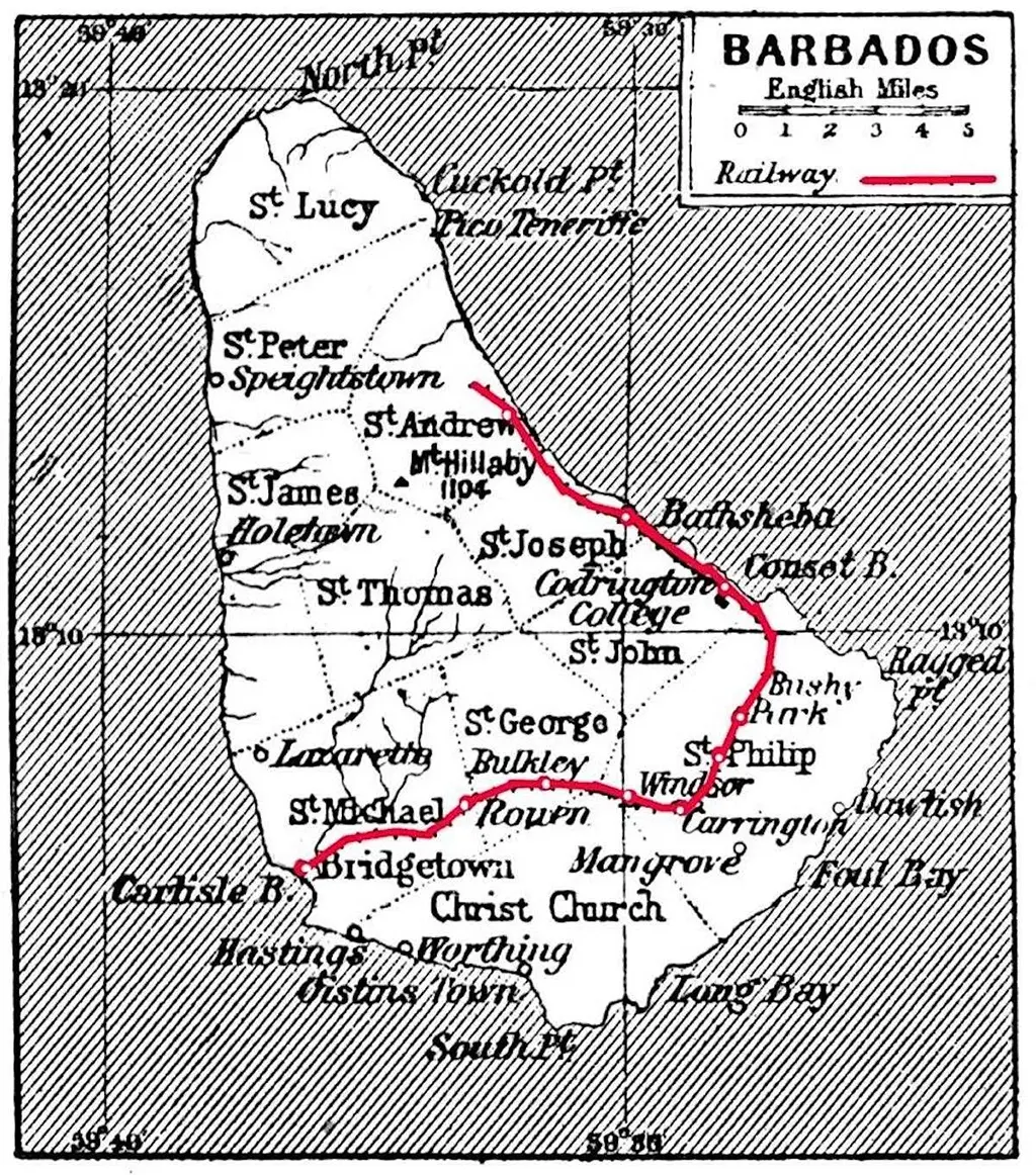
W [1877 to 1937] BARBADOS RAILWAY MAPS
The stations included:
- Bridgetown – 0 km (0.0 mi)
- Rouen – 4.0 km (2½ mi)
- Bulkley – 8.9 km (5½ mi)
- Windsor – 11.3 km (7 mi)
- – Branch to Crane – 14.3 km (8⅞ mi)
- Carrington – 14.5 km (9 mi)
- Sunbury – 16.1 km (10 mi)
- Bushy Park – 17.7 km (11 mi)
- Three Houses – 20.9 km (13 mi)
- Bath – 25.7 km (16 mi)
- Bathsheba – 32.2 km (20 mi)
- St. Andrew’s (Belleplaine) – 38.6 km (24 mi)
The University of the West Indies Historical Collection (Mona, Jamaica)

British Library
The University of the West Indies Historical Collection (Mona, Jamaica)

wikimedia.
Google Books – Section II Chapter IV, The leeward Islands, Page 132 (map)
Google Books – Section II Chapter V, Barbados Page 198 (details of railway)

Digital Archive McMaster University Library


WikiMedia – Old maps of Barbados

For additional information on the Barbados Railway see the – Barbados Trailway Project:
- Bridgetown to Consett Bay map – 26km
- Consett Bay to Belleplaine map – 14.5km
- The Crane Branch map – 6.7km.
Also see: The Colin Hudson Great (Barbados) Train Hike.
This is: The Printed Maps of Barbados – Part 3: 1800 – 1900. Click here to go to the previous or next section of The Printed Maps of Barbados 1500s – 1980s: