The Printed Maps of Barbados 1500s – 1980s is in 5 sections: 1500s – 1700, 1700 – 1800, 1800 – 1900,1900 – 1980s & Addendums. This is: The Printed Maps of Barbados – Part 1: 1500s – 1700. The follow-on sections are:
- The Printed Maps of Barbados – Part 2: 1700 – 1800
- The Printed Maps of Barbados – Part 3: 1800 – 1900
- The Printed Maps of Barbados – Part 4: 1900 – 1980s
- The Printed Maps of Barbados – Part 5: Addendums
The Printed Maps of Barbados 1500s – 1980s, brings together the research of E. M. Shilstone, Tony Campbell, Alan Moss and Jim Webster.

- E. M. Shilstone published “A Descriptive List of Barbados Maps” in 1938 in the fifth issue of the Barbados Museum and Historical Society (BMHS) Journal. Eustace Maxwell Shilstone a Barbadian lawyer co-founded the Barbados Museum & Historical Society (BMHS).
- Tony Campbell authored “The Printed Maps of Barbados” in 1965, (Map Collectors’ Circle, No. 21). This was a key resource and inspiration for this project despite being out of print.
- Alan Moss contributed “Further Notes on The Printed Maps of Barbados” in BMHS Journal volumes XLI (1993) and XLV (1999).
With digital libraries now widely accessible, Jim Webster has expanded on their work, further enriching the collection of printed Barbados maps.
Sourcing Missing Maps, Additional Maps And Map Images
If you can help source images of any of the maps where there is no image or would like to suggest maps of Barbados that should have been included in “The Printed Maps of Barbados 1500s – 1980s” please contact me by either leaving a comment below or clicking on the BajanThings Contact Burts link and choosing from the Subject drop-down: “Barbados Maps – Forward to: Jim Webster”.
Jim Webster – 15th February 2020 (updated February 2025)
Old, historical and antique printed maps of Barbados: 1500s – 1700
The old, historical and antique printed maps of Barbados are listed chronologically. Maps referenced in Tony Campbell’s book start with a number. Maps referenced by Eustace Shilstone start with a “S”. Other interesting maps added by Jim Webster are denoted with a “W”.
- W [c.1510] EGERTON PORTOLAN CHART
- W [1516] MAGGIOLO (VESCONTE)
- W [1569] MERCATOR (GERARDUS)
- W [1589] BOAZIO (BAPTISTA)
- W [1632] CARDONA (NICOLÁS)
- W [1646] HAPCOTT (JOHN)
- 1 [1657] LIGON (RICHARD)
- 2 [1674] LIGON (RICHARD)
- 3 [1671] OGILBY (JOHN)
- 4 [1672] BLOME (RICHARD)
- 5 [1676] SPEED (JOHN)
- 6 [1676] SPEED (JOHN) – no image available
- 7 [1680] MORDEN (ROBERT)
- 8 [1681] FORD (RICHARD)
- 9 [1681-1682] FORD (RICHARD)
- 10 [1682] SELLER (JOHN)
- W [1684] SLOANE MANUSCRIPTS
- 11 [1686] SELLER (JOHN) – no image available
- 12 [1689] THORTON (JOHN) & FISHER (WILLIAM)
- W [c. 1690] HACK (WILLIAM)
- 13 [1695] COPENS (SAMUEL)
- 14 [1696] LEA (PHILLIP)
Reference # (Numbers):
Map images from Campbell’s original book have a Plate # and reference No. #. Additional maps, which Campbell described and for which we’ve now added an image have a reference No. # only. The reference # correlates to the map description which are listed chronologically.
Maps referenced by Shilstone, in 1938, but not included in Campbell’s book have been added with a reference # beginning with “S”. eg. S20 would have been the 20th map on Shilstone’s list.
Moss intended that his work: “Further Notes on The Printed Maps of Barbados“, written 30 years after Campbell’s, should be read in conjunction with: “The Printed Maps of Barbados“. Alan Moss’ notes have been included in an indented quote block.
Maps without a plate or reference # have been added and inserted chronologically by Jim Webster in 2020 and denoted with a W.
Coloured Maps:
Prior to the 19th century maps were printed in black and white. In some instances hand colouring was added, after the printing, to enhance readability and appearance. If colouring was done, soon after printing, it was called original or contemporary colour. Colours added later were referred to as modern colour.
Laws of Carto-bibliography:
- Each printed map is an impression made by the transfer of ink from a unique printing platform or group of platforms (usually woodblock, copper plate or lithographic stone).
- The piece of paper we are looking at is no more than a reflection, literally a mirror-image, of a wooden, metal or stone printing platform, which was present in a particular workshop at a particular time.
The carto-bibliographer’s primary task is to recount the life history of a printing platform – the intentional and accidental changes made to it – by attempting to place in order a series of impressions pulled from it.
Tony Campbell “Understanding Engraved Maps“
Our thanks to Tony Campbell for supporting this transcription effort and for giving permission to re-publish “The Printed Maps of Barbados” which forms the basis for this project. You can follow Tony Campbell on Twitter: @portolanchart01.
Tony Campbell is an independent researcher who, for many years has been studying portolan charts. From 1987-2001 he was the Map Librarian at The British Library and is the chair of Imago Mundi Ltd, which has responsibility for Imago Mundi: The International Journal for the History of Cartography and for the coordination of International Conferences on the History of Cartography. We were able to contact Tony in 2018 to learn more about his work and the Barbados map project. He says:
…working up the carto-bibliography of Barbados was my very first foray into map history, done just a few months after I joined the firm of Francis Edwards Ltd, working with R.V. Tooley (author of Maps and Map-makers). The possibilities became immediately apparent when I pulled out the scores of maps of Barbados in the West Indies folder. That enabled me to sort out the different map ‘plates’, and the ‘states’, i.e. altered forms of each, especially of the small Moll maps. If you want to delve into that a bit you might find my article, “Understanding engraved maps“, a useful reference.
Tony Campbell
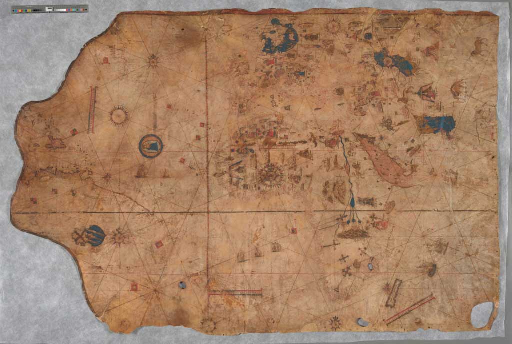
W [c.1510] EGERTON PORTOLAN CHART
Tony Campbell writes in the Map Collectors’ Circle No.21: The Printed Maps of Barbados, 1967, that the earliest portrayal of Barbados is in MS 2803, in the Egerton collection preserved in the British Library. This Portolan Atlas made around 1510 shows the West Indies and northern coast of South America in folios 7v-8. Barbados is illustrated in approximately the correct position south east of St. Lucia, and is named La Barbata.
The image below is an early photographic facsimile composite made by the early map expert Edward Luther Stevenson around 1910 or 1911. 17.5” x 10.5”.
In Atlas of Portolan Charts: Facsimile of Manuscript in British Museum (the preparation for which was certainly tied to the production of the present facsimile) Stevenson wrote:
Although neither signed nor dated, the several charts exhibit certain features which suggest the authorship of Vesconte de Maiollo, and in the astronomical tables, on fol. 11b, an argument may be found for assigning it to the year 1508. The historian Henry Harrisse thought it might be 1507 but Johannes Denucé showed that the New World nomenclature was based to a considerable extent on the 1508-09 voyage of Juan Dias de Solis and Vicente Pinzon, which gives 1510 as the most probable date for such a map to have been made in Italy. There is no trace in the detailed charts of Balboa’s discovery of the South Sea in 1513, which sets a limit to the time when the maps were made. Cortesao followed Denucé in dating it 1510 and there can be no doubt that this date is a dose approximation to the year it was drawn. Whoever the author may have been, he must be credited as one possessing the skill of an expert draughtsman, the good judgment of an intelligent map-maker, and the knowledge of a geographer who endeavoured to keep himself informed concerning the most recent discoveries.
Barry Lawrence Ruderman Rare Maps
Click here to see an excerpt of: Edward Luther Stevenson 1911 paper on the Atlas of Portolan Charts which was purchased by the British Museum in 1895.

Barry Lawrence Ruderman

Barry Lawrence Ruderman

W [1516] MAGGIOLO (VESCONTE)
Portolan Chart 102 x 155 cm on parchment skin.
World chart, from eastern coasts of America to India. Red border at top edged by black band that continues around left side, no borders on bottom or right. Black and red ink for nomenclature in a minuscule hand with area names in gothic script; American coast, Scotland, and England outlined in colour (very faded), other land masses in black ink only; 10 compass roses with usual 32 rhumb line network in black, red and green ink for the principal directions; latitude scale numbered from 40° S to 67° N, no longitude; four unnumbered scales of distance; decorated with imaginary animals, kings in pavilions, vignettes of cities, banners, three wind-heads, and a large medallion of the Virgin and Child. Unbound: formerly rolled, now flattened and kept in a modern case. Inscribed “Vesconte de Maiollo ianuense,” Naples, 7 May 1516.
The Huntington Library

My Old Maps

The Huntington Library
W [1569] MERCATOR (GERARDUS)
Gerardus Mercator was a 16th-century geographer, cosmographer and cartographer from the Flanders. He is most renowned for creating the 1569 world map based on a new projection which represented sailing courses of constant bearing (rhumb lines) as straight lines—an innovation that is still employed in nautical charts.
Nova et Aucta Orbis Terrae Descriptio ad Usum Navigantium Emendate Accommodata (Latin for “New and more complete representation of the terrestrial globe properly adapted for use in navigation”). 1 roll of 18 assembled threads 200 x 133 cms.
Textual insert: Maranon fluvius inventus fuit a Vincentio Yanez Pincon an: 1499, et an: 1542 totus a foutibus fere, ad ostia usque navigatus a Francisco Oregliana leucis 1660, mensibus 8, dulces in mari servat aquas usque ad 40 leucas. (The River Maranon was discovered by Vicente Yanez Pincon in 1499, and in 1542 it was descended in its entirety, almost from its sources to its mouth, by Francisco Oregliana, over a course of 1,660 leagues during 8 months. It maintains its sweet waters in the sea for 40 leagues from the coast.)
The land mass, east of Barbados, was drawn on a number of the early maps and was possibly copied from one to another.

Gallica
Wikipedia
As far back as 1569 when Gerardus Mercator created his world map, the body of water partially enclosed by the southern part of north America, the eastern coast of Mexico and the island of Cuba was called the Golfo Mexicano.
Spanish explorers, who were the first Europeans to extensively map the area, named the gulf based on their interactions with the Aztec people, who lived in the region around present-day Mexico City.
On 20th January 2025, President Trump signed Executive Order 14172 (“Restoring Names That Honor [US spelling] American Greatness”) which for Americans changed the name of the Gulf of Mexico to the Gulf of America. Google and Apple who are American companies, have both followed President Trump’s directive and on their mapping apps renamed the Gulf of Mexico to the Gulf of America.
Fun Fact: The name Gulf of America was first used by Russian Governor-General Nikolay Muravyov-Amursky of Eastern Siberia in 1859, not for a location in the Americas, but for a bay in the Sea of Japan. The bay was named after the Russian steam corvette Америка (Amerika) that discovered the bay. In 1972, the Russian Soviet Federative Socialist Republic changed the name of the Gulf of America to Nakhodka Bay to the eliminate a perceived reference to the United States, a geopolitical rival of the Soviet Union.

Gallica
Wikipedia
Although Richard Ligon’s map of 1657 is often referenced as being the first separate map of Barbados, Barbados had begun to appear on Spanish and Portuguese maps, of the West Indies, by the early 1500’s.
W [1589] BOAZIO (BAPTISTA)
Map inscription: The Famouse West Indian voyadge made by the Englishe fleete of 23 shippes and Barkes wherin weare gotten the Townes of St. Iago: Sto. Domingo, Cartagena and St. Augustines … Newlie come forth by Baptista B.
In 1585, Sir Francis Drake led a flotilla of ships to the West Indies to harass Spanish settlements. The English fleet captured Santo Domingo on Hispaniola, Cartagena, Colombia, and St. Augustine, Florida. On the return voyage, they picked up passengers from the Roanoke colony.
Map showing Sir Francis Drake’s West Indian voyage of 1585, including the Atlantic Ocean, parts of North America, South America, Europe, and Africa. Cartographic elements include compass rose, scale, Ferro meridian, equator, sea banks or shoals, and major rivers of North and South America. Decorative elements include ships, “sea Connye” [fish], and flags of various European countries laying claim to lands.
The creator of this map is probably Baptista Boazio, an Italian artist resident in London. Boazio is well known for his manuscript maps, although there is no known engraved work by him. The signature on this map, “Baptista B.,” is the only example of his [partial] name on an engraved work. The map is often referred to as the “Drake map.” This map is one of four illustrating Drake’s successes. It may have been published in Leiden.

The John Carter Brown Library
This map by Baptista Boazio combined with the diaries of Aymas Preston is thought to be the inspiration for Charles Kingsley’s historical novel Westward Ho! in 1855. The hero character Amyas Leigh is based on the life of Amyas Preston who took part in The Preston–Somers expedition during the Anglo-Spanish War. The English expedition headed by George Somers and Amyas Preston sailed to the Spanish Main intending to support Sir Walter Raleigh’s expedition which set out at the same time.
W [1632] CARDONA (NICOLÁS)
Isladel Barbado
Descripciones geográphicas e hydrográphicas de muchas tierras y mares del Norte y Sur en las Indias, en especial del descubrimiento del Reino de la California (Geographic and hydrographic descriptions of many northern and southern lands and seas in the Indies, specifically the discovery of the kingdom of California), written by captain Nicolás de Cardona after his expedition of 1614.

Wikimedia
Biblioteca Digital Hispánica
Biblioteca Nacional de España
W [1646] HAPCOTT (JOHN)
Fort Plantation
“This plott representeth the forme of three hundred acres of Land part of a Plantation called the Fort Plantation of which 300 acres Cap. Thos. Middleton of London hath purchased …”
This estate was surveyed on October 10, 1646, and drawn in the style of the Thames School sometime between 1647 and 1677. Fort Plantation, the subject of the survey, was in existence as early as 1631. This survey gives interesting indications of land use: “Fallen land” refers to areas cleared for agriculture, specifically sugar cane, and “Potato peece” indicates an important food source for the English. The legend refers to Mr. Wright’s plantation “taken too farr into this land” probably referring to encroachment by neighbours before all boundary lines were carefully surveyed. Saint James Church was built in 1628; St. James Anglican church still remains in the same location.

The JCB Library
The John Carter Brown Library

Source Douglas V. Armstrong & Matthew C. Reilly: The Archaeology of Settler Farms and Early Plantation Life in Seventeenth-Century Barbados published online: 1st September 2014.
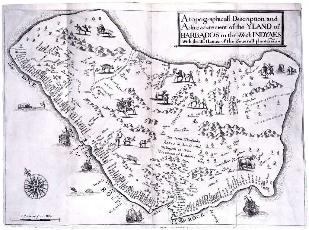
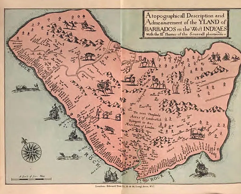
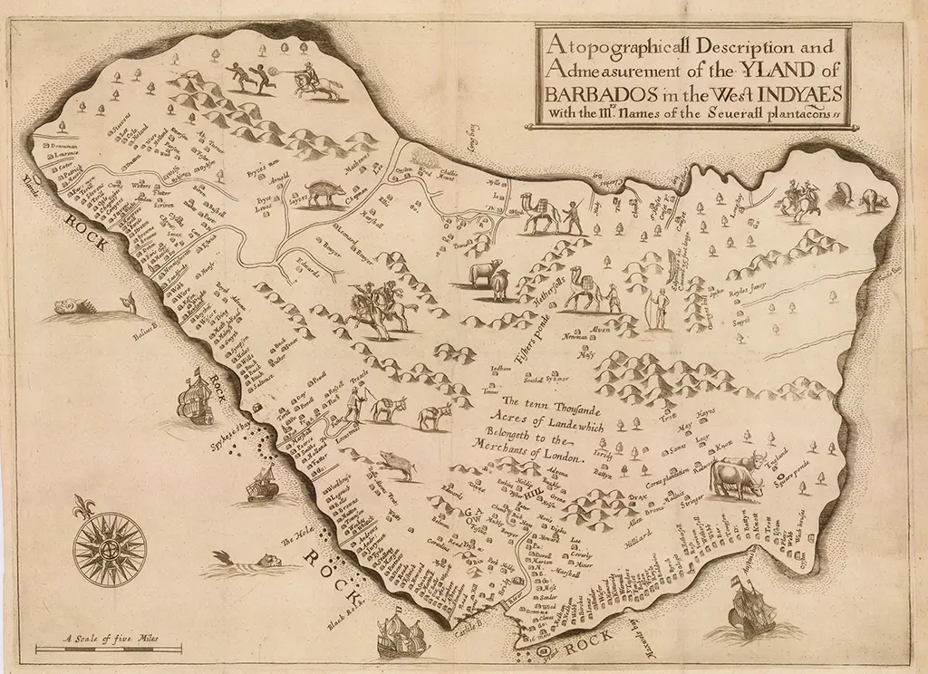
1 [1657] LIGON (RICHARD)
A topographicall Description and Admeasurement of the Yland of Barbados in the West Indyaes with the Mrs. Names of the Seuerall plantacons. 51½ x 36½ cms.
ln: Ligon (R) A True & Exact History of the Island of Barbados, London, 1657, Second Edition 1673:
Richard Ligon set sail in the “last scene” of his life for Barbados via Cape Verde, “where we were to trade for Negroes, horses and cattle; which we were to sell at Barbadoes.” When he arrived in 1647 he found the island still overgrown with primaeval forest, which made penetration of the hinterland very difficult. At this time very little was known besides the coast-line and even about this there was considerable doubt as Ligon describes—“the length and breadth of this Island, I must deliver you only upon trust; for, I could not go my self about it, being full of other business; but I had some speech with the antientest, and most knowing Surveyer there, one Captain Swan, who told me that he once took an exact plot of the whole Island, but it was commanded out of his hands by the then Governour, Sir Henry Hunks, who carried it into England; since which time, neither himself, nor any other, to his knowledge, had taken any; nor did he believe, there was any extant.”
Despite this, Ligon’s map, the first separate map of the island (included to illustrate his book, which was written in the Upper Bench Prison where he was thrown for debt on his return to England in 1650) is in the main a faithful representation of the island’s outline, although it gives very little inland detail. The northern half is exaggerated at the expense of the south, but the main failing is in the scale. Captain Swan had found among his papers and passed on to Ligon his estimates of the island’s size, namely that it was 28 miles long and between 12 and 17 miles wide. However, while claiming to believe these figures, Ligon makes the island 32 miles long according to the scale of miles, which is a third more than its correct length.
The map’s main purpose is to show the plantations, which at this date were along the west and south coasts. Beside each name is a sign, somewhat like a rabbit hutch, to mark the approximate size of the estate. In the middle of the map appears the lettering, “the tenn Thousande Acres of Lande which Belongeth to the Merchants of London”, a reference to the land leased by Carlisle to a group of London merchants. Scattered about the inland are the figures of settlers (sometimes depicted in full armour on horseback) servants (criminals and others, often sold for 7-year terms) and negro slaves. The animal life is also illustrated; cows, pigs, sheep, asses, hogs and camels. Besides the hogs, which were there when the settlers arrived, the other animals had been brought to the Island, including the camels which were used as beasts of burden on the plantations.
The issue appearing in the 2nd edition (1673) is distinguished from the first (1657) by the names of a few additional coastal features, e.g. Fowle Bay, Long Bay, and Balises B. Only one further inland feature appears to have been identified, however, Io. Read’s plantation to the north of Speightstown.
A. Moss
Yale Library
INTERNET ARCHIVE
The above coloured Richard Ligon 1657 appeared in the 1907 Pocket Guide to the West Indies by Algeron Aspinal. In subsequent editions of the pocket guide they returned to using a copy the original non-coloured map.
The Map House
Leventhal Map Centre
British Library
2 [1674] LIGON (RICHARD)
Description Topographique et mesure de l’isle des Barbades aux Indes Occidentalles avec les Noms de ceux a qui appartienent les habitations. 52 x 38 cms.
In: Ligon (R.) Histoire de l’lslc des Barbades; from, Justel ( H.) Recueil de divers Voyages faites en Afrique et en I’Amerique, Paris, I674.
Ligon’s map re~engraved with the same information but lacking all the decorative details, even the compass rose.
The imprint of Justin’s Receuil de divers voyages … is Paris: Chez Louis Billaine, …1674.
A second issue, Paris: La Veuve Ant. Cellier, 1684, also contained the map. Since Fowle Bay and Balises B. were named, the map can be deduced to have been copied from the second issue of the English edition.
A. Moss

Huntington Library
Old World Auctions
3 [1671] OGILBY (JOHN)
Novissima et Acuratissima Barbados Descriptio. 35½ x 29 cms.
In: Ogilby (1.) America, Being the latest and most accurate description of the New World, [London] 1670. Another issue 1671.
An outline map showing the coastal features but without any inland detail. Typical fauna is depicted, e.g. Pine Apple, sugar cane, cabbage tree, papaw, Beunawno, indian corn. In the centre is a vignette of a sugar mill. The map is not based on Ligon and there are many differences. The island’s length, according to the map’s scale has been reduced to 23 miles, and there is information additional to that on Ligon’s map. Ogilby was never on Barbados, and his sources for this map remain unknown.

Shilstone ascribes the map to a work by Ogilby entitled Atlas Americana (1671), but neither STC2, Katherine Van Eerde’s John Ogilby and the taste of his times, nor any of several other sources checked acknowledges the existence of an Ogilby work of this title. Despite differences in the sub-title also, therefore, we are compelled to assume that, like Campbell, Shilstone was referring to Ogilby’s America.
Van Eerde and the John Carter Brown Library indicate that America was essentially an embellished translation of Arnoldus Montanus’ De nieuwe en onbekenade weereld (Amsterdam: Jacob Van Meurs, 1671), which in itself brings into question the accuracy of the 1670 publication date found on the title-page of the first issue of America. The John Carter Brown Library further notes that the map of Jamaica which is one of the three maps present in Ogilby but not in Montanus is dated 1671, and accordingly it ascribes to this issue a publication date of 1671.
In the above issue the final, unnumbered leaf of “Descriptions for placing the Whole-sheet prints in the Volume of America does not call for a map of Barbados, although the map is indeed present, located between pages 376 and 377. A modified description appears in two later issues in which the Barbados map is called for, at page 376.
Three issues of America bearing the date of 1671 on the title-page have been identified, all of them differentiated from the “1670” issue by changes in the sub-title and the imprint. The sub-title of the “1670” issue begins: being the latest, and most accurate description of the new world; and the publisher statement of the “1670” issue reads: Printed for the Author. In what is presumably the earliest of the issues the Barbados map is neither present nor called for in the “Description” leaf. In the later two issues, the map of Barbados is called for in the “Description”, but in one case it is present while in the other it is not.
A. Moss

David Rumsey Map Collection
4 [1672] BLOME (RICHARD)
A Mapp of the Island of Barbados Taken from the latest Survey By Ric. Blome 1672. 17 x 17½ cms.
In: Blome (R.) A Description of the Island of Jamaica with the other Isles and territories in America, to which the English are related. . Printed by T. Milbourn, and sold by the Book-sellers of London and Westminster, 1672 (NB. This map does not appear in an edition of the same year but with a different imprint).
Another edition: .l.P. for Dorman Newman 1678. French edition: Amsterdam 1688. The map is a copy of Ogilby.
The imprint given in Campbell for the 1678 edition of Blome’s work should be revised to: London: Printed by J.B. for Dorman Newman, 1678.
The “French edition: Amsterdam, 1688” referred to is in fact an edition of the later of Morden’s two maps (see 7, below).
A. Moss
Barry Lawrence Ruderman Antique Maps
5 [1676] SPEED (JOHN)
Barbados. T. Bassett & R. Chiswell. 50 x 19 cms.
In: Speed (J.) A Prospect of the most famous parts of the world, Bassett & Chiswell, London, 1676 (2 editions).
The Prospect first appeared in 1627 but the map of Barbados, on a sheet with Jamaica, was first included in this edition. The island’s outline is copied from Ogilby but the interior is dotted with trees and hills, that owe little to Ligon or geographical accuracy.
John Speed, historian and cartographer, died in 1629, thirty-seven years before the publication of the Barbados Map. Bassett and Chiswell copied Ogilby’s map, and included it in their 1676 edition or Speed’s Atlas. – Shilstone
Although Speed’s A Prospect of the most famous parts of the world bears its own title page and is separately paginated, it is usually encountered as the second part of his The Theatre of the Empire of Great Britain… together with A Prospect of the most famous parts of the world. Printed instructions to the Binder found on the title-page of the John Carter Brown Library’s copy of the Prospect state that the title-page is to follow the final folio (146) of The Theatre, which indicates that the two were intended to be bound together as a single volume.
Campbell makes reference to two 1676 editions of Speed’s Prospect, but I have been unable to find a record of more than one edition, although there is evidence of more than one issue in that in some copies the co-publisher is given on the title-pages of both the Theatre and the Prospect as Chiswel, whereas in others it is spelled Chiswell, either on the Prospect’s title page or on both title-pages.
The map was also issued separately from The Prospect, for a copy in the British Library bound in A Collection of Maps of Great Britain and Ireland by J. Speed, unlike the copies found in The Prospect, has no text on the version of the map. The imprint currently provided for the Collection by the British Library is T. Bassett and R. Chiswell: London (1666). It seems likely that this is the copy on which Shilstone based the entry at no. 7 in his list, which he dated to (1676?), presumably following the cataloguing of what was then the British museum.
A. Moss

David Rumsey Map Collection

Paulus Swaen
Another versions, 45 x 33 cms, is available from David Rumsey Map Collection
6 [1676] SPEED (JOHN) – no image available
Barbados. 12½ X 8½ cms.
In: An epitome of Mr. John Speed’s Theatre of the Empire of Great Britain and his Prospect of the Most Famous Parts of the World. Tho. Basset & Ric. Chiswel, 1676. The miniature Speed, first included in this edition.
[No image sourced – please contact Jim Webster via the BajanThings Contact Burts link to assist]
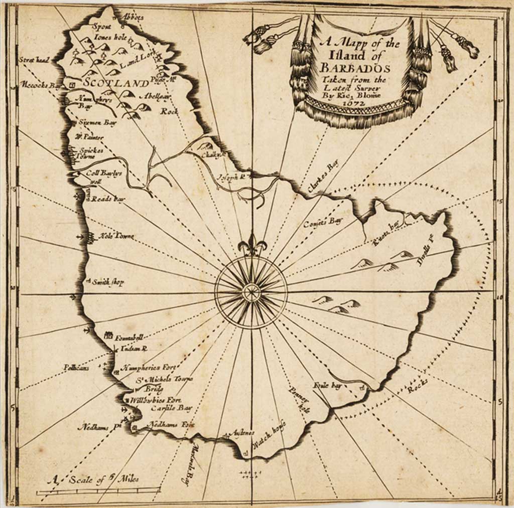
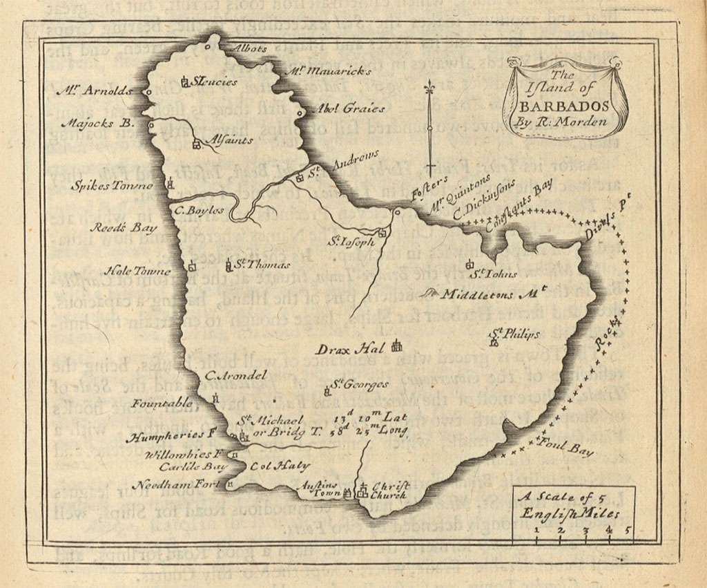
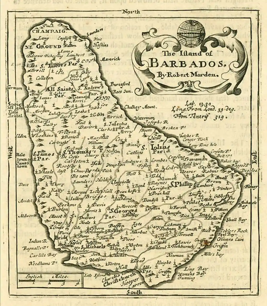
7 [1680] MORDEN (ROBERT)
The Island of Barbados by Robert Morden. 12 x 13 cms.
MORDEN (Robert) The Island of Barbados by Robert Morden. 12 x 13 cms.

David Rumsey Library.
In: Morden (R.) Geography Rectified or A Description of the World, 1680, 1688.
Another edition: with the addition of latitude and longitude data under the title, page no. (70) top right, more place and plantation names. This is entirely re-engraved .
In: Morden (R.) Geography rectified, 3rd & 4th edns. 1693, 1700.
In: Morden ( R.) Atlas Terrestris [1700].
In: Blome (R.) The Present state of His Majesties Isles and Territories in America, London 1687.
Campbell identifies two “editions” of Morden’s map, the earlier of which is said to appear in the 1st and 2nd editions (1680 and 1688) of Morden’s Geography rectified, with the later, “entirely re-engraved”, first appearing in the 3rd edition (1693) of that work. However, the revised version of the map, which as Campbell states is differentiated by the addition of latitude and longitude data under the title and more plantation and place names, in fact first appears in the 2nd edition of Geography rectified, although the further distinguishing feature of “Page 70” at top right is indeed not found until the 3rd edition.
The additional plantation and place names are all to be found in Richard Forde’s map of Barbados (see 8, below), a map generally regarded as providing a considerable advance upon earlier representations of the island, and Jeannette D. Black, in her account of the Forde map in her commentary on The Blathwayt Atlasé, goes so far as to describe Morden’s revision as “a reduction of Forde’s map”. I would suggest, therefore, that the maps used by Morden are sufficiently different to merit being considered separate maps rather than two editions of the same map.
Campbell assigns a date of (1700) to Morden’s Atlas terrestrial, but the John Carter Brown Library ascribes its first appearance to “between May 1688 and November of 1692”, since the maps bear engraved page numbers which do not appear on the examples published in the 1688 edition of Geography rectified, but which are to be found on those in the 1693 edition, announced in the November 1692 Term catalogues. The library also identifies a further issue of Atlas terrestrial appearing after May 1693 but before 1699.
The map appearing in Richard Blome’s The present state of His Majesties isles and territories in America (London: Printed by H. Clark for Dorman Newman, 1687), while clearly based on the later Morden and bearing his name in the cartouche, is from a plate other that that first used in the 2nd edition of Geography rectified, there being differences in the cartouche and in some of the place names. As Black points out, the text of the first edition of Geography rectified had promised to show features on the Barbados map which were not in fact included until the second edition, which suggests that the revision of the map may well have been completed not long after the first edition went to press in 1680. That it was possible for it to be copied and published in Blome’s 1687 work prior to its first appearance in a Morden publication is therefore not surprising.
As has been noted above, the map referred to as an Amsterdam published French edition of Blome (Campbell 4) is in fact an edition of the later Morden map. The map, which is titled Ile des Barbades Par R. Morden and is lettered “p.36” at the top right, appeared in two issues of an anonymous French translation of Blome’s work which seem to be identical apart from their title-pages: L’Amerique anglaise, ou Description des isles et terries du Roi d’Angleterre dans l’Amerique (Amsterdam: Chez Abraham Wolfgang, 1688), and Description des isles et terries cue l’Angleterre possede en Amerique… Traduit de l’anglos (Amsterdam: Aux depend d’Estienne Roger, 1715).
A. Moss

David Rumsey Library.
David Rumsey Library.

The Map House
Daniel Crouch Rare Books

Caribmap
Barry Lawrence Ruderman
8 [1681] FORD (RICHARD)
A New Map of the Island of Barbadoes wherein every Parish, Plantation, Watermill, Windmill & Cattlemill, is described with the name of the Present Possessor, and all things els Remarkable according to a Late Exact Survey thereof. This map is to be sold by Mr. Overton at the White Horse without Newgate Mr. Morden at the Atlas in Cornhill Mr. Berry at the Globe at Charing Cross and Mr. Pask at ye Stationers Arms & Inkbottle on the North Side the Royal Exchange. 56 x 48 cms.
This map shows the already extensive nature of sugar cultivation. There are symbols to depict the typical flora of the various parts of the island and in the bottom right “A New Description of the Island of Barbadoes”, containing statistical data within a decorative cartouche.
Richard Ford, Surveyor, obtained in 1675 the sole right to sell his “plot” of the island. However in the following year a General Order in Council instructed all Governors to send home maps of their plantations, an order which in this case was not obeyed until 1680. The suggested date of 1681 is given on the evidence that in June of that year the Governor, Sir Richard Dutton wrote: “The longitude and latitude of the Island is variously estimated ; no other admeasurement of this Island to be had than that of Richard Ford, a Surveyor, whose description is printed and sold in England”.
This is the first systematic map of the island. The general accuracy of the inland features testifies to the thoroughness of Ford’s survey. The thirty years between Ligon and Ford had seen a complete change in the appearance of the island. Where the Barbados that Ligon knew was an island covered in thick forest and only crossed by one path by the time of Ford’s survey there were plantations almost all over the island and even the hilly areas were criss-crossed with paths. Ford was a Quaker who suffered both fines and imprisonment for his beliefs.
One of the more interesting features of the map is the absence of any indication of the fortifications or names of the churches, which were, according to his Quaker conscience, simply depicted with the name of the parish beside them. It may have been his religion rather than his surveying abilities which Governor Atkins found fault with when in 1680 he sent the map to the Lords of Trade: “I have at last procured a Chart of the Island, but I cannot commend it much.”
Jeannette Black is able to point to documentary evidence which establishes that Forde spelled his surname with an e. She argues that there may have been a state of the map earlier than that described by Campbell, and, replying upon the date on which, as far as she was able to determine, William Berry began to do business from the address given in the cartouche, “at the Globe at Charing Cross”, she ascribes to this issue a publication date of (1675-1676). However, in her London map-sellers, 1660-1720 Sarah Tyacke shows Berry to have advertised from his previous address as late as 14-17 February 1676, which makes 1676 the earliest possible date of publication.
Moreover, the earliest incontrovertible reference to the existence of the map cited by Black occurs when Jonathan Atkins, Governor of Barbados, having been pressed from the highest level since 1675 to furnish a map of the island, is recorded as sending a copy of Forde to England in May 1680. And one may legitimately wonder why, as it noted above, Morden was unable to incorporate the features of Forde’s map into the 1680 edition of his Geography rectified, despite his stated intention of doing so, if it had been available to him since 1676. There would be some grounds, then, for favouring a later date of publication that 1676.
A. Moss

John Carter Brown (JCB) Map Collection
9 [1681-1682] FORD (RICHARD)
Another issue: By Phillip Lea at ye Atlas & Hercules in ye Poultry ouer against ye ould Jury And by Iohn Sellers at his shop on the West side of the Royal Exchange London.
Insets: Plans of the Bridg Toun, Ostines Toun, the Hale Toun and Speights Toun.
The map has been altered in the following ways:
- The original imprint in the cartouche in the top left of the map has been erased and the cartouche left blank. The new imprint appears beneath the scale of miles.
- Four very sketchy town plans have been added around the sides of the map. This is the first instance of town plans on a map of Barbados, though they are little more than enlarged versions of the plans on the body of the map.
- Lines of crosses have been added around the island to indicate rocks.
- At the end of “A New Description of the Island of Barbadoes”, has been added; “Their is lately Printed A New Mapp of Jamaica after this Manner by P. Lea”.
The final issue identified by Campbell, that sold by George Willdey, is dated (c1710). The Royal Arms on the pediment which surmounts the “New Description of the Island of Barbados”, however, have been changed from the traditional Stuart Arms depicted in earlier issues to those adopted by George I, who came to the throne only in August 1714.
Tyacke quotes an advertisement in the Daily Courant of 29th October 1715 showing Willdey at that time to be running both a “Spectacle and Toyshop” near the Dog Tavern in Ludgate Street, an address with which he had been associated with since 1711, and a “Print shop at the the corner of Ludgate Street next to St. Paul’s”. The imprint indicates that by the time this issue was published these two aspects of his business had been consolidated at the latter address, and so late 1715 becomes the earliest possible date of publication.
A. Moss

Norman B. Leventhal
In: Seller (J .) Collection of Charts of the World [London 1690] (Also issued in collections by Visscher and others, and separately.)
Another issue: Sold by George Willdey at the Great Toy Spectacle, Chinaware and Print Shop, ye Corner of Ludgate Street near St. Pauls [c. 1710]
Lea’s imprint has been removed from beneath the scale of miles.

Old World Auctions
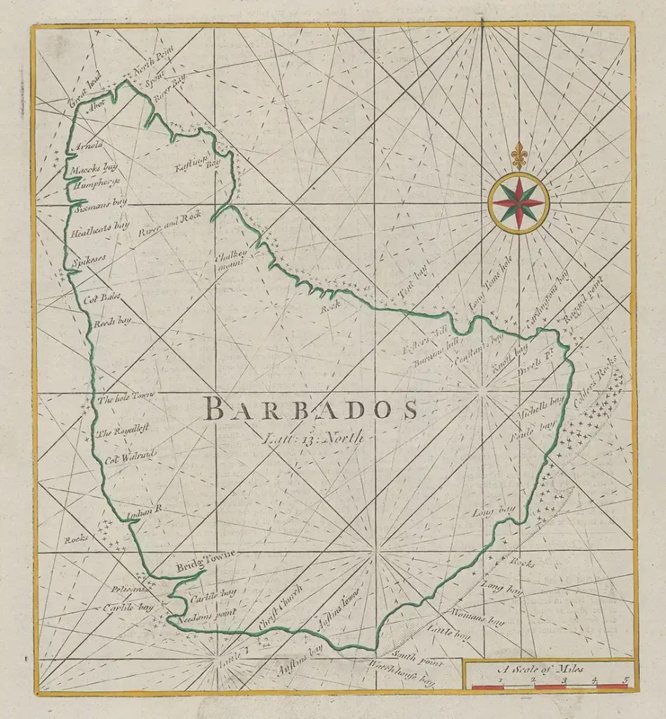
10 [1682] SELLER (JOHN)
The Island of Barbados by John Seller. 14¼ x 11¼ cms.
In: Seller (J.) Atlas Maritimus: or a Sea-Atlas: describing the sea-coasts in most of the known Parts of the World. London 1682.
In: Seller (J.) Barbados Almanack for XXX yeares [1686] (see also 11 [1686] SELLER (JOHN)).
In: Seller (J.) Hydrographia Universalis or a Book of Maritime Charts [1690]. This is based on Ford’s map.
In: Seller (J.) Atlas terrestis (London: (1700?). Map 40 in volume 2.

Yale Library – image 43 of 50
W [1684] SLOANE MANUSCRIPTS
Manuscript map in the British Library, coloured photograph, 33 by 48 cm..
A map of the island of Barbadoes, on vellum: 1 f. 5 in. x 1 f. 2 in. It accompanies an account of Barbadoes and the government 1683-1684.
Sloane MS. 2441. Available at The British Library reading room.

British Library
(unavailable after the British Library was hacked on 28th October 2023 by a ransomware attack)
Click here to see a high resolution image
11 [1686] SELLER (JOHN) – no image available
[Barbados]. 7¾ X 5½ cms. In: Seller (J.) Barbados Almanack for XXX yeares.
A miniature sketch of the Island appearing on the title page. See also 1682 Seller.
[No image sourced – please contact Jim Webster via the BajanThings Contact Burts link to assist]
12 [1689] THORTON (JOHN) & FISHER (WILLIAM)
The Iland of Barbados by John Thornton at ye Platt in ye Minories And by Will Fisher at ye Postorn Gate on Tower Hill, London. 25½ x 42 cms.
With Bermuda, the two maps divided by a double curved rule, Barbados on the right.
In: The English Pilot, the Fourth Book. West India Navigation . . . London, printed for William Fisher and John Thornton 1689.
Another issue: 1704-6.
In later editions of the English Pilot, published under the imprints of Thornton & Mount, Mount & Page, Mount & Davidson, the maps were divided and printed separately as text illustrations without the title Cartouches. Through the many editions, printed both in London and Dublin, the engraved map of Barbados remained substantially unchanged although it was re-engraved once, about 1750, after which the compass rose is shown entire in the middle of the map, not cut off at. the top. The surrounding text was reset many times and the silhouette of the Island, “when it bears WNW, 7 or 8 leagues off” was changed at least twice and so drastically that it is difficult to believe that it is the same island they depict.
Another issue 1775 – Complete edition with text and Map – (see: Open Library)
Final Issue: 1794 – (see: David Rumsey Map Collection)
Campbell indicates that the map was “re-engraved once, about 1750”, but a close comparison of the 1728 and 1773 issues led me to conclude that they emanate from the same plate, although for the later issue some of the rhumb lines have been strengthened, and as Campbell notes, the compass rose occupies a lower position on the plate. In the later version about half a centimetre has in fact been cut off the top of the plate, and it is this which necessitated the re-engraving of the compass rose, for the centre of the original compass rose was located very close to the top border.
In his introduction to The English Pilot. The Fourth Book. London, 1689 (Amsterdam: Theatrum Orbis Terrarum, 1967) Coolie Verner provides a comprehensive account of the publishing history of the work, including a “List of Editions of the Fourth Book”, the final edition being in 1794, and a “List of chart titles recorded in copies of the Fourth Book” with inclusive dates of their appearance. The Barbados map is listed as appearing in all editions.
A. Moss

Yale Library (1698 Edition)

Old World Auctions
The Map House

In Coolie Verner’s study of the English Pilot (A Carto-bibliographical Study of The English Pilot The Fourth Book. Charlottesville, 1960) he provides an excellent summary of the atlas:
The English Pilot was the first major sea-atlas produced in England. In its final form it consisted of five separate books, and The Fourth Book was the first wholly English sea-atlas of American waters. Although the idea originated with John Seller, he was involved in producing only the first two books. William Fisher and John Thornton produced The Fourth Book in 1689, and their successors Mount and Page continued to print it for over 100 years … Seller’s proposal for a ‘Sea Waggoner’ resulted in the production of The English Pilot, which consisted of five separate volumes with a common generic title. Book One included the southern navigation and Book Two the northern. Book Three was concerned with the Orient, Book Four with America, and Book Five contained Africa. Each book or volume has its own independent publishing history and appeared in numerous editions. The five separate books constitute a set only by virtue of the general title, and under that title The English Pilot is the first great sea-atlas produced in England. Of the five books, the fourth has the longest publication history and is the best known. (Verner, p. v).
Coolie Verner – A Carto-bibliographical Study of The English Pilot The Fourth Book. Charlottesville, 1960
The English Pilot, The Fourth Book was an extremely popular and important collection of charts that was published in at least 37 editions between 1689 and 1794. The number of maps grew from 18 in the first edition to 26 in the last edition. Though this is not the last edition, it also includes the largest compliment of charts of any edition.

Johns Hopkins University – attribution: Bibliothèque nationale de France (National Library of France)
W [c. 1690] HACK (WILLIAM)
Island of Barbados probably from a sea atlas of the coasts of eastern North America and the West Indies.
A description of Coasts Islands & ca. in the North Sea of America: vizt. New-foundland new England New Scotland New France Accadia New york East & West New Jarsey Pennsylvania Maryland Virginia Carolina Florida New Spain lucatan Honduras Nicaragua Costarica New Calidonia Darien Terra Firma New Andalusia Guiana Popayan & part of the Coast of Peru in the south seas; Islands of Anti Costy St. John Plata Sable Martins Vineyard Rhode Block Fishers Long Island Staten, Sommers or Bermudas Bahamas Providence St. Andrews Exuma Elutheria Hinagua Cuba Jamaica Hispaniola Saona Porto Rico Virgins Caribies Barbados Tobago Trinidada Margarita Bonaray Quirissao [sic]
Transcription of lower right on map:
“This island of Barbados was the second Island settled by the English nation in the West Indies or Caribies & is the Eastmost or Windermost Island of all the Caribies it is very healthfully fertile & the best soil of all the Islands many hundreds of the inhabitants have raised great fortune’s to themselves & properties & although it is an Island not much above 20 miles in length & in some places 14 miles in breath yet it hath loaded of great & finale for this 50 years about 300 sale of ships per annum with Sugar Ginger Indigo Cotton Wool Rhum – mallaso’s & insomuch that the inhabitants lives plentiful splendid & very rich; there is a constant militia of four regiments of foot & 1500 men in a regiment & two regiments of hors of 700 in a regiment & a troop of the Governours Lite Guard of 140 hors so that this Island if there be occasion to can bring 20000 effective men into the field it is Govern’d by her Majesties commission with a Governour council & assemble the greatest part of the council being always nominated by her Majistie but the assembly are chosen by the freeholders of he Island two out of every parish & these all together taketh laws with the general consent for the good of the country lays all taxes for defraying of Public charges the island being divided into five precincts each having its particular court of Judicature where all causes comences & have there end being no apeale to bebrought but to the Governor & council as to a court of chancery so it might be said of this Island that the people are happy under such a Government.”
More on William Hack by Richard Boulind 1981. Colonial Society of Massachusetts
Note: the reflection or double image of the outline of Barbados is a result of the map having been folded and is caused by verdigris a green or greenish-blue poisonous pigment resulting from the action of acetic acid on copper and consisting of one or more basic copper acetates from the original copper plates.

British Library
(unavailable after the British Library was hacked on 28th October 2023 by a ransomware attack)
Click here to see a high resolution image
13 [1695] COPENS (SAMUEL)
A Prospect of Bridge Town in Barbados. 1695. [Engraved by J. Kip].
Inset: Plan of Bridge Town.
This is a panorama showing a throng of ships in Carlisle “Bay with the fortifications at Needham‘s Point. Bruester’s small Battery, Willoughbie’s Fort, and James’ Fort. Inland can be seen scattered windmills but few traces of the dense indigenous forest that covered the island.
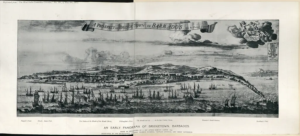
The National Archives UK
Library of Congress
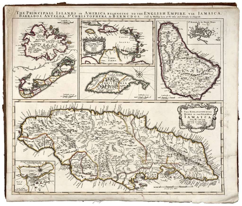
14 [1696] LEA (PHILLIP)
[Barbados]. 17 x 21 cms. 5 separate maps on a sheet entitled: The Principall Islands in America belonging to the English Empire viz. Jamaica, Barbados, Antegoa, St. Christophers, and Bermudoa. 51.3 x 61.3 cms. Philip Lea, London. b&w with colour hi-lites.
Inset: St. Michael or the Bridg Town.
A map that usually occurs as an insert in compilations by Visscher, de Wit, and de Ram.
No. 62 of 69 maps bound together.
In copies examined at the British Library, the Boston Public Library and the John Carter Brown Library the spelling “Bermudos” rather than “Bermudoa” is used in the title, and “Phillip” rather than “Philip” in the imprint.
The full imprint reads: Sold by Phillip Lea at the Atlas and Hercules in Cheapside.
A. Moss
Yale Library
This is: The Printed Maps of Barbados – Part 1: 1500s – 1700. Click here to go to the next sections of The Printed Maps of Barbados 1500s – 1980s: